
KwaZulu-Natal topographic map
Interactive map
Click on the map to display elevation.
KwaZulu-Natal
KwaZulu-Natal has a varied yet verdant climate thanks to diverse, complex topography. Generally, the coast is subtropical with inland regions becoming progressively colder. Durban on the south coast has an annual rainfall of 1009 mm, with daytime maxima peaking from January to March at 28 °C (82 °F) with a minimum of 21 °C (70 °F), dropping to daytime highs from June to August of 23 °C (73 °F) with a minimum of 11 °C (52 °F). Temperature drops towards the hinterland, with Pietermaritzburg being similar in the summer, but much cooler in the winter. Ladysmith in the Tugela River Valley reaches 30 °C (86 °F) in the summer but may drop below freezing point on winter evenings. The Drakensberg can experience heavy winter snow, with light snow occasionally experienced on the highest peaks in summer. The Zululand north coast has the warmest climate and highest humidity, supporting many sugar cane farms around Pongola.
About this map
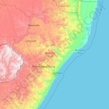
Name: KwaZulu-Natal topographic map, elevation, terrain.
Location: KwaZulu-Natal, South Africa (-31.21760 28.87348 -26.80442 33.10236)
Average elevation: 777 m
Minimum elevation: -1 m
Maximum elevation: 3,405 m
Other topographic maps
Click on a map to view its topography, its elevation and its terrain.
Broederstroom
South Africa > North West > Bojanala Platinum District Municipality > Madibeng Local Municipality
Average elevation: 1,264 m
Ixopo
South Africa > KwaZulu-Natal > Sisonke District Municipality > Ubuhlebezwe Local Municipality
Average elevation: 1,009 m
Pretoria
South Africa > Gauteng > City of Tshwane Metropolitan Municipality
Pretoria is situated approximately 56 km (35 mi) north-northeast of Johannesburg in the northeast of South Africa, in a transitional belt between the plateau of the Highveld to the south and the lower-lying Bushveld to the north. It lies at an altitude of about 1,339 m (4,393 ft) above sea level, in a warm,…
Average elevation: 1,363 m
Middelburg
South Africa > Mpumalanga > Nkangala > Steve Tshwete Local Municipality
Average elevation: 1,493 m
Kloof
South Africa > KwaZulu-Natal > eThekwini Metropolitan Municipality
The further subdivisions and sale of portions of Richmond Farm No. 999 by the Field heirs after 1901 resulted in the birth of Kloof as a residential area: numerous plots were sold to wealthy Durban residents and businessmen, who built country house retreats close to the city, but (due to its 550 m above sea…
Average elevation: 480 m
Garies
South Africa > Northern Cape > Namakwa District Municipality > Kamiesberg Local Municipality
Average elevation: 264 m
Chaos
South Africa > Western Cape > Cape Winelands District Municipality > Witzenberg Local Municipality
Average elevation: 1,346 m
Suiderstrand
South Africa > Overberg District Municipality > Cape Agulhas Local Municipality
Average elevation: 34 m
Richmond
South Africa > Northern Cape > Pixley ka Seme District Municipality > Ubuntu Local Municipality
Average elevation: 1,453 m
Orania
South Africa > Northern Cape > Pixley ka Seme District Municipality > Thembelihle Local Municipality
Average elevation: 1,116 m
Schweizer-Reneke
South Africa > North West > Dr Ruth Segomotsi Mompati District Municipality > Mamusa Local Municipality
Average elevation: 1,318 m
Table Mountain
South Africa > Western Cape > City of Cape Town > Cape Town
Table Mountain is at the northern end of a sandstone mountain range that forms the spine of the Cape Peninsula that terminates approximately 50 kilometres (30 mi) to the south at the Cape of Good Hope and Cape Point. Immediately to the south of Table Mountain is a rugged "plateau" at a somewhat lower elevation…
Average elevation: 583 m
Zwelitsha
South Africa > Eastern Cape > Buffalo City Metropolitan Municipality
Average elevation: 251 m
Cape Town
South Africa > Western Cape > City of Cape Town
The Cape Peninsula is 52 km (30 mi) long from Mouille Point in the north to Cape Point in the south, with an area of about 470 km2 (180 sq mi), and it displays more topographical variety than other similar sized areas in southern Africa, and consequently spectacular scenery. There are diverse low-nutrient…
Average elevation: 53 m
Strydenburg
South Africa > Northern Cape > Pixley ka Seme District Municipality > Thembelihle Local Municipality
Average elevation: 1,097 m
Elim
South Africa > Limpopo > Vhembe District Municipality > Makhado Local Municipality
Average elevation: 869 m
Etwatwa
South Africa > Gauteng > City of Ekurhuleni Metropolitan Municipality
Average elevation: 1,611 m
Sandton
South Africa > Gauteng > City of Johannesburg Metropolitan Municipality
Average elevation: 1,583 m
Brits
South Africa > North West > Bojanala Platinum District Municipality > Madibeng Local Municipality
Average elevation: 1,120 m
Heidelberg
South Africa > Gauteng > Sedibeng District Municipality > Lesedi Local Municipality
Average elevation: 1,581 m
Soweto
South Africa > Gauteng > City of Johannesburg Metropolitan Municipality
Average elevation: 1,638 m
Richards Bay
South Africa > KwaZulu-Natal > King Cetswayo District Municipality
Average elevation: 31 m
De Aar
South Africa > Northern Cape > Pixley ka Seme District Municipality > Emthanjeni Local Municipality
Average elevation: 1,257 m
Abseil Viewpoint
South Africa > Eastern Cape > Sarah Baartman District Municipality > Kou-Kamma Local Municipality
Average elevation: 623 m
Mbombela (Nelspruit)
South Africa > Mpumalanga > Mbombela (Nelspruit)
Nelspruit Airport, located about 9 km (6 mi) south west of the city, is the city's original airport owned and operated by the municipality. There are over a hundred aircraft based at the airport. The majority of the aircraft are privately owned but there are several commercial aircraft based here as well.…
Average elevation: 833 m
Rustenburg
South Africa > North West > Bojanala Platinum District Municipality
Rustenburg has a humid subtropical climate (Köppen Cwa), with a relatively high degree of diurnal temperature variation due to the high elevation. It has very warm summers (from December to February) and mild winters (from June to August). Due to the altitude, summers are not quite as hot as one might expect.…
Average elevation: 1,217 m
Umtamvuna Nature Reserve
South Africa > KwaZulu-Natal > Ugu District Municipality > Hibiscus Coast Local Municipality
Average elevation: 248 m
Worcester
South Africa > Western Cape > Cape Winelands District Municipality > Breede Valley Local Municipality
Worcester is located at an elevation of 220 metres (720 ft) and can be reached by road either travelling on the N1 highway through the Huguenot Tunnel or by driving through spectacular mountain passes. From Cape Town Du Toitskloof, from Wellington Bainskloof, from Malmesbury, Western Cape Nieuwekloof, from…
Average elevation: 252 m
Stellenbosch
South Africa > Western Cape > Cape Winelands District Municipality > Stellenbosch Local Municipality
Stellenbosch is 53 km (33 mi) east of Cape Town via National Route N1. Stellenbosch is in a hilly region of the Cape Winelands, and is sheltered in a valley at an average elevation of 136 m (446 ft), flanked on the west by Papegaaiberg (Afrikaans: Parrot Mountain), which is actually a hill. To the south is…
Average elevation: 287 m
Germiston
South Africa > Gauteng > City of Ekurhuleni Metropolitan Municipality
Average elevation: 1,635 m
Wellington
South Africa > Western Cape > Cape Winelands District Municipality > Drakenstein Local Municipality
Stretching for approximately 18 kilometers (11 miles), the pass rises to an altitude of 595 meters (1,952 feet) at its highest point. It winds through rugged mountains, offering spectacular vistas of the surrounding valleys, rivers, and fynbos-covered landscapes. The route is popular with tourists, cyclists,…
Average elevation: 168 m
Yzerfontein
South Africa > Western Cape > Swartland Local Municipality > Yzerfontein
Average elevation: 8 m
Eshowe
South Africa > KwaZulu-Natal > King Cetswayo District Municipality > uMlalazi Local Municipality > Eshowe
Average elevation: 457 m
Betty's Bay
South Africa > Western Cape > Overstrand Local Municipality > Betty's Bay
Average elevation: 210 m
Tembisa
South Africa > Gauteng > City of Ekurhuleni Metropolitan Municipality > Tembisa
Average elevation: 1,594 m
Greytown
South Africa > KwaZulu-Natal > Umzinyathi District Municipality > Umvoti Local Municipality
Average elevation: 1,125 m
SE1
South Africa > Gauteng > Sedibeng District Municipality > Emfuleni Local Municipality
Average elevation: 1,480 m
Magoebaskloof Dam
South Africa > Limpopo > Mopani District Municipality > Greater Tzaneen Local Municipality
Average elevation: 903 m