Geolocate

Taylor County topographic map

Interactive map

Click on the map to display elevation.

About this map

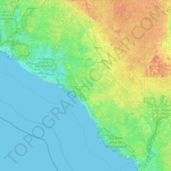
Name: Taylor County topographic map, elevation, terrain.

Location: Taylor County, Florida, United States (29.62870 -83.99988 30.30439 -83.31896)

Average elevation: 10 m

Minimum elevation: -3 m

Maximum elevation: 40 m

Other topographic maps

Click on a map to view its topography, its elevation and its terrain.

The Villages

United States > Florida > Sumter County

Average elevation: 25 m

Tampa

United States > Florida > Hillsborough County

Average elevation: 11 m

Lee County

United States > Florida

Average elevation: 5 m

Villas

United States > Florida > Lee County

Average elevation: 5 m

Okeechobee County

United States > Florida

Average elevation: 12 m

Titusville

United States > Florida > Brevard County

Average elevation: 4 m

Cape Coral

United States > Florida > Lee County

Average elevation: 4 m

Al Mar

United States > Florida > Hillsborough County > Tampa

Average elevation: 8 m

Largo

United States > Florida > Pinellas County

In 2010, Largo's total area was 18.6 square miles (48.1 km2), of which 17.6 square miles (45.6 km2) was land and 0.97 square miles (2.5 km2), or 5.22%, was water. As of 2004, there were 651 acres (2.6 km2) of park lands. The city's lowest elevation is sea level. At its highest, the city's elevation is about 69…

Average elevation: 9 m

Manatee County

United States > Florida

Average elevation: 13 m

Seminole

United States > Florida > Pinellas County

Average elevation: 9 m

Safety Harbor

United States > Florida > Pinellas County

Average elevation: 11 m

Oxford

United States > Florida > Sumter County

Average elevation: 29 m

Palmetto Palms

United States > Florida > Lee County

Average elevation: 3 m

Seminole County

United States > Florida

Average elevation: 14 m

Palm Harbor

United States > Florida > Pinellas County

Average elevation: 9 m

Venice

United States > Florida > Sarasota County

Average elevation: 4 m

Collier County

United States > Florida

Average elevation: 5 m

Hillsborough County

United States > Florida

Average elevation: 20 m

Lake Stone

United States > Florida > Escambia County

Average elevation: 40 m

Marion County

United States > Florida

Marion County is generally composed of rolling hills, much like most of the rest of Florida. The highest elevation is about 60 meters (200 feet). The majority of its trees consist of live oaks, pines, and palm trees.

Average elevation: 24 m

Holmes County

United States > Florida

Average elevation: 39 m

Jacksonville

United States > Florida > Duval County

Average elevation: 10 m

Miami

United States > Florida > Miami-Dade County

Miami and its suburbs are located on a broad plain between the Everglades to the west and Biscayne Bay to the east, which extends from Lake Okeechobee southward to Florida Bay. The elevation of the area averages at around 6 ft (1.8 m) above sea level in most neighborhoods, especially near the coast. The…

Average elevation: 5 m

Loughman

United States > Florida > Polk County > Loughman

Average elevation: 32 m

Cairo

United States > Florida > Hillsborough County > Tampa

Average elevation: 10 m

Orlando

United States > Florida > Orange County

Average elevation: 30 m

Leesburg

United States > Florida > Lake County

Average elevation: 26 m

Key

United States > Florida > Monroe County

Average elevation: 0 m

Miramar

United States > Florida > Broward County

Average elevation: 6 m

Indian River County

United States > Florida

Average elevation: 8 m

Sanibel

United States > Florida > Lee County

Average elevation: 1 m

Brevard County

United States > Florida

Average elevation: 9 m

Sebring

United States > Florida > Highlands County

Average elevation: 34 m