
Kahurangi National Park topographic map
Interactive map
Click on the map to display elevation.
About this map
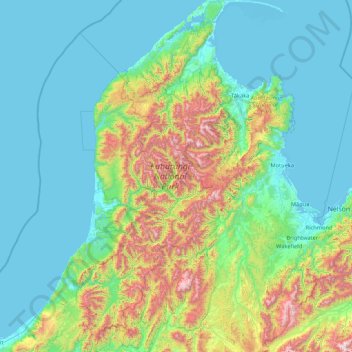
Name: Kahurangi National Park topographic map, elevation, terrain.
Location: Kahurangi National Park, West Coast, New Zealand (-41.78847 172.09346 -40.50769 172.92143)
Average elevation: 338 m
Minimum elevation: -1 m
Maximum elevation: 1,906 m
New Zealand trails, hiking, mountain biking, running and outdoor activities
Other topographic maps
Click on a map to view its topography, its elevation and its terrain.
Port hills
New Zealand > Canterbury > Christchurch City > Linwood-Central-Heathcote Community
Average elevation: 246 m
Auckland Domain
New Zealand > Auckland > Auckland
During the 2023 Auckland Anniversary Weekend floods, a lake reformed in the lower elevation area of Pukekawa / Auckland Domain that was once a wetland.
Average elevation: 49 m
Hanmer Springs
New Zealand > Canterbury > Hurunui District
The Jacks Pass – Clarence River – Jollies Pass Loop is a 25 kilometer loop which is not technically challenging however it takes between two to four hours to complete. It can be ridden in either direction: West over Jacks Pass (869m) or East over Jollies Pass (850m). As the entire ride is at high elevation…
Average elevation: 490 m
Cromwell
New Zealand > Otago > Central Otago District > Cromwell Community > Cromwell
Average elevation: 330 m
Waihou Valley
New Zealand > Northland > Far North District > Kaikohe-Hokianga Community
Average elevation: 86 m
Pungaere Stream
New Zealand > Northland > Far North District > Bay of Islands-Whangaroa Community
Average elevation: 183 m
Pukawa
New Zealand > Northland > Far North District > Kaikohe-Hokianga Community
Average elevation: 101 m
Ngāwī
New Zealand > Wellington > South Wairarapa District > Martinborough Community
Average elevation: 97 m
Fortrose
New Zealand > Southland > Southland District > Waihopai Toetoe Community
Average elevation: 12 m
Hikuraki / North Mavora Lake
New Zealand > Southland > Southland District > Fiordland Community
Average elevation: 1,071 m
Cass
New Zealand > Canterbury > Selwyn District
The topography of the Cass area was formed by repeated glaciation in the Pleistocene, with the valley floor built up by river fans as the glaciers retreated and the nearby Lakes Sarah and Grasmere enclosed by moraines and ice-eroded rocks. Many of the valleys around Cass post-date the retreat of the Poulter…
Average elevation: 667 m
Ettrick
New Zealand > Otago > Central Otago District > Teviot Valley Community
Average elevation: 105 m
Tokanui
New Zealand > Southland > Southland District > Waihopai Toetoe Community
Average elevation: 85 m
Broadwood
New Zealand > Northland > Far North District > Kaikohe-Hokianga Community
Average elevation: 144 m
Whirinaki
New Zealand > Northland > Far North District > Kaikohe-Hokianga Community
Average elevation: 71 m
Waitākere Bay
New Zealand > Auckland > Waitakere Ranges > Te Henga / Bethells Beach
Average elevation: 18 m
Banks Peninsula
New Zealand > Canterbury > Christchurch City > Banks Peninsula Community > Pigeon Bay
Average elevation: 277 m
Reefton
New Zealand > West Coast > Buller District
Located in the Inangahua Valley at an altitude of 194m, Reefton falls under the Köppen-Geiger climate classification of Cfb (Oceanic), though the town's sheltered inland location lends its climate less maritime influence than coastal areas; as such, Reefton has recorded both the extreme highest temperature of…
Average elevation: 310 m
Taumarunui
New Zealand > Manawatu-Whanganui > Ruapehu District
Under the Köppen, Taumarunui has an Oceanic climate:(Cfb). Due to location, low altitude and Geography surroundings, Taumarunui is more liable to warm to hot summers than other central North Island centres and in winter Taumarunui is cold and frosty. Rainfall yearly is 1,449 mm (57.047244 in). Annual sunshine…
Average elevation: 245 m
Whangamarino
New Zealand > Bay of Plenty > Rotorua Lakes District > Okere Falls
Average elevation: 317 m
Mount Tongariro
New Zealand > Manawatu-Whanganui > Ruapehu District
The high altitude and severe alpine climate between March and October allow snowfall in the winter (there are commercial ski-fields at neighbouring Mount Ruapehu) and rain can freeze, causing verglas; in contrast in the mid to late summer, the mountains can be bare apart from remnant patches of snow in…
Average elevation: 1,675 m
Papamoa Hills Regional Park
New Zealand > Bay of Plenty > Western Bay of Plenty District
Average elevation: 53 m