
Make a donation
Europe topographic map
Click on the map to display elevation.
Make a donation
Europe
Europe's topography is characterized by a striking contrast between its rugged southern mountains and the expansive plains of the north. The continent is often described as a "peninsula of peninsulas," featuring major peninsulas like the Iberian, Italian, and Balkan, each with unique geological features. In the southern regions, mountain ranges such as the Alps and the Pyrenees rise dramatically, with elevations frequently exceeding 9,800 feet (3,000 meters). Moving northward, the terrain gradually descends into the Great European Plain, a vast lowland stretching from the Pyrenees in the west to the Ural Mountains in the east, where most elevations are below 1,640 feet (500 meters). This plain is interspersed with rolling hills and valleys, making it one of the most agriculturally productive areas in Europe, while also being historically significant due to its accessibility for trade and invasion. The northern regions, including Scandinavia and the British Isles, are marked by fjords and rugged uplands, contributing to a diverse and complex landscape across the continent.
Make a donation
About this map
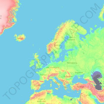
Name: Europe topographic map, elevation, terrain.
Location: Europe (26.00000 -15.00000 76.00000 35.00000)
Average elevation: 223 m
Minimum elevation: -30 m
Maximum elevation: 3,987 m
Make a donation
Other topographic maps
Click on a map to view its topography, its elevation and its terrain.
Philippines
The Philippines is an archipelago of approximately 7,641 islands, with a total land area of about 300,000 square kilometers. The terrain is predominantly mountainous, with narrow coastal plains and valleys. The highest peak is Mount Apo on Mindanao, reaching 2,954 meters (9,692 feet) above sea level. Other…
Average elevation: 33 m
Las Vegas
United States > Nevada > Clark County
The peaks surrounding Las Vegas reach elevations of over 10,000 feet (3,000 m), and act as barriers to the strong flow of moisture from the surrounding area. The elevation is approximately 2,030 ft (620 m) above sea level. According to the United States Census Bureau, the city has a total area of 135.86 sq mi…
Average elevation: 767 m
District of Columbia
The highest natural elevation in the District is 409 feet (125 m) above sea level at Fort Reno Park in upper northwest Washington. The lowest point is sea level at the Potomac River. The geographic center of Washington is near the intersection of 4th and L Streets NW.
Average elevation: 49 m
Metro Manila
The Coastal Margin or Lowland is a flat and low plain that faces Manila Bay. Located here is Manila, Navotas, parts of Malabon, and the western part and reclaimed areas of Pasay and Parañaque, where the ground elevation ranges from zero meters on Manila Bay to five meters at the west side of the cities of…
Average elevation: 43 m
Make a donation
New Zealand
New Zealand (Māori: Aotearoa [aɔˈtɛaɾɔa]) is an island country in the southwestern Pacific Ocean. It consists of two main landmasses—the North Island (Te Ika-a-Māui) and the South Island (Te Waipounamu)—and over 700 smaller islands. It is the sixth-largest island country by area, covering 268,021…
Average elevation: 399 m
Make a donation
Fiji
Average elevation: 386 m
Tennessee
Tennessee features a diverse and varied topography characterized by its distinct regions, which include the Appalachian Mountains, the Central Basin, and the Gulf Coastal Plain. The state’s highest point is Clingmans Dome, rising to about 6,643 feet (2,025 meters) above sea level, while the lowest point is…
Average elevation: 233 m
Make a donation
Henderson
United States > Nevada > Clark County
Henderson is a city in Clark County, Nevada, United States, about 16 miles (26 km) southeast of downtown Las Vegas. It is the second largest city in Nevada, after Las Vegas, with an estimated population of 320,189 in 2019. The city is part of the Las Vegas Valley. Henderson occupies the southeastern end of the…
Average elevation: 688 m
Make a donation
Make a donation
Make a donation
Make a donation
Make a donation
Make a donation
Make a donation
Make a donation
Chatham Island
Much of the area between the bays is taken up by the large Te Whanga Lagoon, which drains to the sea to the east, into the southern half of Hanson Bay. This lagoon covers about 160 square kilometres (62 sq mi), and drains several small rivers that rise in the hills at the south end of the island. The next…
Average elevation: 18 m
Make a donation
South Island
The South Island, also officially named Te Waipounamu, is the larger of the two major islands of New Zealand in surface area, the other being the smaller but more populous North Island. It is bordered to the north by Cook Strait, to the west by the Tasman Sea, and to the south and east by the Pacific Ocean.…
Average elevation: 201 m
Make a donation
Manawatū-Whanganui
The area includes a variety of landscape formations. Districts close to the Volcanic Plateau are higher and more rugged, often subject to harsh temperatures in winter. The Manawatū District has a much gentler topography, consisting mainly of the flat, tree-studded Manawatū Plains that run between the ranges…
Average elevation: 306 m
Fiordland National Park
Several large lakes lie wholly or partly within the park's boundaries, notably Lake Te Anau and Lake Manapouri, both on the western boundary of the national park, as well as the southern lakes Lake Monowai, Lake Hauroko, and Lake Poteriteri. All of these lakes exhibit the topography typical of glacier-carved…
Average elevation: 417 m
Make a donation
Southland
Fiordland has a wet mountain climate though conditions vary due to altitude and exposure. Rainfall is the highest in the country and varies between 6,500 and 7,500 mm annually. The farthest coastal reaches of Fiordland are characterized by a limited temperature range with increasing rainfall at higher…
Average elevation: 229 m
Auckland
The Auckland Volcanic Field has contributed greatly to the growth and prosperity of the Auckland Region since the area was settled by humans. Initially, the maunga (scoria cones) were occupied and established as pā (fortified settlements) by Māori due to the strategic advantage their elevation provided in…
Average elevation: 30 m
Make a donation
Nashville
United States > Tennessee > Davidson County
Nashville lies on the Cumberland River in the northwestern portion of the Nashville Basin. Nashville's elevation ranges from its lowest point, 385 feet (117 m) above sea level at the Cumberland River, to its highest point, 1,163 feet (354 m) above sea level in the Radnor Lake State Natural Area. Nashville also…
Average elevation: 184 m
Napier
The topography puts Napier in danger from a tsunami, as the centre of the commercial city is near sea level – should the sea ever crest Marine Parade, the sea would run through to Ahuriri. Furthermore, by virtue of its pre-1931 existence, the bulk of Napier is susceptible to soil liquefaction, the risk…
Average elevation: 12 m
Palmerston North City
New Zealand > Manawatu-Whanganui
Although the land Palmerston North is situated on is bounded by the lofty Ruahine and Tararua ranges in the east and south respectively, the city has a predominantly flat appearance. The occasional rise in elevation occurs further away from the river and is especially pronounced in the north and northeast, and…
Average elevation: 133 m
Make a donation
Jerusalem
Jerusalem occupies a rugged hilltop setting on a rocky spur within the Judaean Mountains, where the urban landscape rises around about 2,575 feet (785 m) above sea level and is shaped by a compact pattern of limestone ridges, saddles, slopes, and deeply incised dry valleys. The Old City and surrounding…
Average elevation: 661 m
Make a donation
Kerala
The state is wedged between the Laccadive Sea and the Western Ghats. Lying between northern latitudes 8°18' and 12°48' and eastern longitudes 74°52' and 77°22', Kerala experiences humid tropical rainforest climate with some cyclones. The state has a coast of 590 km (370 mi) and the width of the state…
Average elevation: 251 m
Make a donation
Tararua Forest Park
The park supports diverse ecosystems, from lowland podocarp-broadleaf forest to alpine tussock tops. Common canopy trees include rimu, rātā, kāmahi and tawa, with beech forest dominating higher elevations. The alpine zone features tussocks, leatherwood and alpine herbs.
Average elevation: 276 m
Make a donation
Mount Richmond Forest Park
Established in 1977, the forest park is located between Nelson and Marlborough and consists of 1,659 km2 (641 sq mi) of conservation estate. Around 80% of the area is covered in bush. The most notable peak in the forest park is Mount Richmond, which has an elevation above sea level of 1,760 metres (5,770 ft).
Average elevation: 403 m
Westland Tai Poutini National Park
Westland Tai Poutini National Park covers 1,320 square kilometres (510 sq mi) exclusively on the western side of the South Island's main divide, making it New Zealand's fifth largest national park. The park covers a wide variety of environments, ranging from high alpine tundra near the park's border with…
Average elevation: 685 m
Mount Aspiring National Park
Mount Aspiring National Park covers 3,562 square kilometres (1,375 mi2) at the southern end of the Southern Alps, directly to the west of Lake Wānaka, and is popular for tramping, walking and mountaineering. Mount Aspiring / Tititea, elevation 3,033 metres (9,951 ft) above sea level, gives the park its name.…
Average elevation: 770 m
Make a donation
Kahurangi National Park
The special character of flora and fauna in the region was recognised prior to 1920. One particular example is the Gouland Downs, an area with unusual geology and vegetation, situated at around 600 m (2,000 ft) elevation to the west of Mt Perry. The Gouland Downs was one of eleven sanctuaries designated by the…
Average elevation: 338 m
Make a donation
Cook Strait
The strait is named after James Cook, the first European commander to sail through it, in 1770. The waters of Cook Strait are dominated by strong tidal flows. The tidal flow through Cook Strait is unusual in that the tidal elevation at the ends of the strait are almost exactly out of phase with one another, so…
Average elevation: 70 m
Make a donation
Mangawhero River
New Zealand > Manawatu-Whanganui
The source of the Mangawhero River is located on the slopes of Mt Ruapehu at elevation of approximately 1,800 m (5,900 ft). The river begins within the area of the Tūroa skifield and flows down the slopes of the mountain in a south west direction. The Ohakune Mountain Road, built during the 1950s and 60s,…
Average elevation: 460 m
Make a donation
Make a donation
Make a donation