
Okuku Reservoir topographic map
Interactive map
Click on the map to display elevation.
About this map
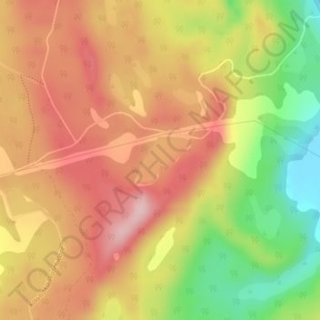
Name: Okuku Reservoir topographic map, elevation, terrain.
Average elevation: 166 m
Minimum elevation: 53 m
Maximum elevation: 247 m
New Zealand trails, hiking, mountain biking, running and outdoor activities
Other topographic maps
Click on a map to view its topography, its elevation and its terrain.
Port hills
New Zealand > Canterbury > Christchurch City > Linwood-Central-Heathcote Community
Average elevation: 246 m
Hanmer Springs
New Zealand > Canterbury > Hurunui District
The Jacks Pass – Clarence River – Jollies Pass Loop is a 25 kilometer loop which is not technically challenging however it takes between two to four hours to complete. It can be ridden in either direction: West over Jacks Pass (869m) or East over Jollies Pass (850m). As the entire ride is at high elevation…
Average elevation: 490 m
Cromwell
New Zealand > Otago > Central Otago District > Cromwell Community > Cromwell
Average elevation: 330 m
Kapiti Island
New Zealand > Wellington > Kapiti Coast District
The full original name for the island is Te Waewae-Kapiti-o-Tara-rāua-ko-Rangitāne, meaning "the boundary of Tara and Rangitāne" and referring to it as a place where the rohe (territories) of Ngāi Tara (now known as Muaūpoko) and Rangitāne (descendents of Whātonga) iwi adjoined each other. The word…
Average elevation: 55 m
Waihou Valley
New Zealand > Northland > Far North District > Kaikohe-Hokianga Community
Average elevation: 86 m
Pukawa
New Zealand > Northland > Far North District > Kaikohe-Hokianga Community
Average elevation: 101 m
Fiordland National Park
Several large lakes lie wholly or partly within the park's boundaries, notably Lake Te Anau and Lake Manapouri, both on the western boundary of the national park, as well as the southern lakes Lake Monowai, Lake Hauroko, and Lake Poteriteri. All of these lakes exhibit the topography typical of glacier-carved…
Average elevation: 417 m
Auckland
The Auckland Volcanic Field has contributed greatly to the growth and prosperity of the Auckland Region since the area was settled by humans. Initially, the maunga (scoria cones) were occupied and established as pā (fortified settlements) by Māori due to the strategic advantage their elevation provided in…
Average elevation: 30 m
Ngāwī
New Zealand > Wellington > South Wairarapa District > Martinborough Community
Average elevation: 97 m
Akaroa
New Zealand > Canterbury > Christchurch City > Banks Peninsula Community
Average elevation: 152 m
Fortrose
New Zealand > Southland > Southland District > Waihopai Toetoe Community
Average elevation: 12 m
Cass
New Zealand > Canterbury > Selwyn District
The topography of the Cass area was formed by repeated glaciation in the Pleistocene, with the valley floor built up by river fans as the glaciers retreated and the nearby Lakes Sarah and Grasmere enclosed by moraines and ice-eroded rocks. Many of the valleys around Cass post-date the retreat of the Poulter…
Average elevation: 667 m
Ettrick
New Zealand > Otago > Central Otago District > Teviot Valley Community
Average elevation: 105 m
Tokanui
New Zealand > Southland > Southland District > Waihopai Toetoe Community
Average elevation: 85 m
Lake Horowhenua
New Zealand > Manawatu-Whanganui > Horowhenua District > Levin
Average elevation: 13 m
Lake Ōhau
New Zealand > Canterbury > Waitaki District
Wilding Pines (Pinus Cortorta, Pinus sylvestris) are problematic on the foreshore of Lake Ōhau. Pinus contorta grow “probably five to 10 times faster” in the Mackenzie Country (and Lake Ōhau) than in their native North America. They can establish themselves at altitudes of up to 2000 metres. Where they…
Average elevation: 904 m
Broadwood
New Zealand > Northland > Far North District > Kaikohe-Hokianga Community
Average elevation: 144 m
Miramar Peninsula
New Zealand > Wellington > Wellington City > Wellington
The peninsula is exposed to Wellington's prevailing northwest wind and the southerly wind. During southerly storms, big waves and swells batter the peninsula's rocky southern shore. The peninsula's topography, with its high ridges and small bays and coves, provides shelter from the wind in many places. On 15…
Average elevation: 20 m
Whirinaki
New Zealand > Northland > Far North District > Kaikohe-Hokianga Community
Average elevation: 71 m
Waitākere Bay
New Zealand > Auckland > Waitakere Ranges > Te Henga / Bethells Beach
Average elevation: 18 m
Banks Peninsula
New Zealand > Canterbury > Christchurch City > Banks Peninsula Community > Pigeon Bay
Average elevation: 277 m
Reefton
New Zealand > West Coast > Buller District
Located in the Inangahua Valley at an altitude of 194m, Reefton falls under the Köppen-Geiger climate classification of Cfb (Oceanic), though the town's sheltered inland location lends its climate less maritime influence than coastal areas; as such, Reefton has recorded both the extreme highest temperature of…
Average elevation: 310 m
Taumarunui
New Zealand > Manawatu-Whanganui > Ruapehu District
Under the Köppen, Taumarunui has an Oceanic climate:(Cfb). Due to location, low altitude and Geography surroundings, Taumarunui is more liable to warm to hot summers than other central North Island centres and in winter Taumarunui is cold and frosty. Rainfall yearly is 1,449 mm (57.047244 in). Annual sunshine…
Average elevation: 245 m
Whangamarino
New Zealand > Bay of Plenty > Rotorua Lakes District > Okere Falls
Average elevation: 317 m
Kaikōura
The Hutton's shearwater (Puffinus huttoni) or Kaikōura tītī is an endangered seabird in the family Procellariidae. It is found in waters around Australia and New Zealand but it only breeds in the Seaward Kaikōura Range in New Zealand. It is the only seabird in the world that breeds in an alpine…
Average elevation: 530 m
Mount Tongariro
New Zealand > Manawatu-Whanganui > Ruapehu District
The high altitude and severe alpine climate between March and October allow snowfall in the winter (there are commercial ski-fields at neighbouring Mount Ruapehu) and rain can freeze, causing verglas; in contrast in the mid to late summer, the mountains can be bare apart from remnant patches of snow in…
Average elevation: 1,675 m