
Fujiyoshida topographic map
Interactive map
Click on the map to display elevation.
About this map
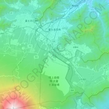
Name: Fujiyoshida topographic map, elevation, terrain.
Location: Fujiyoshida, Yamanashi Prefecture, Chubu Region, Japan (35.36449 138.72759 35.53275 138.86622)
Average elevation: 1,161 m
Minimum elevation: 556 m
Maximum elevation: 3,744 m
Fujiyoshida lies at the northern base of Mount Fuji, and is built upon old lava flows. It is considered a high-elevation city in Japan, at 650 to 850 metres (2,140 to 2,800 feet) above sea level. The city is also located between two of the Fuji Five Lakes. The Katsura River flows through the eastern part of the city.
Other topographic maps
Click on a map to view its topography, its elevation and its terrain.
Motegi
Motegi, Haga County, Tochigi Prefecture, 321-3531, Japan
Average elevation: 145 m
Yamanouchi
Yamanouchi, Shimotakai County, Nagano Prefecture, Chubu Region, Japan
Average elevation: 942 m
Ogawara
Ogawara, Shibata County, Miyagi Prefecture, Japan
Average elevation: 40 m
Kami
Japan > Mikata County > Kami
Kami, Mikata County, Hyogo Prefecture, Japan
Average elevation: 172 m
Okinoshima
Japan > Oki County > Okinoshima
Okinoshima, Oki County, Shimane Prefecture, 6858585, Japan
Average elevation: 10 m
Nakanojo
Japan > Agatsuma County > Nakanojo
Nakanojo, Agatsuma County, Gunma Prefecture, Japan
Average elevation: 882 m
Osaka
Japan > Kinki Region > Osaka
Kita, Osaka, Osaka Prefecture, Kinki Region, Japan
Average elevation: 10 m
Miyashitadori
Japan > Asahikawa > Miyashitadori
Miyashitadori, Asahikawa, Kamikawa Subprefecture, Hokkaido Prefecture, 070-0030, Japan
Average elevation: 118 m