
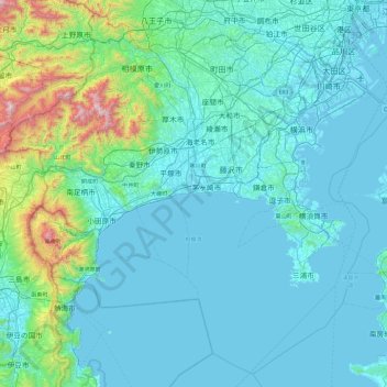
Kanagawa Prefecture topographic map
Interactive map
Click on the map to display elevation.
About this map
Name: Kanagawa Prefecture topographic map, elevation, terrain.
Location: Kanagawa Prefecture, Japan (34.95717 138.91577 35.67290 139.85775)
Average elevation: 170 m
Minimum elevation: -4 m
Maximum elevation: 1,639 m
Topographically, the prefecture consists of three distinct areas. The mountainous western region features the Tanzawa Mountain Range and Hakone Volcano. The hilly eastern region is characterized by the Tama Hills and Miura Peninsula. The central region, which surrounds the Tama Hills and Miura Peninsula, consists of flat stream terraces and low lands around major rivers including the Sagami River, Sakai River, Tsurumi River, and Tama River.
Other topographic maps
Click on a map to view its topography, its elevation and its terrain.
Motegi
Motegi, Haga County, Tochigi Prefecture, 321-3531, Japan
Average elevation: 145 m
Yamanouchi
Yamanouchi, Shimotakai County, Nagano Prefecture, Chubu Region, Japan
Average elevation: 942 m
Ogawara
Ogawara, Shibata County, Miyagi Prefecture, Japan
Average elevation: 40 m
Kami
Japan > Mikata County > Kami
Kami, Mikata County, Hyogo Prefecture, Japan
Average elevation: 172 m
Okinoshima
Japan > Oki County > Okinoshima
Okinoshima, Oki County, Shimane Prefecture, 6858585, Japan
Average elevation: 10 m
Nakanojo
Japan > Agatsuma County > Nakanojo
Nakanojo, Agatsuma County, Gunma Prefecture, Japan
Average elevation: 882 m
Osaka
Japan > Kinki Region > Osaka
Kita, Osaka, Osaka Prefecture, Kinki Region, Japan
Average elevation: 10 m
Miyashitadori
Japan > Asahikawa > Miyashitadori
Miyashitadori, Asahikawa, Kamikawa Subprefecture, Hokkaido Prefecture, 070-0030, Japan
Average elevation: 118 m