
Croatia topographic map
Interactive map
Click on the map to display elevation.
About this map
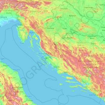
Name: Croatia topographic map, elevation, terrain.
Location: Croatia (42.17660 13.21048 46.55503 19.44727)
Average elevation: 364 m
Minimum elevation: -4 m
Maximum elevation: 2,443 m
The territory covers 56,594 square kilometres (21,851 square miles), consisting of 56,414 square kilometres (21,782 square miles) of land and 128 square kilometres (49 square miles) of water. It is the world's 127th largest country. Elevation ranges from the mountains of the Dinaric Alps with the highest point of the Dinara peak at 1,831 metres (6,007 feet) near the border with Bosnia and Herzegovina in the south to the shore of the Adriatic Sea which makes up its entire southwest border. Insular Croatia consists of over a thousand islands and islets varying in size, 48 of which permanently inhabited. The largest islands are Cres and Krk, each of them having an area of around 405 square kilometres (156 square miles).
Other topographic maps
Click on a map to view its topography, its elevation and its terrain.
Philippines
Philippines
Average elevation: 33 m
Las Vegas
United States > Nevada > Clark County
Las Vegas, Clark County, Nevada, United States
Average elevation: 756 m
Davao City
Philippines > Davao Occidental > Davao City
Davao City, Davao Occidental, Davao Region, Philippines
Average elevation: 303 m
Auckland
Auckland, Waitematā, Auckland, 1010, New Zealand
Average elevation: 32 m
Christchurch
New Zealand > Canterbury > Christchurch City
Christchurch, Christchurch City, Canterbury, New Zealand
Average elevation: 41 m
Dunedin
New Zealand > Otago > Dunedin City
Dunedin, Dunedin City, Otago, 9054, New Zealand
Average elevation: 110 m
Baguio
Philippines > Benguet > Baguio
Baguio, Benguet, Cordillera Administrative Region, 2600, Philippines
Average elevation: 882 m
New Zealand
New Zealand
Average elevation: 399 m
Napier
Napier, Napier City, Hawke's Bay, 4001, New Zealand
Average elevation: 33 m
Wellington
New Zealand > Wellington > Wellington City
Wellington, Wellington City, Wellington, 6011, New Zealand
Average elevation: 85 m
Zwelitsha
South Africa > Eastern Cape > Buffalo City Metropolitan Municipality
Zwelitsha, Buffalo City Metropolitan Municipality, Eastern Cape, South Africa
Average elevation: 251 m
Oxford
United Kingdom > England > Oxfordshire
Oxford, Oxfordshire, England, United Kingdom
Average elevation: 81 m
The Villages
United States > Florida > Sumter County
The Villages, Sumter County, Florida, United States
Average elevation: 25 m
Tagaytay
Philippines > Cavite > Tagaytay > Tagaytay
Tagaytay, Cavite, Calabarzon, 4120, Philippines
Average elevation: 229 m
Tarlac City
Philippines > Tarlac > Tarlac City
Tarlac City, Tarlac, Central Luzon, 2300, Philippines
Average elevation: 56 m
Lucena
Philippines > Quezon > Lucena
Lucena, Quezon, Calabarzon, 4301, Philippines
Average elevation: 144 m
York County
United States of America > Pennsylvania
York County, Pennsylvania, United States of America
Average elevation: 170 m
Donetsk
Donetsk, Donetsk Municipality, Donetsk Oblast, 83000-83490, Ukraine
Average elevation: 196 m
Duvauchelle
New Zealand > Canterbury > Christchurch City > Banks Peninsula Community
Duvauchelle, Banks Peninsula Community, Christchurch City, Canterbury, 7581, New Zealand
Average elevation: 277 m
San Jose del Monte
San Jose del Monte, Bulacan, Central Luzon, 3023, Philippines
Average elevation: 106 m
Damortis
Philippines > La Union > Santo Tomas
Damortis, Santo Tomas, La Union, Ilocos Region, Philippines
Average elevation: 25 m
Lower Hutt
New Zealand > Wellington > Lower Hutt City
Lower Hutt, Lower Hutt City, Wellington, 5040, New Zealand
Average elevation: 173 m
Queenstown
New Zealand > Otago > Queenstown-Lakes District
Queenstown, Queenstown-Lakes District, Otago, 9348, New Zealand
Average elevation: 592 m
Gosford
Australia > New South Wales > Gosford
Gosford, Central Coast Council, New South Wales, 2250, Australia
Average elevation: 25 m
Gulod Labac
Philippines > Batangas > Batangas City
Gulod Labac, Batangas City, Batangas, Calabarzon, 4200, Philippines
Average elevation: 25 m
Santo André
Brazil > São Paulo > Região Metropolitana de São Paulo
Santo André, Região Imediata de São Paulo, Região Metropolitana de São Paulo, Região Geográfica Intermediária de São Paulo, São Paulo, Southeast Region, Brazil
Average elevation: 774 m
Barranquilla
Barranquilla, Atlántico, RAP Caribe, Colombia
Average elevation: 22 m
General Trias
General Trias, Cavite, Calabarzon, 4107, Philippines
Average elevation: 85 m
Pachacámac
Pachacámac, Lurín, Province of Lima, Lima, Peru
Average elevation: 327 m
Royal Tunbridge Wells
United Kingdom > England > Kent > Tunbridge Wells
Royal Tunbridge Wells, Tunbridge Wells, Kent, England, TN1 2DL, United Kingdom
Average elevation: 99 m
Calamba
Philippines > Laguna > Calamba > Calamba
Calamba, Laguna, Calabarzon, 4027, Philippines
Average elevation: 100 m
Detroit
United States > Michigan > Wayne County
Detroit, Wayne County, Michigan, United States
Average elevation: 187 m
Auckland Domain
New Zealand > Auckland > Auckland
Auckland Domain, Parnell, Auckland, Waitematā, Auckland, New Zealand
Average elevation: 49 m
Christchurch City
Christchurch City, Canterbury, New Zealand
Average elevation: 74 m
Big Lake
United States > Texas > Reagan County
Big Lake, Reagan County, Texas, 76932, United States
Average elevation: 820 m
Santo Angel
Philippines > Capiz > Dumalag
Santo Angel, Dumalag, Capiz, Western Visayas, 5813, Philippines
Average elevation: 28 m
Old Bulatukan
Philippines > North Cotabato > Makilala
Old Bulatukan, Makilala, North Cotabato, Soccsksargen, 9401, Philippines
Average elevation: 560 m
Brisbane
Australia > Queensland > Brisbane
Brisbane, Queensland, 4000, Australia
Average elevation: 45 m
Jerusalem
Israel > Jerusalem District > Jerusalem
Jerusalem, Jerusalem District, Israel
Average elevation: 661 m
Invercargill
New Zealand > Southland > Invercargill City > Invercargill
Invercargill, Invercargill City, Southland, 9810, New Zealand
Average elevation: 16 m
Whangārei
New Zealand > Northland > Whangarei District
Whangārei, Whangarei District, Northland, 0110, New Zealand
Average elevation: 96 m