
Malacca topographic map
Interactive map
Click on the map to display elevation.
About this map
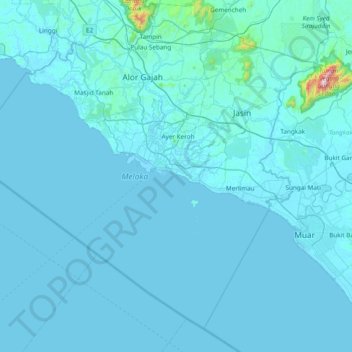
Name: Malacca topographic map, elevation, terrain.
Location: Malacca, Malaysia (1.83953 101.83280 2.49905 102.59438)
Average elevation: 26 m
Minimum elevation: -1 m
Maximum elevation: 1,186 m
The state of Malacca covers an area of 1,664 km2 (642 sq mi). It sits upon the southwestern coast of the Malay Peninsula opposite Sumatra, with the state of Negeri Sembilan to the north and west and Johor to the east. Malacca is situated roughly two-thirds of the way down the west coast, 148 km (92 mi) south of Kuala Lumpur and commands a central position on the Straits of Malacca. With the exception of some of its small hills, Malacca is generally a lowland area with average elevation below 50 meters above sea level.
Other topographic maps
Click on a map to view its topography, its elevation and its terrain.
Taman Muzium Kota Lukut
Malaysia > Negeri Sembilan > Port Dickson
Taman Muzium Kota Lukut, Taman Lukut Lagenda, Lukut, Port Dickson, Negeri Sembilan, Malaysia
Average elevation: 12 m
Skudai
Malaysia > Johor > Iskandar Puteri
Skudai, Iskandar Puteri, Johor Bahru, Iskandar Malaysia, Johor, 81210, Malaysia
Average elevation: 29 m
Sungai Benus
Sungai Benus, Bentong, Pahang, Malaysia
Average elevation: 512 m
Iskandar Puteri
Iskandar Puteri, Johor Bahru, Iskandar Malaysia, Johor, Malaysia
Average elevation: 26 m
Kota Kinabalu
Kota Kinabalu, West Coast Division, Sabah, 88000, Malaysia
Average elevation: 86 m
Pulau Singa Besar
Pulau Singa Besar, Langkawi, Kedah, Malaysia
Average elevation: 26 m
Johor Bahru
Johor Bahru, Iskandar Malaysia, Johor, 80350, Malaysia
Average elevation: 28 m
Section 19
Malaysia > Selangor > SA > Section 19
Section 19, SA, Selangor, 40200, Malaysia
Average elevation: 10 m
Bukit Raya
Bukit Raya, Sri Aman, Sarawak, Malaysia
Average elevation: 130 m
Cameron Highlands
Cameron Highlands, Pahang, 39000, Malaysia
Average elevation: 1,400 m
Kampong Borhan
Malaysia > Kedah > Kampong Borhan
Kampong Borhan, Kota Setar, Kedah, 05460, Malaysia
Average elevation: 5 m
George Town
Malaysia > Penang > George Town
George Town, Northeast Penang Island District, Penang, 10000, Malaysia
Average elevation: 38 m
Kampung Sungai Karang Darat
Malaysia > Pahang > Kampung Sungai Karang Darat
Kampung Sungai Karang Darat, Pahang, 26100, Malaysia
Average elevation: 13 m