
Terengganu topographic map
Interactive map
Click on the map to display elevation.
Terengganu
Terengganu is situated in eastern Peninsular Malaysia, and is bordered in the northwest by Kelantan, the southwest by Pahang, and the east by the South China Sea. The state has a total area of 13,035 km2 (5,033 sq mi). Its topographical profile ranges from relatively level on the coastal east and gradually becoming more hilly and mountainous towards the west, as its western borders are delineated by the Pantai Timur Range, with the highest point being Mount Lawit. The range acts as the main watershed for the state's riverine systems, as it is also home to Lake Kenyir, which is the source of the Terengganu River, the largest man-made lake in the nation and serves as the state's major reservoir. Several outlying islands, including the Perhentians, Kapas and Redang, are also a part of the state.
About this map
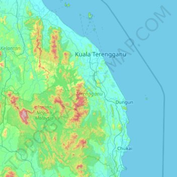
Name: Terengganu topographic map, elevation, terrain.
Location: Terengganu, Malaysia (3.88135 102.37847 5.96413 103.69061)
Average elevation: 127 m
Minimum elevation: -1 m
Maximum elevation: 2,125 m
Other topographic maps
Click on a map to view its topography, its elevation and its terrain.
Mount Kinabalu
Mount Kinabalu (Dusun: Gayo Ngaran or Nulu Nabalu, Malay: Gunung Kinabalu) is the highest mountain in Borneo and Malaysia. With an elevation of 4,095 metres (13,435 ft), it is the third-highest peak of an island on Earth, the 28th highest peak in Southeast Asia, and 20th most prominent mountain in the world.…
Average elevation: 3,567 m
Perak
In 1959, a British artillery officer stationed at an inland army base during the Malayan Emergency discovered the Tambun rock art, identified by archaeologists as the largest rock art site in the Malay Peninsula. Most of the paintings are located high above the cave floor, at an elevation of 6–10 metres…
Average elevation: 251 m
Sabah
The jungles of Sabah host a diverse array of plant and animal species. Most of Sabah's biodiversity is located in the forest reserve areas, which formed half of its total landmass of 7.34 million hectares. Its forest reserve are part of the 20 million hectares equatorial rainforests demarcated under the "Heart…
Average elevation: 115 m
Tambunan
Tambunan (Malay: Pekan Tambunan) is the capital of the Tambunan District in the Interior Division of Sabah, Malaysia. Its population was estimated to be around 35,667 in 2010. It is located 80 kilometres east of the state capital, Kota Kinabalu (to which is connected by the Kota Kinabalu-Tambunan-Keningau…
Average elevation: 697 m
Kuala Lumpur
Located in the centre of Selangor state, Kuala Lumpur was a territory of Selangor State Government. In 1974, Kuala Lumpur was split off from Selangor to form the first Federal Territory governed directly by the Malaysian federal government. Its location in the most developed state on the west coast of…
Average elevation: 80 m
Penang
Penang Island is irregularly shaped, with a hilly and mostly forested interior; its coastal plains are narrow, the most extensive of which is at the northeastern cape. With a height of 833 m (2,733 ft), Penang Hill, at the centre of the island, is the tallest point within Penang. From a small settlement at the…
Average elevation: 18 m
Malacca
The state of Malacca covers an area of 1,664 km2 (642 sq mi). It sits upon the southwestern coast of the Malay Peninsula opposite Sumatra, with the state of Negeri Sembilan to the north and west and Johor to the east. Malacca is situated roughly two-thirds of the way down the west coast, 148 km (92 mi) south…
Average elevation: 26 m