
Montana topographic map
Interactive map
Click on the map to display elevation.
About this map
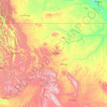
Name: Montana topographic map, elevation, terrain.
Location: Montana, United States (44.35792 -116.04923 49.00253 -104.03956)
Average elevation: 1,357 m
Minimum elevation: 552 m
Maximum elevation: 4,034 m
The state's topography is roughly defined by the Continental Divide, which splits much of the state into distinct eastern and western regions. Most of Montana's hundred or more named mountain ranges are in the state's western half, most of which is geologically and geographically part of the northern Rocky Mountains. The Absaroka and Beartooth ranges in the state's south-central part are technically part of the Central Rocky Mountains. The Rocky Mountain Front is a significant feature in the state's north-central portion, and isolated island ranges that interrupt the prairie landscape common in the central and eastern parts of the state. About 60 percent of the state is prairie, part of the northern Great Plains.
Other topographic maps
Click on a map to view its topography, its elevation and its terrain.
Las Vegas
United States > Nevada > Clark County
Las Vegas, Clark County, Nevada, United States
Average elevation: 756 m
Nashville-Davidson
United States > Tennessee > Davidson County
Nashville-Davidson, Davidson County, Middle Tennessee, Tennessee, United States
Average elevation: 184 m
Skagit County
Skagit County, Washington, United States
Average elevation: 753 m
Franklin County
Franklin County, Middle Tennessee, Tennessee, United States
Average elevation: 349 m
Three Rivers
United States > California > Tulare County
Three Rivers, Tulare County, California, United States
Average elevation: 762 m
The Villages
United States > Florida > Sumter County
The Villages, Sumter County, Florida, United States
Average elevation: 25 m
Williamson County
Williamson County, Texas, United States
Average elevation: 222 m
Little Saint James Island
United States > United States Virgin Islands > Saint Thomas - Saint John District
Little Saint James Island, Saint Thomas - Saint John District, United States Virgin Islands, United States
Average elevation: 1 m
Walsenburg
United States > Colorado > Huerfano County
Walsenburg, Huerfano County, Colorado, United States
Average elevation: 1,899 m
Town of Dryden
United States > New York > Tompkins County
Town of Dryden, Tompkins County, New York, United States
Average elevation: 430 m
Cheatham County
Cheatham County, Middle Tennessee, Tennessee, United States
Average elevation: 189 m
Shaver Lake
United States > California > Fresno County > Shaver Lake
Shaver Lake, Fresno County, California, 93664, United States
Average elevation: 1,437 m
York County
York County, Pennsylvania, United States
Average elevation: 170 m
Grahamville
United States > South Carolina > Jasper County
Grahamville, Jasper County, South Carolina, 29936, United States
Average elevation: 16 m
Three Rivers
United States > Texas > Live Oak County
Three Rivers, Live Oak County, Texas, 78071, United States
Average elevation: 50 m
Palmerville
United States > South Carolina > Berkeley County
Palmerville, Berkeley County, South Carolina, United States
Average elevation: 8 m
Irrigosa
United States > California > Madera County
Irrigosa, Madera County, California, United States
Average elevation: 85 m
Scotland
United States > Pennsylvania > Franklin County > Greene Township
Scotland, Greene Township, Franklin County, Pennsylvania, 17254, United States
Average elevation: 220 m
Weston
United States > Maine > Aroostook County
Weston, Aroostook County, Maine, 04424, United States
Average elevation: 150 m
Littleton
United States > Maine > Aroostook County
Littleton, Aroostook County, Maine, United States
Average elevation: 140 m
Swanson
United States > Ohio > Harrison County
Swanson, Harrison County, Ohio, 43976, United States
Average elevation: 342 m
Waverly
United States > Georgia > Richmond County > Augusta
Waverly, Augusta, Richmond County, Georgia, 30909, United States
Average elevation: 96 m
Hawksbill
United States > Virginia > Madison County
Hawksbill, Madison County, Virginia, United States
Average elevation: 993 m
Ashville
United States > Alabama > St. Clair County
Ashville, St. Clair County, Alabama, 35953, United States
Average elevation: 190 m
Los Gatos
United States > California > Santa Clara County
Los Gatos, Santa Clara County, California, 95030, United States
Average elevation: 209 m
Louisville
United States > Kentucky > Jefferson County
Louisville, Jefferson County, Kentucky, United States
Average elevation: 188 m
Daniels
United States > West Virginia > Raleigh County
Daniels, Raleigh County, West Virginia, United States
Average elevation: 774 m
Lima
United States > Montana > Beaverhead County
Lima, Beaverhead County, Montana, 59739, United States
Average elevation: 1,910 m
Stanardsville
United States > Virginia > Greene County
Stanardsville, Greene County, Virginia, United States
Average elevation: 205 m
Bartlesville
United States > Oklahoma > Washington County
Bartlesville, Washington County, Oklahoma, United States
Average elevation: 231 m
Swansea
United States > South Carolina > Lexington County
Swansea, Lexington County, South Carolina, United States
Average elevation: 117 m
Montrose
United States > Iowa > Lee County
Montrose, Lee County, Iowa, United States
Average elevation: 179 m
Hillcrest
United States > Illinois > Ogle County
Hillcrest, Flagg Township, Ogle County, Illinois, United States
Average elevation: 251 m
South Bend
United States > Indiana > Saint Joseph County
South Bend, Saint Joseph County, Indiana, United States
Average elevation: 236 m
Dallas
United States > Texas > Dallas County
Dallas, Dallas County, Texas, United States
Average elevation: 160 m
Baker
United States > California > Kern County > Boron
Baker, Boron, Kern County, California, United States
Average elevation: 765 m
Prospect Park
United States > New York > New York
Prospect Park, Kings County, New York, United States
Average elevation: 34 m
Atlanta
United States > Georgia > Fulton County
Atlanta, Fulton County, Georgia, United States
Average elevation: 284 m
Village of Bronxville
United States > New York > Westchester County > Town of Eastchester
Village of Bronxville, Town of Eastchester, Westchester County, New York, 10708, United States
Average elevation: 48 m
Grant Grove
United States > California > Fresno County
Grant Grove, Fresno County, California, United States
Average elevation: 1,779 m
Daly City
United States > California > San Mateo County
Daly City, San Mateo County, California, United States
Average elevation: 75 m
Mount Shasta
United States > California > Siskiyou County
Mount Shasta, Siskiyou County, California, United States
Average elevation: 3,717 m
Chino
United States > California > San Bernardino County
Chino, San Bernardino County, California, United States
Average elevation: 239 m
Scotts Valley
United States > California > Santa Cruz County
Scotts Valley, Santa Cruz County, California, 95066, United States
Average elevation: 203 m