
Malaysia topographic map
Interactive map
Click on the map to display elevation.
About this map
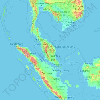
Name: Malaysia topographic map, elevation, terrain.
Location: Malaysia (0.85382 98.73651 8.38015 119.46996)
Average elevation: 54 m
Minimum elevation: -3 m
Maximum elevation: 3,191 m
The two parts of Malaysia, separated from each other by the South China Sea, share a largely similar landscape in that both Peninsular and East Malaysia feature coastal plains rising to hills and mountains. Peninsular Malaysia, containing 40 per cent of Malaysia's land area, extends 740 km (460 mi) from north to south, and its maximum width is 322 km (200 mi). It is divided between its east and west coasts by the Titiwangsa Mountains, rising to a peak elevation of 2,183 metres (7,162 ft) at Mount Korbu, part of a series of mountain ranges running down the centre of the peninsula. These mountains are heavily forested, and mainly composed of granite and other igneous rocks. Much of it has been eroded, creating a karst landscape. The range is the origin of some of Peninsular Malaysia's river systems. The coastal plains surrounding the peninsula reach a maximum width of 50 kilometres (31 mi), and the peninsula's coastline is nearly 1,931 km (1,200 mi) long, although harbours are only available on the western side.
Other topographic maps
Click on a map to view its topography, its elevation and its terrain.
Philippines
Philippines
Average elevation: 33 m
Auckland
Auckland, Waitematā, Auckland, 1010, New Zealand
Average elevation: 32 m
Las Vegas
United States > Nevada > Clark County
Las Vegas, Clark County, Nevada, United States
Average elevation: 756 m
Dunedin
New Zealand > Otago > Dunedin City
Dunedin, Dunedin City, Otago, 9054, New Zealand
Average elevation: 110 m
Wellington
New Zealand > Wellington > Wellington City
Wellington, Wellington City, Wellington, 6011, New Zealand
Average elevation: 85 m
Davao City
Philippines > Davao Occidental > Davao City
Davao City, Davao Occidental, Davao Region, Philippines
Average elevation: 303 m
Tagaytay
Philippines > Cavite > Tagaytay > Tagaytay
Tagaytay, Cavite, Calabarzon, 4120, Philippines
Average elevation: 229 m
Tauranga
New Zealand > Bay of Plenty > Tauranga City
Tauranga, Tauranga City, Bay of Plenty, 3110, New Zealand
Average elevation: 66 m
Baguio
Philippines > Benguet > Baguio
Baguio, Benguet, Cordillera Administrative Region, 2600, Philippines
Average elevation: 882 m
Ocheretyne
Ocheretyne, Ocheretyne settlement hromada, Pokrovskii Raion, Donetsk Oblast, 86020, Ukraine
Average elevation: 227 m
Palmerston North
New Zealand > Palmerston North
Palmerston North, Palmerston North City, Manawatu-Wanganui, 4440, New Zealand
Average elevation: 118 m
Queenstown
New Zealand > Otago > Queenstown-Lakes District
Queenstown, Queenstown-Lakes District, Otago, 9348, New Zealand
Average elevation: 592 m
Christchurch City
Christchurch City, Canterbury, New Zealand
Average elevation: 74 m
Jerusalem
Israel > Jerusalem District > Jerusalem
Jerusalem, Jerusalem District, Israel
Average elevation: 661 m
Invercargill
New Zealand > Southland > Invercargill City > Invercargill
Invercargill, Invercargill City, Southland, 9810, New Zealand
Average elevation: 16 m
Christchurch
New Zealand > Canterbury > Christchurch City
Christchurch, Christchurch City, Canterbury, New Zealand
Average elevation: 41 m
Rangiora
New Zealand > Canterbury > Waimakariri District
Rangiora, Waimakariri District, Canterbury, 7400, New Zealand
Average elevation: 31 m
Brisbane
Australia > Queensland > Brisbane
Brisbane, Queensland, 4000, Australia
Average elevation: 45 m
Auckland Domain
New Zealand > Auckland > Auckland
Auckland Domain, Parnell, Auckland, Waitematā, Auckland, New Zealand
Average elevation: 49 m
San Jose del Monte
San Jose del Monte, Bulacan, Central Luzon, 3023, Philippines
Average elevation: 106 m
York County
York County, Pennsylvania, United States
Average elevation: 170 m
North Shore
New Zealand > Auckland > Kaipātiki
North Shore, Tōtara Vale, Kaipātiki, Auckland, 0629, New Zealand
Average elevation: 57 m
The Villages
United States > Florida > Sumter County
The Villages, Sumter County, Florida, United States
Average elevation: 25 m
New Plymouth
New Zealand > Taranaki > New Plymouth District
New Plymouth, New Plymouth District, Taranaki, 4310, New Zealand
Average elevation: 92 m
Timaru
New Zealand > Canterbury > Timaru District
Timaru, Timaru District, Canterbury, 7910, New Zealand
Average elevation: 16 m
Lower Hutt
New Zealand > Wellington > Lower Hutt City
Lower Hutt, Lower Hutt City, Wellington, 5040, New Zealand
Average elevation: 173 m
Fiji
Fiji
Average elevation: 386 m
Tarlac City
Philippines > Tarlac > Tarlac City
Tarlac City, Tarlac, Central Luzon, 2300, Philippines
Average elevation: 56 m
Gisborne
New Zealand > Gisborne > Gisborne District
Gisborne, Gisborne District, Gisborne, 4010, New Zealand
Average elevation: 70 m
Westland District
Westland District, West Coast, New Zealand
Average elevation: 437 m
Logan City
Australia > Queensland > Logan City
Logan City, Queensland, 4114, Australia
Average elevation: 30 m
Cordillera Blanca
Cordillera Blanca, Municipio de Las Ovejas, Departamento Minas, Neuquén Province, Argentina
Average elevation: 1,926 m
Niugan
Philippines > Batangas > Lemery
Niugan, Lemery, Batangas, Calabarzon, 4209, Philippines
Average elevation: 345 m
General Trias
General Trias, Cavite, Calabarzon, 4107, Philippines
Average elevation: 85 m
Royal Tunbridge Wells
United Kingdom > England > Kent > Tunbridge Wells
Royal Tunbridge Wells, Tunbridge Wells, Kent, England, TN1 2DL, United Kingdom
Average elevation: 99 m
Wānaka
New Zealand > Otago > Queenstown-Lakes District
Wānaka, Queenstown-Lakes District, Otago, 9305, New Zealand
Average elevation: 381 m
Napier
Napier, Napier City, Hawke's Bay, 4001, New Zealand
Average elevation: 33 m