
Chile topographic map
Interactive map
Click on the map to display elevation.
About this map
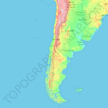
Name: Chile topographic map, elevation, terrain.
Location: Chile (-56.72500 -109.67958 -17.49838 -66.07535)
Average elevation: 193 m
Minimum elevation: -1 m
Maximum elevation: 6,259 m
The Far North is the area between the northern boundary of the country and the parallel 26° S, covering the first three regions. It is characterized by the presence of the Atacama desert, the most arid in the world. The desert is fragmented by streams that originate in the area known as the pampas Tamarugal. The Andes, split in two and whose eastern arm runs through Bolivia, has a high altitude and volcanic activity, which has allowed the formation of the Andean altiplano and salt structures as the Salar de Atacama, due to the gradual accumulation of sediments over time.
Other topographic maps
Click on a map to view its topography, its elevation and its terrain.
Philippines
Philippines
Average elevation: 33 m
Las Vegas
United States > Nevada > Clark County
Las Vegas, Clark County, Nevada, United States
Average elevation: 756 m
Auckland
Auckland, Waitematā, Auckland, 1010, New Zealand
Average elevation: 32 m
Wellington
New Zealand > Wellington > Wellington City
Wellington, Wellington City, Wellington, 6011, New Zealand
Average elevation: 85 m
Dunedin
New Zealand > Otago > Dunedin City
Dunedin, Dunedin City, Otago, 9054, New Zealand
Average elevation: 110 m
Davao City
Philippines > Davao Occidental > Davao City
Davao City, Davao Occidental, Davao Region, Philippines
Average elevation: 303 m
Tauranga
New Zealand > Bay of Plenty > Tauranga City
Tauranga, Tauranga City, Bay of Plenty, 3110, New Zealand
Average elevation: 66 m
Ocheretyne
Ocheretyne, Ocheretyne settlement hromada, Pokrovskii Raion, Donetsk Oblast, 86020, Ukraine
Average elevation: 227 m
Tagaytay
Philippines > Cavite > Tagaytay > Tagaytay
Tagaytay, Cavite, Calabarzon, 4120, Philippines
Average elevation: 229 m
Palmerston North
New Zealand > Palmerston North
Palmerston North, Palmerston North City, Manawatu-Wanganui, 4440, New Zealand
Average elevation: 118 m
Baguio
Philippines > Benguet > Baguio
Baguio, Benguet, Cordillera Administrative Region, 2600, Philippines
Average elevation: 882 m
Jerusalem
Israel > Jerusalem District > Jerusalem
Jerusalem, Jerusalem District, Israel
Average elevation: 661 m
Christchurch
New Zealand > Canterbury > Christchurch City
Christchurch, Christchurch City, Canterbury, New Zealand
Average elevation: 41 m
Invercargill
New Zealand > Southland > Invercargill City > Invercargill
Invercargill, Invercargill City, Southland, 9810, New Zealand
Average elevation: 16 m
Rangiora
New Zealand > Canterbury > Waimakariri District
Rangiora, Waimakariri District, Canterbury, 7400, New Zealand
Average elevation: 31 m
Auckland Domain
New Zealand > Auckland > Auckland
Auckland Domain, Parnell, Auckland, Waitematā, Auckland, New Zealand
Average elevation: 49 m
Christchurch City
Christchurch City, Canterbury, New Zealand
Average elevation: 74 m
San Jose del Monte
San Jose del Monte, Bulacan, Central Luzon, 3023, Philippines
Average elevation: 106 m
York County
York County, Pennsylvania, United States
Average elevation: 170 m
North Shore
New Zealand > Auckland > Kaipātiki
North Shore, Tōtara Vale, Kaipātiki, Auckland, 0629, New Zealand
Average elevation: 57 m
The Villages
United States > Florida > Sumter County
The Villages, Sumter County, Florida, United States
Average elevation: 25 m
Lower Hutt
New Zealand > Wellington > Lower Hutt City
Lower Hutt, Lower Hutt City, Wellington, 5040, New Zealand
Average elevation: 173 m
Queenstown
New Zealand > Otago > Queenstown-Lakes District
Queenstown, Queenstown-Lakes District, Otago, 9348, New Zealand
Average elevation: 592 m
Fiji
Fiji
Average elevation: 386 m
Gisborne
New Zealand > Gisborne > Gisborne District
Gisborne, Gisborne District, Gisborne, 4010, New Zealand
Average elevation: 70 m
Logan City
Australia > Queensland > Logan City
Logan City, Queensland, 4114, Australia
Average elevation: 30 m
Cordillera Blanca
Cordillera Blanca, Municipio de Las Ovejas, Departamento Minas, Neuquén Province, Argentina
Average elevation: 1,926 m
Timaru
New Zealand > Canterbury > Timaru District
Timaru, Timaru District, Canterbury, 7910, New Zealand
Average elevation: 16 m
Niugan
Philippines > Batangas > Lemery
Niugan, Lemery, Batangas, Calabarzon, 4209, Philippines
Average elevation: 345 m
Westland District
Westland District, West Coast, New Zealand
Average elevation: 437 m
Royal Tunbridge Wells
United Kingdom > England > Kent > Tunbridge Wells
Royal Tunbridge Wells, Tunbridge Wells, Kent, England, TN1 2DL, United Kingdom
Average elevation: 99 m
Brisbane
Australia > Queensland > Brisbane
Brisbane, Queensland, 4000, Australia
Average elevation: 45 m
Wānaka
New Zealand > Otago > Queenstown-Lakes District
Wānaka, Queenstown-Lakes District, Otago, 9305, New Zealand
Average elevation: 381 m
Napier
Napier, Napier City, Hawke's Bay, 4001, New Zealand
Average elevation: 33 m
Zakopane
Poland > Lesser Poland Voivodeship > Tatra County
Zakopane, Tatra County, Lesser Poland Voivodeship, Poland
Average elevation: 1,199 m
Cross Roads
Canada > Nova Scotia > Municipality of Colchester
Cross Roads, Municipality of Colchester, Colchester County, Nova Scotia, Canada
Average elevation: 59 m
Batac
Batac, Ilocos Norte, Ilocos Region, 2906, Philippines
Average elevation: 53 m
Pallocan West
Philippines > Batangas > Batangas City
Pallocan West, Batangas City, Batangas, Calabarzon, 4200, Philippines
Average elevation: 16 m