
Zimbabwe topographic map
Interactive map
Click on the map to display elevation.
About this map
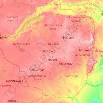
Name: Zimbabwe topographic map, elevation, terrain.
Location: Zimbabwe (-22.42411 25.23730 -15.60970 33.06835)
Average elevation: 869 m
Minimum elevation: 68 m
Maximum elevation: 2,437 m
Zimbabwe is a landlocked country in southern Africa, lying between latitudes 15° and 23°S, and longitudes 25° and 34°E. It is bordered by South Africa to the south, Botswana to the west and southwest, Zambia to the northwest, and Mozambique to the east and northeast. Its northwest corner is roughly 150 meters from Namibia, nearly forming a four-nation quadripoint. Most of the country is elevated, consisting of a central plateau (high veld) stretching from the southwest northwards with altitudes between 1,000 and 1,600 m. The country's extreme east is mountainous, this area being known as the Eastern Highlands, with Mount Nyangani as the highest point at 2,592 m.
Other topographic maps
Click on a map to view its topography, its elevation and its terrain.
Philippines
Philippines
Average elevation: 33 m
Auckland
Auckland, Waitematā, Auckland, 1010, New Zealand
Average elevation: 32 m
Las Vegas
United States > Nevada > Clark County
Las Vegas, Clark County, Nevada, United States
Average elevation: 756 m
Hamilton
New Zealand > Waikato > Hamilton City > Hamilton
Hamilton, Hamilton City, Waikato, 03204, New Zealand
Average elevation: 53 m
Nashville-Davidson
United States > Tennessee > Davidson County
Nashville-Davidson, Davidson County, Middle Tennessee, Tennessee, United States
Average elevation: 184 m
Davao City
Philippines > Davao Occidental > Davao City
Davao City, Davao Occidental, Davao Region, Philippines
Average elevation: 303 m
Tagaytay
Philippines > Cavite > Tagaytay > Tagaytay
Tagaytay, Cavite, Calabarzon, 4120, Philippines
Average elevation: 229 m
Wellington
New Zealand > Wellington > Wellington City
Wellington, Wellington City, Wellington, 6011, New Zealand
Average elevation: 85 m
Tibig
Philippines > Batangas > Lipa
Tibig, Lipa, Batangas, Calabarzon, 4127, Philippines
Average elevation: 353 m
Queenstown
New Zealand > Otago > Queenstown-Lakes District
Queenstown, Queenstown-Lakes District, Otago, 9348, New Zealand
Average elevation: 592 m
Dunedin
New Zealand > Otago > Dunedin City
Dunedin, Dunedin City, Otago, 9054, New Zealand
Average elevation: 110 m
Ban Na Pha Niat
Ban Na Pha Niat, Khao Noi, Wang Phong, Prachuap Khiri Khan Province, 77120, Thailand
Average elevation: 7 m
Baguio
Philippines > Benguet > Baguio
Baguio, Benguet, Cordillera Administrative Region, 2600, Philippines
Average elevation: 882 m
Christchurch City
Christchurch City, Canterbury, New Zealand
Average elevation: 74 m
Pallocan West
Philippines > Batangas > Batangas City
Pallocan West, Batangas City, Batangas, Calabarzon, 4200, Philippines
Average elevation: 16 m
Waiatarua Reserve
New Zealand > Auckland > Orakei
Waiatarua Reserve, Meadowbank, Ōrākei, Auckland, New Zealand
Average elevation: 42 m
Grant Grove
United States > California > Fresno County
Grant Grove, Fresno County, California, United States
Average elevation: 1,779 m
Olecko
Poland > Warmian-Masurian Voivodeship > Olecko County
Olecko, gmina Olecko, Olecko County, Warmian-Masurian Voivodeship, Poland
Average elevation: 170 m
Buayan River
Philippines > Sarangani > Malungon
Buayan River, Malungon, Sarangani, Soccsksargen, 9503, Philippines
Average elevation: 149 m
Kabalasan
Philippines > Leyte > Baybay
Kabalasan, Baybay, 5th District, Leyte, Eastern Visayas, Philippines
Average elevation: 44 m
Havila
Philippines > Rizal > Taytay
Havila, Taytay, Rizal, Calabarzon, 1880, Philippines
Average elevation: 106 m
General Trias
General Trias, Cavite, Calabarzon, 4107, Philippines
Average elevation: 85 m
San Jose del Monte
San Jose del Monte, Bulacan, Central Luzon, 3023, Philippines
Average elevation: 106 m
York County
York County, Pennsylvania, United States
Average elevation: 170 m
Pachacámac
Pachacámac, Lurín, Province of Lima, Lima, Peru
Average elevation: 327 m
Lucena
Philippines > Quezon > Lucena
Lucena, Quezon, Calabarzon, 4301, Philippines
Average elevation: 144 m
The Villages
United States > Florida > Sumter County
The Villages, Sumter County, Florida, United States
Average elevation: 25 m
Sarandi
Sarandi, Região Geográfica Imediata de Carazinho, Região Geográfica Intermediária de Passo Fundo, Rio Grande do Sul, South Region, Brazil
Average elevation: 511 m
Rangiaowhia War Memorial Domain
New Zealand > Waikato > Waipa District > Kihikihi > Rangiaowhia
Rangiaowhia War Memorial Domain, Rangiaowhia, Kihikihi, Waipa District, Waikato, New Zealand
Average elevation: 69 m
Daly City
United States > California > San Mateo County
Daly City, San Mateo County, California, United States
Average elevation: 75 m
Bakakeng Norte
Bakakeng Norte, District 14, Baguio, Cordillera Administrative Region, 2600, Philippines
Average elevation: 1,332 m
Brisbane
Australia > Queensland > Brisbane
Brisbane, Queensland, 4000, Australia
Average elevation: 45 m
Timaru
New Zealand > Canterbury > Timaru District
Timaru, Timaru District, Canterbury, 7910, New Zealand
Average elevation: 16 m
Porirua
New Zealand > Wellington > Porirua City
Porirua, Porirua City, Wellington, 5022, New Zealand
Average elevation: 115 m
New Plymouth
New Zealand > Taranaki > New Plymouth District
New Plymouth, New Plymouth District, Taranaki, 4310, New Zealand
Average elevation: 92 m
Christchurch
New Zealand > Canterbury > Christchurch City
Christchurch, Christchurch City, Canterbury, New Zealand
Average elevation: 41 m
New Zealand
New Zealand
Average elevation: 399 m
Tagum
Tagum, Davao del Norte, Davao Region, 8100, Philippines
Average elevation: 91 m
Abbotsford
Canada > British Columbia > Fraser Valley Regional District
Abbotsford, Fraser Valley Regional District, British Columbia, Canada
Average elevation: 99 m
Mandaui Island
Philippines > Occidental Mindoro > Looc > Ambil
Mandaui Island, Ambil, Looc, Occidental Mindoro, Mimaropa, Philippines
Average elevation: 1 m
Los Altos
Los Altos, Burgos, Castile and León, 09551, Spain
Average elevation: 920 m
Siripura
Sri Lanka > North Central Province
Siripura, Polonnaruwa District, North Central Province, Sri Lanka
Average elevation: 70 m
Narammala
Sri Lanka > North Western Province
Narammala, Kurunegala District, North Western Province, 60100, Sri Lanka
Average elevation: 81 m