
Albania topographic map
Interactive map
Click on the map to display elevation.
About this map
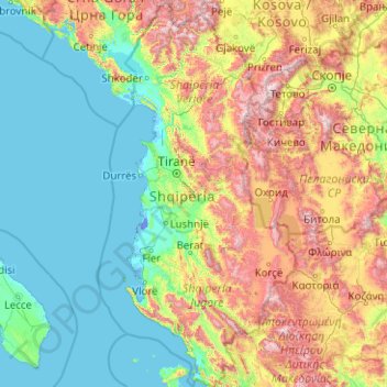
Name: Albania topographic map, elevation, terrain.
Location: Albania (39.64039 19.00099 42.66108 21.05743)
Average elevation: 522 m
Minimum elevation: -7 m
Maximum elevation: 2,633 m
The climate in the country is extremely variable and diverse owing to the differences in latitude, longitude and altitude. Albania experiences predominantly a mediterranean and continental climate, with four distinct seasons. Defined by the Köppen classification, it accommodates five major climatic types ranging from mediterranean and subtropical in the western half to oceanic, continental and subarctic in the eastern half of Albania.
Other topographic maps
Click on a map to view its topography, its elevation and its terrain.
Philippines
Philippines
Average elevation: 33 m
Las Vegas
United States > Nevada > Clark County
Las Vegas, Clark County, Nevada, United States
Average elevation: 756 m
Jerusalem
Israel > Jerusalem District > Jerusalem
Jerusalem, Jerusalem District, Israel
Average elevation: 661 m
Wellington
New Zealand > Wellington > Wellington City
Wellington, Wellington City, Wellington, 6011, New Zealand
Average elevation: 85 m
Dunedin
New Zealand > Otago > Dunedin City
Dunedin, Dunedin City, Otago, 9054, New Zealand
Average elevation: 110 m
Auckland
Auckland, Waitematā, Auckland, 1010, New Zealand
Average elevation: 32 m
Napier
Napier, Napier City, Hawke's Bay, 4001, New Zealand
Average elevation: 33 m
Hamilton
New Zealand > Waikato > Hamilton City > Hamilton
Hamilton, Hamilton City, Waikato, 03204, New Zealand
Average elevation: 53 m
Davao City
Philippines > Davao Occidental > Davao City
Davao City, Davao Occidental, Davao Region, Philippines
Average elevation: 303 m
Tauranga
New Zealand > Bay of Plenty > Tauranga City
Tauranga, Tauranga City, Bay of Plenty, 3110, New Zealand
Average elevation: 66 m
Tagaytay
Philippines > Cavite > Tagaytay > Tagaytay
Tagaytay, Cavite, Calabarzon, 4120, Philippines
Average elevation: 229 m
Christchurch City
Christchurch City, Canterbury, New Zealand
Average elevation: 74 m
New Zealand
New Zealand
Average elevation: 399 m
Porto Velho
Porto Velho, Região Geográfica Imediata de Porto Velho, Região Geográfica Intermediária de Porto Velho, Rondônia, North Region, Brazil
Average elevation: 125 m
San Jose del Monte
San Jose del Monte, Bulacan, Central Luzon, 3023, Philippines
Average elevation: 106 m
Baguio
Philippines > Benguet > Baguio
Baguio, Benguet, Cordillera Administrative Region, 2600, Philippines
Average elevation: 882 m
York County
York County, Pennsylvania, United States
Average elevation: 170 m
Rotorua
New Zealand > Bay of Plenty > Rotorua Lakes District
Rotorua, Rotorua Lakes District, Bay of Plenty, 3010, New Zealand
Average elevation: 435 m
Tibag
Philippines > Occidental Mindoro > Abra de Ilog
Tibag, Abra de Ilog, Occidental Mindoro, Mimaropa, Philippines
Average elevation: 257 m
Hanmer Springs
New Zealand > Canterbury > Hurunui District
Hanmer Springs, Hurunui District, Canterbury, 7334, New Zealand
Average elevation: 490 m
Auckland Domain
New Zealand > Auckland > Auckland
Auckland Domain, Parnell, Auckland, Waitematā, Auckland, New Zealand
Average elevation: 49 m
Christchurch
New Zealand > Canterbury > Christchurch City
Christchurch, Christchurch City, Canterbury, New Zealand
Average elevation: 41 m
Pachacámac
Pachacámac, Lurín, Province of Lima, Lima, Peru
Average elevation: 327 m
Royal Tunbridge Wells
United Kingdom > England > Kent > Tunbridge Wells
Royal Tunbridge Wells, Tunbridge Wells, Kent, England, TN1 2DL, United Kingdom
Average elevation: 99 m
Dalaas
Austria > Vorarlberg > Bezirk Bludenz
Dalaas, Bezirk Bludenz, Vorarlberg, 6752, Austria
Average elevation: 1,681 m
Brisbane
Australia > Queensland > Brisbane
Brisbane, Queensland, 4000, Australia
Average elevation: 45 m
Oxford
United Kingdom > England > Oxfordshire
Oxford, Oxfordshire, England, United Kingdom
Average elevation: 81 m
Timaru
New Zealand > Canterbury > Timaru District
Timaru, Timaru District, Canterbury, 7910, New Zealand
Average elevation: 16 m
Invercargill
New Zealand > Southland > Invercargill City > Invercargill
Invercargill, Invercargill City, Southland, 9810, New Zealand
Average elevation: 16 m
Landayan
Philippines > Laguna > San Pedro
Landayan, San Pedro, Laguna, Calabarzon, 4023, Philippines
Average elevation: 6 m
Magsaysay Park
Magsaysay Park, 27-C Santa Ana, Poblacion, Davao City, Davao Region, 8000, Philippines
Average elevation: 3 m
Silkerode
Germany > Thuringia > Landkreis Eichsfeld > Sonnenstein
Silkerode, Sonnenstein, Landkreis Eichsfeld, Thuringia, Germany
Average elevation: 256 m
Ocheretyne
Ocheretyne, Ocheretyne settlement hromada, Pokrovskii Raion, Donetsk Oblast, 86020, Ukraine
Average elevation: 227 m
Tarlac City
Philippines > Tarlac > Tarlac City
Tarlac City, Tarlac, Central Luzon, 2300, Philippines
Average elevation: 56 m
North Shore
New Zealand > Auckland > Kaipātiki
North Shore, Tōtara Vale, Kaipātiki, Auckland, 0629, New Zealand
Average elevation: 57 m
Calamba
Philippines > Laguna > Calamba > Calamba
Calamba, Laguna, Calabarzon, 4027, Philippines
Average elevation: 100 m
Raqaypata
Peru > Cusco > Santa Teresa
Raqaypata, Santa Teresa, Province of La Convención, Cusco, Peru
Average elevation: 2,972 m
Vincent Community
New Zealand > Otago > Central Otago District
Vincent Community, Central Otago District, Otago, New Zealand
Average elevation: 776 m
Mapandan
Mapandan, Pangasinan, Ilocos Region, 2429, Philippines
Average elevation: 13 m
Zwelitsha
South Africa > Eastern Cape > Buffalo City Metropolitan Municipality
Zwelitsha, Buffalo City Metropolitan Municipality, Eastern Cape, South Africa
Average elevation: 251 m
Lower Hutt
New Zealand > Wellington > Lower Hutt City
Lower Hutt, Lower Hutt City, Wellington, 5040, New Zealand
Average elevation: 173 m
Whanganui
New Zealand > Manawatu-Whanganui > Whanganui District
Whanganui, Whanganui District, Manawatū-Whanganui, 4500, New Zealand
Average elevation: 74 m