
Marokko topographic map
Interactive map
Click on the map to display elevation.
About this map
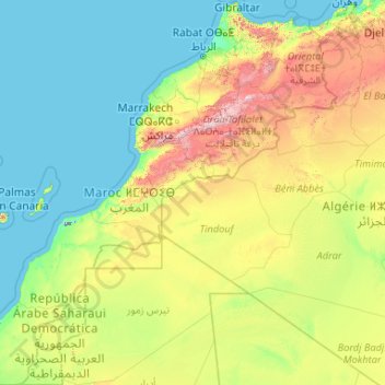
Name: Marokko topographic map, elevation, terrain.
Location: Marokko (21.33346 -17.24484 36.00214 -0.99843)
Average elevation: 371 m
Minimum elevation: -59 m
Maximum elevation: 3,641 m
Das Klima Marokkos zeigt einen Übergang vom mediterran beeinflussten Nordwesten des Landes zum saharisch-kontinentalen Südosten und Süden. Der Hohe und Mittlere Atlas, die zusammen als eigener Klimaraum aufzufassen sind, bilden mit ihrem Hauptkamm die Klimascheide. Der nordwestliche Landesteil hat trockenheiße Sommer mit einer mittleren Augusttemperatur von 23 °C und mittleren Temperaturmaxima zwischen 26 °C (Casablanca) und 29 °C (Tanger). Die Winter sind mild (Januarmittel 12 °C) und regenreich, wobei die Niederschlagsmengen nach Süden hin geringer werden (Tanger 900 mm, Agadir 200 mm Jahresniederschlag). Landeinwärts nimmt der mildernde Einfluss des Meeres rasch ab, so dass in der zentralen Meseta und im Atlasgebirge ausgeprägtes Kontinentalklima herrscht: In Marrakesch (Augustmittel 29 °C) können im Sommer 45 °C erreicht werden, während im Winter die Temperaturen um den Gefrierpunkt liegen können; an Niederschlag fallen kaum 250 mm. Dagegen bringen Steigungsregen an der Westabdachung der Gebirge zum Teil mehr als 1000 mm Niederschlag pro Jahr, der über 1000 m Meereshöhe in den Wintermonaten gewöhnlich als Schnee fällt. In den südlich des Atlas gelegenen Sahara-Randgebieten herrscht extrem trockenheißes Wüstenklima. Es fallen nur unregelmäßig Niederschläge, die selten 200 mm im Jahr erreichen, sodass Ackerbau lediglich in Oasen mit Bewässerung betrieben werden kann. Während der Sommermonate weht zeitweise der Scirocco, ein heißer, staubbeladener Wind aus der Sahara.
Other topographic maps
Click on a map to view its topography, its elevation and its terrain.
Philippines
Philippines
Average elevation: 33 m
Auckland
Auckland, Waitematā, Auckland, 1010, New Zealand
Average elevation: 32 m
Las Vegas
United States > Nevada > Clark County
Las Vegas, Clark County, Nevada, United States
Average elevation: 756 m
Davao City
Philippines > Davao Occidental > Davao City
Davao City, Davao Occidental, Davao Region, Philippines
Average elevation: 303 m
Dunedin
New Zealand > Otago > Dunedin City
Dunedin, Dunedin City, Otago, 9054, New Zealand
Average elevation: 110 m
Christchurch
New Zealand > Canterbury > Christchurch City
Christchurch, Christchurch City, Canterbury, New Zealand
Average elevation: 41 m
Tagaytay
Philippines > Cavite > Tagaytay > Tagaytay
Tagaytay, Cavite, Calabarzon, 4120, Philippines
Average elevation: 229 m
Brisbane
Australia > Queensland > Brisbane
Brisbane, Queensland, 4000, Australia
Average elevation: 45 m
Baguio
Philippines > Benguet > Baguio
Baguio, Benguet, Cordillera Administrative Region, 2600, Philippines
Average elevation: 882 m
Hamilton
New Zealand > Waikato > Hamilton City > Hamilton
Hamilton, Hamilton City, Waikato, 03204, New Zealand
Average elevation: 53 m
Auckland Domain
New Zealand > Auckland > Auckland
Auckland Domain, Parnell, Auckland, Waitematā, Auckland, New Zealand
Average elevation: 49 m
Napier
Napier, Napier City, Hawke's Bay, 4001, New Zealand
Average elevation: 33 m
North Shore
New Zealand > Auckland > Kaipātiki
North Shore, Tōtara Vale, Kaipātiki, Auckland, 0629, New Zealand
Average elevation: 57 m
Cross Roads
Canada > Nova Scotia > Municipality of Colchester
Cross Roads, Municipality of Colchester, Colchester County, Nova Scotia, Canada
Average elevation: 59 m
Pachacámac
Pachacámac, Lurín, Province of Lima, Lima, Peru
Average elevation: 327 m
Batac
Batac, Ilocos Norte, Ilocos Region, 2906, Philippines
Average elevation: 53 m
Tibig
Philippines > Batangas > Lipa
Tibig, Lipa, Batangas, Calabarzon, 4127, Philippines
Average elevation: 353 m
Grant Grove
United States > California > Fresno County
Grant Grove, Fresno County, California, United States
Average elevation: 1,779 m
Ocheretyne
Ocheretyne, Ocheretyne settlement hromada, Pokrovskii Raion, Donetsk Oblast, 86020, Ukraine
Average elevation: 227 m
Jerusalem
Israel > Jerusalem District > Jerusalem
Jerusalem, Jerusalem District, Israel
Average elevation: 661 m
Palmerston North
New Zealand > Palmerston North
Palmerston North, Palmerston North City, Manawatu-Wanganui, 4440, New Zealand
Average elevation: 118 m
Zakopane
Poland > Lesser Poland Voivodeship > Tatra County
Zakopane, Tatra County, Lesser Poland Voivodeship, Poland
Average elevation: 1,199 m
Royal Tunbridge Wells
United Kingdom > England > Kent > Tunbridge Wells
Royal Tunbridge Wells, Tunbridge Wells, Kent, England, TN1 2DL, United Kingdom
Average elevation: 99 m
Calamba
Philippines > Laguna > Calamba > Calamba
Calamba, Laguna, Calabarzon, 4027, Philippines
Average elevation: 100 m
Queenstown
New Zealand > Otago > Queenstown-Lakes District
Queenstown, Queenstown-Lakes District, Otago, 9348, New Zealand
Average elevation: 592 m
Wellington
New Zealand > Wellington > Wellington City
Wellington, Wellington City, Wellington, 6011, New Zealand
Average elevation: 85 m
Nashville-Davidson
United States > Tennessee > Davidson County
Nashville-Davidson, Davidson County, Middle Tennessee, Tennessee, United States
Average elevation: 184 m
Christchurch City
Christchurch City, Canterbury, New Zealand
Average elevation: 74 m
Tarlac City
Philippines > Tarlac > Tarlac City
Tarlac City, Tarlac, Central Luzon, 2300, Philippines
Average elevation: 56 m
Innerfeld
Switzerland > Bern > Interlaken-Oberhasli administrative district > Saxeten
Innerfeld, Saxeten, Interlaken-Oberhasli administrative district, Oberland administrative region, Bern, 3813, Switzerland
Average elevation: 1,555 m
Rotorua
New Zealand > Bay of Plenty > Rotorua Lakes District
Rotorua, Rotorua Lakes District, Bay of Plenty, 3010, New Zealand
Average elevation: 435 m
Pallocan West
Philippines > Batangas > Batangas City
Pallocan West, Batangas City, Batangas, Calabarzon, 4200, Philippines
Average elevation: 16 m
Waiatarua Reserve
New Zealand > Auckland > Orakei
Waiatarua Reserve, Meadowbank, Ōrākei, Auckland, New Zealand
Average elevation: 42 m
The Villages
United States > Florida > Sumter County
The Villages, Sumter County, Florida, United States
Average elevation: 25 m
Whangārei
New Zealand > Northland > Whangarei District
Whangārei, Whangarei District, Northland, 0110, New Zealand
Average elevation: 96 m
Ban Na Pha Niat
Ban Na Pha Niat, Khao Noi, Wang Phong, Prachuap Khiri Khan Province, 77120, Thailand
Average elevation: 7 m
Buayan River
Philippines > Sarangani > Malungon
Buayan River, Malungon, Sarangani, Soccsksargen, 9503, Philippines
Average elevation: 149 m
Kabalasan
Philippines > Leyte > Baybay
Kabalasan, Baybay, 5th District, Leyte, Eastern Visayas, Philippines
Average elevation: 44 m
Havila
Philippines > Rizal > Taytay
Havila, Taytay, Rizal, Calabarzon, 1880, Philippines
Average elevation: 106 m