
Make a donation
Ireland topographic map
Click on the map to display elevation.
Make a donation
Ireland
Ireland's topography is characterized by a central limestone plain, averaging about 75 meters (246 feet) above sea level, interspersed with numerous lakes, bogs, and low ridges. This plain is encircled by coastal mountains of varying geological compositions. In the southwest, the MacGillycuddy's Reeks, composed of old red sandstone, include Carrauntoohil, Ireland's highest peak at 1,038 meters (3,406 feet). The Wicklow Mountains to the east are primarily granite formations, with Lugnaquilla reaching 925 meters (3,035 feet). The north features the basaltic Antrim Plateau and the rugged quartzite peaks of the Donegal Mountains. The coastline is notably rugged and heavily indented along the south and west, where mountain ranges terminate in bold headlands and rocky islands, forming long, narrow fjord-like inlets and wide-mouthed bays. In contrast, the east coast is more uniform, with fewer natural harbors. The River Shannon, Ireland's longest river at approximately 370 kilometers (230 miles), flows south from County Cavan, draining the central plain before emptying into the Atlantic Ocean through a nearly 110-kilometer-long (68 miles) estuary.
Make a donation
About this map
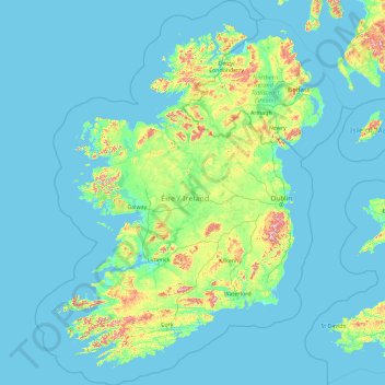
Name: Ireland topographic map, elevation, terrain.
Location: Ireland (51.22200 -11.01338 55.63600 -5.65824)
Average elevation: 44 m
Minimum elevation: -3 m
Maximum elevation: 821 m
Make a donation
Other topographic maps
Click on a map to view its topography, its elevation and its terrain.
Auckland
Auckland’s topography is uniquely shaped by its position on a narrow, undulating isthmus between the Waitematā Harbour to the north and the Manukau Harbour to the south, creating a landscape defined by low coastal plains interrupted by abrupt volcanic relief. The city stands atop the Auckland Volcanic…
Average elevation: 32 m
Washington, D.C.
United States of America > Washington, D.C. > Washington, D.C.
The highest natural elevation in the District is 409 feet (125 m) above sea level at Fort Reno Park in upper northwest Washington. The lowest point is sea level at the Potomac River. The geographic center of Washington is near the intersection of 4th and L Streets NW.
Average elevation: 63 m
Queenstown
New Zealand > Otago > Queenstown-Lakes District
The town is at a relatively low altitude for a ski and snowboarding centre, at 310 metres (1,020 ft) above sea level at the lake shore, but is nestled among mountains, most notably the scenic attraction of The Remarkables, to the town's southeast. Below the lake lies the deep Kawarau Gorge, and there are…
Average elevation: 592 m
Make a donation
Baguio
Philippines > Benguet > Baguio
In 1903, Filipinos, Japanese and Chinese workers were hired to build Kennon Road, the first road directly connecting Baguio with the lowlands of La Union and Pangasinan. Before this, the only road to Benguet was Naguilian Road, and it was largely a horse trail at higher elevations. Camp John Hay was…
Average elevation: 882 m
Make a donation
Kandana Junction
Sri Lanka > Western Province > Madurawala DS Division > Ballapitiya East
Average elevation: 16 m
Make a donation
Dunedin
New Zealand > Otago > Dunedin City
The climate of Dunedin in general is temperate. The city is recognised as having a large number of microclimates and the weather conditions often vary between suburbs mostly due to the city's topographical layout. Under the Köppen climate classification, Dunedin features an oceanic climate. The city's climate…
Average elevation: 110 m
Salt Lake City
United States > Utah > Salt Lake County > Salt Lake City
Salt Lake City has an area of 110.4 square miles (286 km2) and an average elevation of 4,327 feet (1,319 m) above sea level. The lowest point within the boundaries of the city is 4,210 feet (1,280 m) near the Jordan River and the Great Salt Lake, and the highest is Grandview Peak, at 9,410 feet (2,868 m).
Average elevation: 1,625 m
Make a donation
Tagaytay
Philippines > Cavite > Tagaytay > Tagaytay
The southern and eastern portions of Tagaytay are covered by hills and mountains which is generally forests, pine trees and open grasslands. The city lies along Tagaytay Ridge, a ridge stretching about 32 kilometres (20 mi) from Mount Batulao in the west to Mount Sungay in the east with elevations averaging…
Average elevation: 229 m
Antipolo
Its higher elevation than that of Metro Manila affords it a scenic view of the metropolis, especially at night. Its locally grown mangoes and cashews are popular among tourists, as well as suman – a local delicacy made out of glutinous rice. The Hinulugang Taktak National Park, which was once a popular…
Average elevation: 125 m
Make a donation
Wellington
New Zealand > Wellington > Wellington City
Averaging 2,055 hours of sunshine per year, the climate of Wellington is temperate marine, (Köppen: Cfb), generally moderate all year round with warm summers and mild winters, and rarely sees temperatures above 23 °C (73 °F) or below 4 °C (39 °F). The hottest recorded temperature in the city is 31.1 °C…
Average elevation: 85 m
Make a donation
Make a donation
Make a donation
Berlin
Berlin straddles the banks of the River Spree, which flows into the River Havel (a tributary of the River Elbe) in the western borough of Spandau. Among the city's main topographical features are the many lakes in the western and southeastern boroughs formed by the Spree, Havel, and Dahme rivers (the largest…
Average elevation: 47 m
Make a donation
Make a donation
Make a donation
Clark
The development is not a flood-prone area with its minimum elevation being at 54 metres (177 ft) above sea level and its planned central park also serves as a flood catchment basin. The Sierra Madre mountain range is located on the development's east while the Zambales mountain range is located on the west,…
Average elevation: 190 m
Make a donation
Make a donation
Make a donation
San Juan
"San Juan" is a contraction of the city's traditional name of "San Juan del Monte" (lit. 'Saint John of the Mountain'). As with numerous other places in the Philippines, the name combines a patron saint and a toponym; in this case Saint John the Baptist with the locale's hilly terrain and relatively higher…
Average elevation: 35 m
Make a donation
Make a donation
Make a donation
Make a donation
Mishor Adumim
Palestinian Territories > Judea and Samaria > Area C > Maale Adumim
Average elevation: 265 m
Make a donation
Santiago
Chile > Santiago Metropolitan Region > Provincia de Santiago
The city lies in the center of the Santiago Basin, a large bowl-shaped valley consisting of broad and fertile lands surrounded by mountains. The city has a varying elevation, gradually increasing from 400 meters (1,300 feet) in the western areas to more than 700 m (2,297 ft) in the eastern areas. Santiago's…
Average elevation: 722 m
Make a donation
Youbou
Canada > British Columbia > Cowichan Valley Regional District > Area I (Youbou / Meade Creek)
Average elevation: 415 m
Port hills
New Zealand > Canterbury > Christchurch City > Linwood-Central-Heathcote Community
Average elevation: 246 m
Make a donation
Houston
United States > Texas > Harris County > Houston
Houston is located 165 miles (266 km) east of Austin, 88 miles (142 km) west of the Louisiana border, and 250 miles (400 km) south of Dallas. The city has a total area of 637.4 square miles (1,651 km2); this comprises over 599.59 square miles (1,552.9 km2) of land and 22.3 square miles (58 km2) covered by…
Average elevation: 18 m
Marshall Islands
The average altitude above sea level for the entire country is 7 feet (2.1 m).
Average elevation: 0 m
Make a donation
Make a donation
Make a donation
Make a donation