
Sydenham topographic map
Click on the map to display elevation.
Sydenham
In the area where West Hill (later renamed Westwood Hill) and Crystal Palace Park Road raise in elevation and eventually meet, many fine villas were built in the latter half of the nineteenth century. Designed in revival architectural styles, fashionable at the time, most of the properties were three or four stories high and large enough to attract more affluent residents. UK Census records suggest that many employed one or more live-in domestic staff. One of the more unusual residential streets, due to its circular arrangement is Charleville Circus, subject of an in-depth One-place study. Upper Sydenham is also the location of the Sydenham Park allotments, the Sydenham electricity sub station which had a major fire in 2008 and the Sydenham Hill estate.
About this map
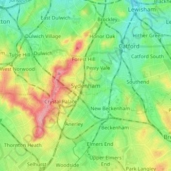
Name: Sydenham topographic map, elevation, terrain.
Location: Sydenham, Greater London, England, SE26 4PN, United Kingdom (51.38677 -0.09239 51.46677 -0.01239)
Average elevation: 45 m
Minimum elevation: 6 m
Maximum elevation: 119 m
Other topographic maps
Click on a map to view its topography, its elevation and its terrain.
Dartmoor National Park
United Kingdom > England > Devon
Rainfall tends to be associated with Atlantic depressions or with convection. In summer, convection caused by solar surface heating sometimes forms shower clouds and a large proportion of rainfall falls from showers and thunderstorms at this time of year. The wettest months are November and December and on the…
Average elevation: 239 m
Lincoln
United Kingdom > England > Lincolnshire
Lincoln lies at an altitude of 67 ft (20.4 m) by the River Witham up to 246 ft (75.0 m) on Castle Hill. It fills a gap in the Lincoln Cliff escarpment, which runs north and south through Central Lincolnshire, with altitudes up to 200 feet (61 metres). The city lies on the River Witham, which flows through this…
Average elevation: 29 m
Leicestershire
A large part of the north-west of the county, around Coalville, forms part of the new National Forest area extending into Derbyshire and Staffordshire. The highest point of the county is Bardon Hill at 278 m (912 ft), which is also a Marilyn; with other hilly/upland areas of c. 150–200 metres (490–660 ft)…
Average elevation: 97 m
Buxton
United Kingdom > England > Derbyshire > High Peak
Buxton has an oceanic climate with short, mild summers and long, cool winters. At about 1,000 feet (300 m) above sea level, Buxton is the highest market town in England. Buxton's elevation makes it cooler and wetter than surrounding towns, with a daytime temperature typically about 2 °C lower than Manchester.
Average elevation: 334 m
Sleaford
United Kingdom > England > Lincolnshire > North Kesteven
The town centre lies about 49 feet (15 m) above sea level and has formed around the River Slea, which runs west to north-east through it. A band of Jurassic Cornbrash limestone forms the bedrock under Holdingham (where the ground rises to 82 feet (25 m) above sea level in places), parts of central Sleaford,…
Average elevation: 18 m
Ludlow
United Kingdom > England > Shropshire
During the 12th century, the planned town of Ludlow was formed, in stages, the town providing a useful source of income for successive Marcher Lords, based on rents, fines, and tolls. They developed the town on a regular grid pattern, although this was adapted somewhat to match the local topography, from the…
Average elevation: 108 m
Crawley
United Kingdom > England > West Sussex
Crawley lies within the Sussex Weald, an area of highly variable terrain so that many microclimates of frost hollows, sun traps and windswept hilltops will be encountered over a short distance. During calm, clear periods of weather this allows for some interesting temperature variations, although most of the…
Average elevation: 80 m
Lickey Hills Country Park
United Kingdom > England > Worcestershire > Bromsgrove > Cofton Hackett CP
The visitor centre, which first opened in April 1990, contains an exhibition, leaflets and information on nature trails, guided walks and other activities organised by the Ranger Service. It also has a small café and gift shop. There are three car parks, one for the visitor centre, one by the golf club house…
Average elevation: 208 m
Derbyshire
Because of its central location in England and altitude range from 27 metres in the south to 636 metres in the north, Derbyshire contains many species at the edge of their UK distribution ranges. Some species with a predominantly northern British distribution are at the southern limit of their range, whilst…
Average elevation: 144 m
Daglingworth
United Kingdom > England > Gloucestershire > Cotswold District > Daglingworth
Average elevation: 169 m
Suffolk
The west of the county lies on more resistant Cretaceous chalk. This chalk is responsible for a sweeping tract of largely downland landscapes that stretches from Dorset in the south west to Dover in the south east and north through East Anglia to the Yorkshire Wolds. The chalk is less easily eroded so forms…
Average elevation: 35 m
Plymouth
The River Plym, which flows off Dartmoor to the north-east, forms a smaller estuary to the east of the city called Cattewater. Plymouth Sound is protected from the sea by the Plymouth Breakwater, in use since 1814. In the Sound is Drake's Island which is seen from Plymouth Hoe, a flat public area on top of…
Average elevation: 46 m
Shrewsbury
United Kingdom > England > Shropshire
The town centre is partially built on a hill whose elevation is, at its highest, 246 feet (75 m) above sea level. The longest river in the United Kingdom, the River Severn, flows through the town, forming a meander around its centre. The Rea Brook is a small river that has its confluence with the Severn at…
Average elevation: 69 m
Marlborough
United Kingdom > England > Wiltshire > Marlborough
Marlborough has an oceanic climate somewhat influenced by its inland position and at 407 feet (124 m) elevation is more prone to frost than southern coastal areas. For example, in 1909 the town reported the equal lowest temperature in the UK at a station below 1,600 feet (500 m) for that year, with a…
Average elevation: 163 m
Borough of Wokingham
Elevations range between 30 and 70 metres above sea level except higher in about 5% of the borough. The highest is an escarpment containing parts of the rural and wooded northern area, the hinterland of three Thames-side villages, facing the 30-mile long Chilterns AONB, west and north. A geological part of…
Average elevation: 66 m
Haslemere
United Kingdom > England > Surrey > Waverley
Many of the roads in the area originated as medieval tracks and owing to the local topography, are narrow, twisting and steep. The principal route through Haslemere is the A286, which connects the town with Godalming and Grayswood (to the north) and with Midhurst (to the south). The A287 runs south from…
Average elevation: 150 m