
United Kingdom topographic map
Interactive map
Click on the map to display elevation.
United Kingdom
The United Kingdom (UK) boasts a diverse topography, ranging from rugged highlands to gentle lowlands. In Scotland, the Highlands dominate the northern and western regions, featuring mountainous terrains with peaks like Ben Nevis, the UK's highest point at 1,345 meters (4,413 feet). The Central Lowlands, including the valleys of the Tay, Forth, and Clyde rivers, offer flatter landscapes. Wales is predominantly mountainous, especially in the north and central areas, with the Cambrian Mountains and Snowdonia National Park housing peaks such as Snowdon at 1,085 meters (3,560 feet). England's topography is characterized by the Pennines, often referred to as the "backbone of England," running north to south, and the Lake District in the northwest, home to Scafell Pike, the highest point in England at 978 meters (3,209 feet). Northern Ireland features the Mourne Mountains in the southeast, with Slieve Donard reaching 852 meters (2,795 feet), and the expansive Lough Neagh, the largest lake in the UK. The UK's varied terrain, including extensive coastlines, rolling hills, and fertile plains, contributes to its rich natural beauty and ecological diversity.
About this map
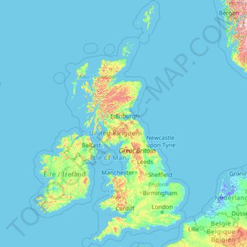
Name: United Kingdom topographic map, elevation, terrain.
Location: United Kingdom (49.67400 -14.01552 61.06100 2.09191)
Average elevation: 42 m
Minimum elevation: -6 m
Maximum elevation: 1,617 m
Other topographic maps
Click on a map to view its topography, its elevation and its terrain.
Auckland
The Auckland Volcanic Field has contributed greatly to the growth and prosperity of the Auckland Region since the area was settled by humans. Initially, the maunga (scoria cones) were occupied and established as pā (fortified settlements) by Māori due to the strategic advantage their elevation provided in…
Average elevation: 32 m
Clark
The development is not a flood-prone area with its minimum elevation being at 54 metres (177 ft) above sea level and its planned central park also serves as a flood catchment basin. The Sierra Madre mountain range is located on the development's east while the Zambales mountain range is located on the west,…
Average elevation: 190 m
Antipolo
Its higher elevation than that of Metro Manila affords it a scenic view of the metropolis, especially at night. Its locally grown mangoes and cashews are popular among tourists, as well as suman – a local delicacy made out of glutinous rice. The Hinulugang Taktak National Park, which was once a popular…
Average elevation: 125 m
Wellington
New Zealand > Wellington > Wellington City
Averaging 2,055 hours of sunshine per year, the climate of Wellington is temperate marine, (Köppen: Cfb), generally moderate all year round with warm summers and mild winters, and rarely sees temperatures above 23 °C (73 °F) or below 4 °C (39 °F). The hottest recorded temperature in the city is 31.1 °C…
Average elevation: 85 m
Baguio
Philippines > Benguet > Baguio
In 1903, Filipinos, Japanese and Chinese workers were hired to build Kennon Road, the first road directly connecting Baguio with the lowlands of La Union and Pangasinan. Before this, the only road to Benguet was Naguilian Road, and it was largely a horse trail at higher elevations. Camp John Hay was…
Average elevation: 882 m
Tagaytay
Philippines > Cavite > Tagaytay > Tagaytay
The southern and eastern portions of Tagaytay are covered by hills and mountains which is generally forests, pine trees and open grasslands. The city lies along Tagaytay Ridge, a ridge stretching about 32 kilometres (20 mi) from Mount Batulao in the west to Mount Sungay in the east with elevations averaging…
Average elevation: 229 m
Dunedin
New Zealand > Otago > Dunedin City
The climate of Dunedin in general is temperate. The city is recognised as having a large number of microclimates and the weather conditions often vary between suburbs mostly due to the city's topographical layout. Under the Köppen climate classification, Dunedin features an oceanic climate. The city's climate…
Average elevation: 110 m
San Jose del Monte
The elevation of the city ranges from approximately 40 to 900 meters (130 to 2,950 ft) above sea level; the relief transitions from warm lowland to cool upland as one goes eastward. This is because the city is part of the Sierra Madre mountain range. Plains and river valley flats characterize the western and…
Average elevation: 106 m
Albuquerque
United States > New Mexico > Bernalillo County
Albuquerque is located in north-central New Mexico. To its east are the Sandia–Manzano Mountains. The Rio Grande flows north to south through its center, while the West Mesa and Petroglyph National Monument make up the western part of the city. Albuquerque has one of the highest elevations of any major city…
Average elevation: 1,671 m
Kampung Indian Settlement Batu Caves
Malaysia > Selangor > Selayang Municipal Council > Batu Caves
Average elevation: 68 m
Washington, D.C.
United States of America > Washington, D.C. > Washington, D.C.
The highest natural elevation in the District is 409 feet (125 m) above sea level at Fort Reno Park in upper northwest Washington. The lowest point is sea level at the Potomac River. The geographic center of Washington is near the intersection of 4th and L Streets NW.
Average elevation: 63 m
Queenstown
New Zealand > Queenstown-Lakes District
The town is at a relatively low altitude for a ski and snowboarding centre, at 310 metres (1,020 ft) above sea level at the lake shore, but is nestled among mountains, most notably the scenic attraction of The Remarkables, to the town's southeast. Below the lake lies the deep Kawarau Gorge, and there are…
Average elevation: 592 m
Berlin
Berlin straddles the banks of the River Spree, which flows into the River Havel (a tributary of the River Elbe) in the western borough of Spandau. Among the city's main topographical features are the many lakes in the western and southeastern boroughs formed by the Spree, Havel, and Dahme rivers (the largest…
Average elevation: 47 m
Grand Ethiopian Renaissance Dam
Ethiopia > Benishangul-Gumuz Region
The first phase of filling the reservoir began in July 2020 and in August 2020 the water level rose to an altitude of 540 meters (40 meters higher than the bottom of the river, which is at an altitude of 500 meters above sea level). The second phase of filling was completed on 19 July 2021, with water levels…
Average elevation: 555 m
Siliguri
India > West Bengal > Siliguri Subdivsion
Siliguri is located at the foothills of the eastern Himalayas at a location of 26°43′N 88°26′E / 26.71°N 88.43°E / 26.71; 88.43. The city is spread over an area of 260 km2 (100 sq mi) within the Siliguri Corridor. The city is bordered by dense forests to the north and the Mahananda River flows…
Average elevation: 121 m
Auckland Domain
New Zealand > Auckland > Auckland
During the 2023 Auckland Anniversary Weekend floods, a lake reformed in the lower elevation area of Pukekawa / Auckland Domain that was once a wetland.
Average elevation: 49 m