
United Kingdom topographic map
Interactive map
Click on the map to display elevation.
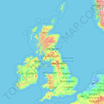
United Kingdom topographic map, elevation, terrain
United Kingdom
Scotland accounts for just under one-third (32 per cent) of the total area of the UK, covering 78,772 square kilometres (30,410 sq mi). This includes nearly 800 islands, predominantly west and north of the mainland; notably the Hebrides, Orkney Islands and Shetland Islands. Scotland is the most mountainous country in the UK and its topography is distinguished by the Highland Boundary Fault – a geological rock fracture – which traverses Scotland from Arran in the west to Stonehaven in the east. The fault separates two distinctively different regions; namely the Highlands to the north and west and the Lowlands to the south and east. The more rugged Highland region contains the majority of Scotland's mountainous land, including Ben Nevis which at 1,345 metres (4,413 ft) is the highest point in the British Isles. Lowland areas – especially the narrow waist of land between the Firth of Clyde and the Firth of Forth known as the Central Belt – are flatter and home to most of the population including Glasgow, Scotland's largest city, and Edinburgh, its capital and political centre, although upland and mountainous terrain lies within the Southern Uplands.
About this map
Name: United Kingdom topographic map, elevation, terrain.
Location: United Kingdom (49.67400 -14.01552 61.06100 2.09191)
Average elevation: 42 m
Minimum elevation: -6 m
Maximum elevation: 1,617 m
Other topographic maps
Click on a map to view its topography, its elevation and its terrain.
Philippines
The average yearly temperature is around 26.6 °C (79.9 °F). In considering temperature, location in terms of latitude and longitude is not a significant factor, and temperatures at sea level tend to be in the same range. Altitude usually has more of an impact. The average annual temperature of Baguio at an…
Average elevation: 33 m
Auckland
The Auckland Volcanic Field has contributed greatly to the growth and prosperity of the Auckland Region since the area was settled by humans. Initially, the maunga (scoria cones) were occupied and established as pā (fortified settlements) by Māori due to the strategic advantage their elevation provided in…
Average elevation: 32 m
Las Vegas
United States > Nevada > Clark County
The peaks surrounding Las Vegas reach elevations of over 10,000 feet (3,000 m), and act as barriers to the strong flow of moisture from the surrounding area. The elevation is approximately 2,030 ft (620 m) above sea level. According to the United States Census Bureau, the city has a total area of 135.86 sq mi…
Average elevation: 756 m
District of Columbia
The highest natural elevation in the District is 409 feet (125 m) above sea level at Fort Reno Park in upper northwest Washington. The lowest point is sea level at the Potomac River. The geographic center of Washington is near the intersection of 4th and L Streets NW.
Average elevation: 49 m
Wellington
New Zealand > Wellington > Wellington City
Averaging 2,055 hours of sunshine per year, the climate of Wellington is temperate marine, (Köppen: Cfb), generally moderate all year round with warm summers and mild winters, and rarely sees temperatures above 23 °C (73 °F) or below 4 °C (39 °F). The hottest recorded temperature in the city is 31.1 °C…
Average elevation: 85 m
Metro Manila
The Coastal Margin or Lowland is a flat and low plain that faces Manila Bay. Located here is Manila, Navotas, parts of Malabon, and the western part and reclaimed areas of Pasay and Parañaque, where the ground elevation ranges from zero meters on Manila Bay to five meters at the west side of the cities of…
Average elevation: 43 m
Tennessee
The average elevation of the Blue Ridge area is 5,000 feet (1,500 m) above sea level. Clingmans Dome, the state's highest point, is located in this region. The Blue Ridge area was never more than sparsely populated, and today much of it is protected by the Cherokee National Forest, the Great Smoky Mountains…
Average elevation: 233 m
Antipolo
Its higher elevation than that of Metro Manila affords it a scenic view of the metropolis, especially at night. Its locally grown mangoes and cashews are popular among tourists, as well as suman – a local delicacy made out of glutinous rice. The Hinulugang Taktak National Park, which was once a popular…
Average elevation: 125 m
Baguio
Philippines > Benguet > Baguio
In 1903, Filipinos, Japanese and Chinese workers were hired to build Kennon Road, the first road directly connecting Baguio with the lowlands of La Union and Pangasinan. Before this, the only road to Benguet was Naguilian Road, and it was largely a horse trail at higher elevations. Camp John Hay was…
Average elevation: 882 m
Queenstown
New Zealand > Otago > Queenstown-Lakes District
The town is at a relatively low altitude for a ski and snowboarding centre, at 310 metres (1,020 ft) above sea level at the lake shore, but is nestled among mountains, most notably the scenic attraction of The Remarkables, to the town's southeast. Below the lake lies the deep Kawarau Gorge, and there are…
Average elevation: 592 m
Pau
France > Nouvelle-Aquitaine > Pyrénées-Atlantiques
The city, located at an average altitude of 200 metres (660 ft), is crossed by the Gave de Pau, where a ford gave passage to the Pyrenees. Gave is the name given to a torrent in the Pyrenees. The Gave de Pau, which becomes a torrent when mountain snow melts, takes its source in the Cirque de Gavarnie and is…
Average elevation: 205 m
Tagaytay
Philippines > Cavite > Tagaytay > Tagaytay
The southern and eastern portions of Tagaytay are covered by hills and mountains which is generally forests, pine trees and open grasslands. The city lies along Tagaytay Ridge, a ridge stretching about 32 kilometres (20 mi) from Mount Batulao in the west to Mount Sungay in the east with elevations averaging…
Average elevation: 229 m
San Jose del Monte
The elevation of the city ranges from approximately 40 to 900 meters (130 to 2,950 ft) above sea level; the relief transitions from warm lowland to cool upland as one goes eastward. This is because the city is part of the Sierra Madre mountain range. Plains and river valley flats characterize the western and…
Average elevation: 106 m
Auckland
The Auckland Volcanic Field has contributed greatly to the growth and prosperity of the Auckland Region since the area was settled by humans. Initially, the maunga (scoria cones) were occupied and established as pā (fortified settlements) by Māori due to the strategic advantage their elevation provided in…
Average elevation: 30 m
Napier
The city is on Napier Hill and the surrounding Heretaunga Plains at the southeastern edge of Hawke Bay, a large semi-circular bay that dominates the east coast of New Zealand's North Island. The coastline of the city was substantially altered by a large earthquake in 1931. The topography puts Napier in danger…
Average elevation: 12 m
Dunedin
New Zealand > Otago > Dunedin City
The climate of Dunedin in general is temperate. The city is recognised as having a large number of microclimates and the weather conditions often vary between suburbs mostly due to the city's topographical layout. Under the Köppen climate classification, Dunedin features an oceanic climate. The city's climate…
Average elevation: 110 m
New Zealand
New Zealand (Māori: Aotearoa [aɔˈtɛaɾɔa]) is an island country in the southwestern Pacific Ocean. It consists of two main landmasses—the North Island (Te Ika-a-Māui) and the South Island (Te Waipounamu)—and over 700 smaller islands. It is the sixth-largest island country by area, covering 268,021…
Average elevation: 399 m
Quezon City
In order to make Quezon's dream a reality and to mobilize funds for the land purchase, the People's Homesite Corporation (PHC) was created on October 14, 1938, as a subsidiary of NDC, with an initial capital of ₱2 million. Roces was the chairman of the Board of PHC, and they immediately acquired the vast…
Average elevation: 39 m
Calabanga
The topographic landscape of the municipality could be characterized as generally flat with a slope 0-3%, gently sloping (3-8%) towards the direction of the eastern portion and finally rolling up to higher steeps towards the direction of the south-eastern part going to Mt. Isarog. The 0-3% slope is a broad…
Average elevation: 11 m
Hanmer Springs
New Zealand > Canterbury > Hurunui District
The Jacks Pass – Clarence River – Jollies Pass Loop is a 25 kilometer loop which is not technically challenging however it takes between two to four hours to complete. It can be ridden in either direction: West over Jacks Pass (869m) or East over Jollies Pass (850m). As the entire ride is at high elevation…
Average elevation: 490 m
Marlborough
United Kingdom > England > Wiltshire > Marlborough
Marlborough has an oceanic climate somewhat influenced by its inland position and at 407 feet (124 m) elevation is more prone to frost than southern coastal areas. For example, in 1909 the town reported the equal lowest temperature in the UK at a station below 1,600 feet (500 m) for that year, with a…
Average elevation: 163 m