
United Kingdom topographic map
Interactive map
Click on the map to display elevation.
About this map
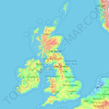
Name: United Kingdom topographic map, elevation, terrain.
Location: United Kingdom (49.67400 -14.01552 61.06100 2.09191)
Average elevation: 42 m
Minimum elevation: -6 m
Maximum elevation: 1,617 m
Scotland accounts for just under one-third (32 per cent) of the total area of the UK, covering 78,772 square kilometres (30,410 sq mi). This includes nearly 800 islands, predominantly west and north of the mainland; notably the Hebrides, Orkney Islands and Shetland Islands. Scotland is the most mountainous country in the UK and its topography is distinguished by the Highland Boundary Fault – a geological rock fracture – which traverses Scotland from Arran in the west to Stonehaven in the east. The fault separates two distinctively different regions; namely the Highlands to the north and west and the Lowlands to the south and east. The more rugged Highland region contains the majority of Scotland's mountainous land, including Ben Nevis which at 1,345 metres (4,413 ft) is the highest point in the British Isles. Lowland areas – especially the narrow waist of land between the Firth of Clyde and the Firth of Forth known as the Central Belt – are flatter and home to most of the population including Glasgow, Scotland's largest city, and Edinburgh, its capital and political centre, although upland and mountainous terrain lies within the Southern Uplands.
Other topographic maps
Click on a map to view its topography, its elevation and its terrain.
Philippines
Philippines
Average elevation: 33 m
Auckland
Auckland, Waitematā, Auckland, 1010, New Zealand
Average elevation: 32 m
Tagaytay
Philippines > Cavite > Tagaytay > Tagaytay
Tagaytay, Cavite, Calabarzon, 4120, Philippines
Average elevation: 229 m
Las Vegas
United States > Nevada > Clark County
Las Vegas, Clark County, Nevada, United States
Average elevation: 756 m
Davao City
Philippines > Davao Occidental > Davao City
Davao City, Davao Occidental, Davao Region, Philippines
Average elevation: 303 m
Dunedin
New Zealand > Otago > Dunedin City
Dunedin, Dunedin City, Otago, 9054, New Zealand
Average elevation: 110 m
Wellington
New Zealand > Wellington > Wellington City
Wellington, Wellington City, Wellington, 6011, New Zealand
Average elevation: 85 m
Queenstown
New Zealand > Otago > Queenstown-Lakes District
Queenstown, Queenstown-Lakes District, Otago, 9348, New Zealand
Average elevation: 592 m
San Jose del Monte
San Jose del Monte, Bulacan, Central Luzon, 3023, Philippines
Average elevation: 106 m
Lower Hutt
New Zealand > Wellington > Lower Hutt City
Lower Hutt, Lower Hutt City, Wellington, 5040, New Zealand
Average elevation: 173 m
Christchurch
New Zealand > Canterbury > Christchurch City
Christchurch, Christchurch City, Canterbury, New Zealand
Average elevation: 41 m
Christchurch City
Christchurch City, Canterbury, New Zealand
Average elevation: 74 m
Brisbane
Australia > Queensland > Brisbane
Brisbane, Queensland, 4000, Australia
Average elevation: 45 m
Old Bulatukan
Philippines > North Cotabato > Makilala
Old Bulatukan, Makilala, North Cotabato, Soccsksargen, 9401, Philippines
Average elevation: 560 m
Tauranga
New Zealand > Bay of Plenty > Tauranga City
Tauranga, Tauranga City, Bay of Plenty, 3110, New Zealand
Average elevation: 66 m
Pachacámac
Pachacámac, Lurín, Province of Lima, Lima, Peru
Average elevation: 327 m
Baguio
Philippines > Benguet > Baguio
Baguio, Benguet, Cordillera Administrative Region, 2600, Philippines
Average elevation: 882 m
Whangārei
New Zealand > Northland > Whangarei District
Whangārei, Whangarei District, Northland, 0110, New Zealand
Average elevation: 96 m
The Villages
United States > Florida > Sumter County
The Villages, Sumter County, Florida, United States
Average elevation: 25 m
Auckland Domain
New Zealand > Auckland > Auckland
Auckland Domain, Parnell, Auckland, Waitematā, Auckland, New Zealand
Average elevation: 49 m
Barranquilla
Barranquilla, Atlántico, RAP Caribe, Colombia
Average elevation: 22 m
Tarlac City
Philippines > Tarlac > Tarlac City
Tarlac City, Tarlac, Central Luzon, 2300, Philippines
Average elevation: 56 m
Calamba
Philippines > Laguna > Calamba > Calamba
Calamba, Laguna, Calabarzon, 4027, Philippines
Average elevation: 100 m
Duvauchelle
New Zealand > Canterbury > Christchurch City > Banks Peninsula Community
Duvauchelle, Banks Peninsula Community, Christchurch City, Canterbury, 7581, New Zealand
Average elevation: 277 m
Damortis
Philippines > La Union > Santo Tomas
Damortis, Santo Tomas, La Union, Ilocos Region, Philippines
Average elevation: 25 m
Invercargill
New Zealand > Southland > Invercargill City > Invercargill
Invercargill, Invercargill City, Southland, 9810, New Zealand
Average elevation: 16 m
Gosford
Australia > New South Wales > Gosford
Gosford, Central Coast Council, New South Wales, 2250, Australia
Average elevation: 25 m
Gulod Labac
Philippines > Batangas > Batangas City
Gulod Labac, Batangas City, Batangas, Calabarzon, 4200, Philippines
Average elevation: 25 m
Santo André
Brazil > São Paulo > Região Metropolitana de São Paulo
Santo André, Região Imediata de São Paulo, Região Metropolitana de São Paulo, Região Geográfica Intermediária de São Paulo, São Paulo, Southeast Region, Brazil
Average elevation: 774 m
General Trias
General Trias, Cavite, Calabarzon, 4107, Philippines
Average elevation: 85 m
Detroit
United States > Michigan > Wayne County
Detroit, Wayne County, Michigan, United States
Average elevation: 187 m
Big Lake
United States > Texas > Reagan County
Big Lake, Reagan County, Texas, 76932, United States
Average elevation: 820 m
Santo Angel
Philippines > Capiz > Dumalag
Santo Angel, Dumalag, Capiz, Western Visayas, 5813, Philippines
Average elevation: 28 m
New Zealand
New Zealand
Average elevation: 399 m
Jerusalem
Israel > Jerusalem District > Jerusalem
Jerusalem, Jerusalem District, Israel
Average elevation: 661 m
Napier
Napier, Napier City, Hawke's Bay, 4001, New Zealand
Average elevation: 33 m
Meridian
United States > Mississippi > Lauderdale County
Meridian, Lauderdale County, Mississippi, United States
Average elevation: 118 m
Westmorland
United States > California > Imperial County
Westmorland, Imperial County, California, United States
Average elevation: -51 m
Dayap Itaas
Philippines > Batangas > Laurel
Dayap Itaas, Laurel, Batangas, Calabarzon, Philippines
Average elevation: 503 m
Hayling Island
United Kingdom > England > Hampshire > Havant > North Hayling
Hayling Island, North Hayling, Havant, Hampshire, England, United Kingdom
Average elevation: 1 m