
Nepal topographic map
Interactive map
Click on the map to display elevation.
About this map
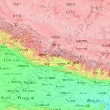
Name: Nepal topographic map, elevation, terrain.
Location: Nepal (26.34776 80.05708 30.47149 88.20153)
Average elevation: 2,612 m
Minimum elevation: 21 m
Maximum elevation: 8,152 m
Nepal is divided into three principal physiographic belts known as Himal–Pahad–Terai. Himal is the mountain region containing snow and situated in the Great Himalayan Range; it makes up the northern part of Nepal. It contains the highest elevations in the world including 8,848.86 metres (29,032 ft) height Mount Everest (Sagarmāthā in Nepali) on the border with China. Seven other of the world's "eight-thousanders" are in Nepal or on its border with Tibet: Lhotse, Makalu, Cho Oyu, Kangchenjunga, Dhaulagiri, Annapurna and Manaslu. Pahad is the mountain region that does not generally contain snow. The mountains vary from 800 to 4,000 metres (2,600 to 13,100 ft) in altitude, with progression from subtropical climates below 1,200 metres (3,900 ft) to alpine climates above 3,600 metres (11,800 ft). The Lower Himalayan Range, reaching 1,500 to 3,000 metres (4,900 to 9,800 ft), is the southern limit of this region, with subtropical river valleys and "hills" alternating to the north of this range. Population density is high in valleys but notably less above 2,000 metres (6,600 ft) and very low above 2,500 metres (8,200 ft), where snow occasionally falls in winter. The southern lowland plains or Terai bordering India are part of the northern rim of the Indo-Gangetic Plain. Terai is the lowland region containing some hill ranges. The plains were formed and are fed by three major Himalayan rivers: the Koshi, the Narayani, and the Karnali as well as smaller rivers rising below the permanent snowline. This region has a subtropical to tropical climate. The outermost range of the foothills called Sivalik Hills or Churia Range, cresting at 700 to 1,000 metres (2,300 to 3,280 ft), marks the limits of the Gangetic Plain. Broad, low valleys called Inner Terai Valleys (Bhitri Tarai Upatyaka) lie north of these foothills in several places.
Other topographic maps
Click on a map to view its topography, its elevation and its terrain.
Philippines
Philippines
Average elevation: 33 m
Auckland
Auckland, Waitematā, Auckland, 1010, New Zealand
Average elevation: 32 m
Davao City
Philippines > Davao Occidental > Davao City
Davao City, Davao Occidental, Davao Region, Philippines
Average elevation: 303 m
Las Vegas
United States > Nevada > Clark County
Las Vegas, Clark County, Nevada, United States
Average elevation: 756 m
Wellington
New Zealand > Wellington > Wellington City
Wellington, Wellington City, Wellington, 6011, New Zealand
Average elevation: 85 m
Tagaytay
Philippines > Cavite > Tagaytay > Tagaytay
Tagaytay, Cavite, Calabarzon, 4120, Philippines
Average elevation: 229 m
Queenstown
New Zealand > Otago > Queenstown-Lakes District
Queenstown, Queenstown-Lakes District, Otago, 9348, New Zealand
Average elevation: 592 m
Dunedin
New Zealand > Otago > Dunedin City
Dunedin, Dunedin City, Otago, 9054, New Zealand
Average elevation: 110 m
Christchurch City
Christchurch City, Canterbury, New Zealand
Average elevation: 74 m
Hamilton
New Zealand > Waikato > Hamilton City > Hamilton
Hamilton, Hamilton City, Waikato, 03204, New Zealand
Average elevation: 53 m
Christchurch
New Zealand > Canterbury > Christchurch City
Christchurch, Christchurch City, Canterbury, New Zealand
Average elevation: 41 m
York County
York County, Pennsylvania, United States
Average elevation: 170 m
Calamba
Philippines > Laguna > Calamba > Calamba
Calamba, Laguna, Calabarzon, 4027, Philippines
Average elevation: 100 m
Parañaque
Philippines > Parañaque > Parañaque
Parañaque, Southern Manila District, Metro Manila, Philippines
Average elevation: 11 m
New Zealand
New Zealand
Average elevation: 399 m
Havila
Philippines > Rizal > Taytay
Havila, Taytay, Rizal, Calabarzon, 1880, Philippines
Average elevation: 106 m
Siripura
Sri Lanka > North Central Province
Siripura, Polonnaruwa District, North Central Province, Sri Lanka
Average elevation: 70 m
Narammala
Sri Lanka > North Western Province
Narammala, Kurunegala District, North Western Province, 60100, Sri Lanka
Average elevation: 81 m
Girandurukotte
Girandurukotte, Badulla District, Uva Province, Sri Lanka
Average elevation: 96 m
Dambadeniya
Sri Lanka > North Western Province
Dambadeniya, Kurunegala District, North Western Province, 60130, Sri Lanka
Average elevation: 64 m
Sandunpura
Sandunpura, Ampara District, Eastern Province, Sri Lanka
Average elevation: 89 m
Jerusalem
Israel > Jerusalem District > Jerusalem
Jerusalem, Jerusalem District, Israel
Average elevation: 661 m
Mawathagama
Sri Lanka > North Western Province
Mawathagama, Kurunegala District, North Western Province, Sri Lanka
Average elevation: 199 m
Baguio
Philippines > Benguet > Baguio
Baguio, Benguet, Cordillera Administrative Region, 2600, Philippines
Average elevation: 882 m
Ocheretyne
Ocheretyne, Ocheretyne settlement hromada, Pokrovskii Raion, Donetsk Oblast, 86020, Ukraine
Average elevation: 227 m
Napier
Napier, Napier City, Hawke's Bay, 4001, New Zealand
Average elevation: 33 m
Pindimar
Pindimar, Mid-Coast Council, New South Wales, 2324, Australia
Average elevation: 18 m
San Jose del Monte
San Jose del Monte, Bulacan, Central Luzon, 3023, Philippines
Average elevation: 106 m
Montecristo
Montecristo, Mojana, Bolívar, RAP Caribe, Colombia
Average elevation: 457 m
Whangārei
New Zealand > Northland > Whangarei District
Whangārei, Whangarei District, Northland, 0110, New Zealand
Average elevation: 96 m
Ruru
New Zealand > Moana > Ruru
Ruru, Moana, Grey District, West Coast, 7845, New Zealand
Average elevation: 124 m
The Villages
United States > Florida > Sumter County
The Villages, Sumter County, Florida, United States
Average elevation: 25 m
Oxford
United Kingdom > England > Oxfordshire
Oxford, Oxfordshire, England, United Kingdom
Average elevation: 81 m
Wariyapola
Sri Lanka > North Western Province
Wariyapola, Kurunegala District, North Western Province, 60400, Sri Lanka
Average elevation: 85 m
Cap Lopez
Gabon > Ogooué-Maritime Province > Port-Gentil
Cap Lopez, Port-Gentil, Ogooué-Maritime Province, Gabon
Average elevation: 1 m
Nathagane
Sri Lanka > North Western Province
Nathagane, Kurunegala District, North Western Province, 60347, Sri Lanka
Average elevation: 109 m
Weerambugedara
Sri Lanka > North Western Province
Weerambugedara, Kurunegala District, North Western Province, Sri Lanka
Average elevation: 90 m
Mount Shasta
United States > California > Siskiyou County
Mount Shasta, Siskiyou County, California, United States
Average elevation: 3,717 m
Moragollagama
Sri Lanka > North Western Province
Moragollagama, Kurunegala District, North Western Province, Sri Lanka
Average elevation: 139 m
Los Gatos
United States > California > Santa Clara County
Los Gatos, Santa Clara County, California, 95030, United States
Average elevation: 209 m
New Norfolk
New Norfolk, Derwent Valley, Tasmania, 7140, Australia
Average elevation: 120 m
Catalunan Grande
Catalunan Grande, Davao City, Talomo District, Davao Region, 8000, Philippines
Average elevation: 70 m
Nashville-Davidson
United States > Tennessee > Davidson County
Nashville-Davidson, Davidson County, Middle Tennessee, Tennessee, United States
Average elevation: 184 m