
Make a donation
Slovakia topographic map
Click on the map to display elevation.
Make a donation
Slovakia
Winter starts on 21 December with temperatures around −5 to −10 °C (23 to 14 °F). In December and January, it is usually snowing, these are the coldest months of the year. At lower altitudes, snow does not stay the whole winter, it changes into the thaw and frost. Winters are colder in the mountains, where the snow usually lasts until March or April and the night temperatures fall to −20 °C (−4 °F) and colder.
Make a donation
About this map
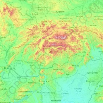
Name: Slovakia topographic map, elevation, terrain.
Location: Slovakia (47.73118 16.83319 49.61382 22.56571)
Average elevation: 313 m
Minimum elevation: 79 m
Maximum elevation: 2,451 m
Make a donation
Other topographic maps
Click on a map to view its topography, its elevation and its terrain.
Auckland
Auckland’s topography is uniquely shaped by its position on a narrow, undulating isthmus between the Waitematā Harbour to the north and the Manukau Harbour to the south, creating a landscape defined by low coastal plains interrupted by abrupt volcanic relief. The city stands atop the Auckland Volcanic…
Average elevation: 32 m
Wellington
New Zealand > Wellington > Wellington City
Averaging 2,055 hours of sunshine per year, the climate of Wellington is temperate marine, (Köppen: Cfb), generally moderate all year round with warm summers and mild winters, and rarely sees temperatures above 23 °C (73 °F) or below 4 °C (39 °F). The hottest recorded temperature in the city is 31.1 °C…
Average elevation: 85 m
Washington, D.C.
United States of America > Washington, D.C. > Washington, D.C.
The highest natural elevation in the District is 409 feet (125 m) above sea level at Fort Reno Park in upper northwest Washington. The lowest point is sea level at the Potomac River. The geographic center of Washington is near the intersection of 4th and L Streets NW.
Average elevation: 63 m
Make a donation
Dunedin
New Zealand > Otago > Dunedin City
The climate of Dunedin in general is temperate. The city is recognised as having a large number of microclimates and the weather conditions often vary between suburbs mostly due to the city's topographical layout. Under the Köppen climate classification, Dunedin features an oceanic climate. The city's climate…
Average elevation: 110 m
Tagaytay
Philippines > Cavite > Tagaytay > Tagaytay
The southern and eastern portions of Tagaytay are covered by hills and mountains which is generally forests, pine trees and open grasslands. The city lies along Tagaytay Ridge, a ridge stretching about 32 kilometres (20 mi) from Mount Batulao in the west to Mount Sungay in the east with elevations averaging…
Average elevation: 229 m
Queenstown
New Zealand > Otago > Queenstown-Lakes District
The town is at a relatively low altitude for a ski and snowboarding centre, at 310 metres (1,020 ft) above sea level at the lake shore, but is nestled among mountains, most notably the scenic attraction of The Remarkables, to the town's southeast. Below the lake lies the deep Kawarau Gorge, and there are…
Average elevation: 592 m
Make a donation
Baguio
Philippines > Benguet > Baguio
In 1903, Filipinos, Japanese and Chinese workers were hired to build Kennon Road, the first road directly connecting Baguio with the lowlands of La Union and Pangasinan. Before this, the only road to Benguet was Naguilian Road, and it was largely a horse trail at higher elevations. Camp John Hay was…
Average elevation: 882 m
Make a donation
Berlin
Berlin straddles the banks of the River Spree, which flows into the River Havel (a tributary of the River Elbe) in the western borough of Spandau. Among the city's main topographical features are the many lakes in the western and southeastern boroughs formed by the Spree, Havel, and Dahme rivers (the largest…
Average elevation: 47 m
Make a donation
Clark
The development is not a flood-prone area with its minimum elevation being at 54 metres (177 ft) above sea level and its planned central park also serves as a flood catchment basin. The Sierra Madre mountain range is located on the development's east while the Zambales mountain range is located on the west,…
Average elevation: 190 m
Antipolo
Its higher elevation than that of Metro Manila affords it a scenic view of the metropolis, especially at night. Its locally grown mangoes and cashews are popular among tourists, as well as suman – a local delicacy made out of glutinous rice. The Hinulugang Taktak National Park, which was once a popular…
Average elevation: 125 m
Auckland Domain
New Zealand > Auckland > Auckland
During the 2023 Auckland Anniversary Weekend floods, a lake reformed in the lower elevation area of Pukekawa / Auckland Domain that was once a wetland.
Average elevation: 49 m
Make a donation
Marshall Islands
The average altitude above sea level for the entire country is 7 feet (2.1 m).
Average elevation: 0 m
Make a donation
Make a donation
Make a donation
Mount Arthur
Mount Arthur (Tuao Wharepapa in Māori) is in the Wharepapa / Arthur Range in the north western area of the South Island of New Zealand. Mount Arthur, named after Captain Arthur Wakefield, lies within Kahurangi National Park and has a peak elevation of 1,795 metres (5,889 ft).
Average elevation: 1,447 m
Make a donation
Palmerston North
New Zealand > Manawatu-Whanganui > Palmerston North City
Although the land Palmerston North is situated on is bounded by the lofty Ruahine and Tararua ranges in the east and south respectively, the city has a predominantly flat appearance. The occasional rise in elevation occurs further away from the river and is especially pronounced in the north and northeast, and…
Average elevation: 118 m
Make a donation
Lake Quill
New Zealand > Southland > Southland District > Fiordland Community
Average elevation: 1,228 m
Make a donation
Dumaguete
Philippines > Negros Oriental > Dumaguete
As a coastal city, it is bounded on the east by the Bohol Sea and the Tañon Strait, serving as a natural border of southeastern Negros Island Region to the neighboring Central Visayas. The city's topography is generally flat from two to six kilometers from the shoreline. It slopes gently upwards to the…
Average elevation: 167 m
Make a donation
Santa Maria
The topography of Santa Maria is generally flat, however, it is becoming hilly towards the north. This area covers the barangays of Silangan, Mag-asawang Sapa, Pulong Buhangin and some parts of Balasing with landscape ranging from 8 to 18 percent slope. The rest of the barangays have a slope range from level…
Average elevation: 18 m
San Jose del Monte
The elevation of the city ranges from approximately 40 to 900 meters (130 to 2,950 ft) above sea level; the relief transitions from warm lowland to cool upland as one goes eastward. This is because the city is part of the Sierra Madre mountain range. Plains and river valley flats characterize the western and…
Average elevation: 106 m
Make a donation
Make a donation
Make a donation
Make a donation
Mararoa River
New Zealand > Southland > Southland District > Fiordland Community
Average elevation: 681 m
Catskill mountains view
United States > New York > Greene County > Town of Hunter
Average elevation: 740 m
Make a donation
Make a donation
Make a donation
Make a donation
Age Glacier
New Zealand > Southland > Southland District > Fiordland Community
Average elevation: 1,753 m
Make a donation
Tikitapu / Blue Lake
New Zealand > Bay of Plenty > Rotorua Lakes District > Rotorua
Average elevation: 520 m
Make a donation
Make a donation
Lake Pauri
New Zealand > Manawatu-Whanganui > Whanganui District > Whanganui > Pauri Village
Average elevation: 57 m
Kaitoke Lake
New Zealand > Manawatu-Whanganui > Whanganui District > Whanganui
Average elevation: 41 m
Make a donation
Lake Wiritoa
New Zealand > Manawatu-Whanganui > Whanganui District > Whanganui > Pauri Village
Average elevation: 50 m
Make a donation