
Make a donation
North Carolina topographic map
Click on the map to display elevation.
Make a donation
North Carolina
North Carolina features a diverse topography that can be divided into three distinct regions: the Coastal Plain, the Piedmont, and the Appalachian Mountains. The Coastal Plain, which occupies the eastern part of the state, is characterized by flat and gently sloping land, with elevations typically less than 300 feet (91 meters). This area includes vast wetlands and estuaries, along with barrier islands like the Outer Banks, known for their sandy beaches and unique ecosystems. Moving westward, the Piedmont region presents a more undulating landscape, with rolling hills and elevations ranging from 300 to about 1,500 feet (91 to 457 meters). This region is the state's urban and industrial center, home to major cities and fertile agricultural land. Finally, the Appalachian Mountains dominate the western part of the state, where peaks rise dramatically, with Mount Mitchell reaching over 6,600 feet (2,012 meters), making it the highest point in eastern North America. This mountainous terrain features deep valleys and lush forests, contributing to the region's rich biodiversity and scenic beauty.
Make a donation
About this map
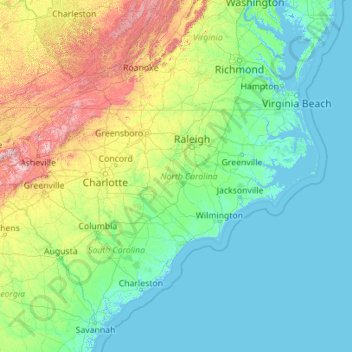
Name: North Carolina topographic map, elevation, terrain.
Location: North Carolina, United States (33.75288 -84.32183 36.58816 -75.40012)
Average elevation: 163 m
Minimum elevation: -3 m
Maximum elevation: 1,945 m
Make a donation
Other topographic maps
Click on a map to view its topography, its elevation and its terrain.
Houston
United States > Texas > Harris County > Houston
Houston is located 165 miles (266 km) east of Austin, 88 miles (142 km) west of the Louisiana border, and 250 miles (400 km) south of Dallas. The city has a total area of 637.4 square miles (1,651 km2); this comprises over 599.59 square miles (1,552.9 km2) of land and 22.3 square miles (58 km2) covered by…
Average elevation: 18 m
Salt Lake City
United States > Utah > Salt Lake County > Salt Lake City
Salt Lake City has an area of 110.4 square miles (286 km2) and an average elevation of 4,327 feet (1,319 m) above sea level. The lowest point within the boundaries of the city is 4,210 feet (1,280 m) near the Jordan River and the Great Salt Lake, and the highest is Grandview Peak, at 9,410 feet (2,868 m).
Average elevation: 1,625 m
Boston
United States > Massachusetts > Suffolk County > Boston
Boston has an area of 89.63 square miles (232.1 km2)—48.4 square miles (125.4 km2) (54%) of land and 41.2 square miles (106.7 km2) (46%) of water. The city's official elevation, as measured at Logan International Airport, is 19 ft (5.8 m) above sea level. The highest point in Boston is Bellevue Hill at 330…
Average elevation: 26 m
Make a donation
Little Saint James Island
United States > United States Virgin Islands > Saint Thomas - Saint John District
Average elevation: 1 m
Make a donation
Oakhurst
United States > California > Madera County
Oakhurst (formerly Fresno Flats) is a census-designated place (CDP) in Madera County, California, United States, 14 miles (23 km) south of the entrance to Yosemite National Park, in the foothills of the Sierra Nevada. At an elevation of 2,274 ft (693 m), Oakhurst is situated at the junction of Highway 41 and…
Average elevation: 837 m
Make a donation
Glacier
United States > Washington > Whatcom County
Glacier is a census-designated place in the North Fork Nooksack River Valley, at an elevation of 906 ft., just 10 miles northwest of the Mount Baker Summit towering nearly 10,000 ft above it, in Whatcom County, Washington, United States. The population was 300 at the 2020 census.
Average elevation: 435 m
Make a donation
Make a donation
Make a donation
Make a donation
Monument Valley Park
United States > Colorado > El Paso County > Colorado Springs
Average elevation: 1,857 m
Make a donation
San Francisco Bay Area
United States > California > San Francisco
The borders of the San Francisco Bay Area are not officially delineated, and the unique development patterns influenced by the region's topography, as well as unusual commute patterns caused by the presence of three central cities and employment centers located in various suburban locales, has led to…
Average elevation: 113 m
Make a donation
Cougar Creek Park
United States > Nevada > Clark County > Las Vegas > Enterprise
Average elevation: 771 m
Make a donation
Rancho Peñasquitos
United States > California > San Diego County > San Diego
The highest point in the community is Black Mountain, which rises to an elevation of 1,500 feet (460 m).
Average elevation: 157 m
Make a donation
Minnehaha Regional Park
United States > Minnesota > Hennepin County > Minneapolis
Fortunately for the generations to come, in 1883 the state legislature created the Minneapolis Board of Park Commissioners. The board began by acquiring park land near today's downtown Minneapolis. Their choice to hire noted landscape architect Horace Cleveland was fortunate. Cleveland was hired by the Board…
Average elevation: 249 m
Make a donation
Make a donation
Meridian Hill/Malcolm X Park
United States > District of Columbia > Washington
Average elevation: 44 m
Make a donation
Make a donation
Make a donation
Make a donation
Seymour
United States > Texas > Baylor County
The climate is humid subtropical (Köppen: Cfa) with an extreme temperature deviation, but much of the time, the variation is always more and the warm weather prevails over the cold as the averages and the records show. Its subtropical location and south of the center of a large land mass bring occasional…
Average elevation: 401 m
Heaton
United States > Arizona > Pinal County > Maricopa
Heaton is a populated place situated in Pinal County, Arizona, United States. It has an estimated elevation of 1,197 feet (365 m) above sea level.
Average elevation: 367 m
Make a donation
Make a donation
Elkins Park Gardens
United States > Pennsylvania > Montgomery County > Cheltenham Township > Cheltenham
Average elevation: 70 m
Make a donation
Bala Cynwyd
United States > Pennsylvania > Montgomery County > Lower Merion Township
Average elevation: 75 m
Make a donation
Make a donation
Feasterville
United States > Pennsylvania > Bucks County > Lower Southampton Township
Average elevation: 66 m
Winnipauk
United States > Connecticut > Western Connecticut Planning Region > Norwalk
Average elevation: 51 m
Make a donation
Spring Island
United States > Maine > Penobscot County > T4 Indian Purchase Township
Average elevation: 151 m
Make a donation
Make a donation