
Make a donation
Vietnam topographic map
Click on the map to display elevation.
Make a donation
Vietnam
Due to differences in latitude and the marked variety in topographical relief, Vietnam's climate tends to vary considerably for each region. Vietnam is a country located in the tropics, however Northern Vietnam, including Hanoi, is considered a subtropical region by Köppen climate classification and has times to be influenced by cold waves from the Northeast. Cold waves also can influence northern part of Central Vietnam. During the winter or dry season, extending roughly from November to April, the monsoon winds usually blow from the northeast along the Chinese coast and across the Gulf of Tonkin, picking up considerable moisture. The average annual temperature is generally higher in the plains than in the mountains, especially in southern Vietnam compared to the north. Temperatures vary less in the southern plains around Ho Chi Minh City and the Mekong Delta, ranging from between 21 and 35 °C (69.8 and 95.0 °F) over the year. In Hanoi and the surrounding areas of Red River Delta, the temperatures are much lower between 15 and 33 °C (59.0 and 91.4 °F). Seasonal variations in the mountains, plateaus, and the northernmost areas are much more dramatic, with temperatures varying from 3 °C (37.4 °F) in December and January to 37 °C (98.6 °F) in July and August. During winter, snow occasionally falls over the highest peaks of the far northern mountains near the Chinese border. Vietnam receives high rates of precipitation in the form of rainfall with an average amount from 1,500 mm (59 in) to 2,000 mm (79 in) during the monsoon seasons; this often causes flooding, especially in the cities with poor drainage systems. The country is also affected by tropical depressions, tropical storms and typhoons. Vietnam is one of the most vulnerable countries to climate change, with 55% of its population living in low-elevation coastal areas.
Make a donation
About this map
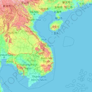
Name: Vietnam topographic map, elevation, terrain.
Location: Vietnam (7.69209 102.14386 23.39269 114.85726)
Average elevation: 173 m
Minimum elevation: -3 m
Maximum elevation: 2,808 m
Make a donation
Other topographic maps
Click on a map to view its topography, its elevation and its terrain.
Auckland
Auckland’s topography is uniquely shaped by its position on a narrow, undulating isthmus between the Waitematā Harbour to the north and the Manukau Harbour to the south, creating a landscape defined by low coastal plains interrupted by abrupt volcanic relief. The city stands atop the Auckland Volcanic…
Average elevation: 32 m
Washington, D.C.
United States of America > Washington, D.C. > Washington, D.C.
The highest natural elevation in the District is 409 feet (125 m) above sea level at Fort Reno Park in upper northwest Washington. The lowest point is sea level at the Potomac River. The geographic center of Washington is near the intersection of 4th and L Streets NW.
Average elevation: 63 m
Wellington
New Zealand > Wellington > Wellington City
Averaging 2,055 hours of sunshine per year, the climate of Wellington is temperate marine, (Köppen: Cfb), generally moderate all year round with warm summers and mild winters, and rarely sees temperatures above 23 °C (73 °F) or below 4 °C (39 °F). The hottest recorded temperature in the city is 31.1 °C…
Average elevation: 85 m
Baguio
Philippines > Benguet > Baguio
In 1903, Filipinos, Japanese and Chinese workers were hired to build Kennon Road, the first road directly connecting Baguio with the lowlands of La Union and Pangasinan. Before this, the only road to Benguet was Naguilian Road, and it was largely a horse trail at higher elevations. Camp John Hay was…
Average elevation: 882 m
Make a donation
Dunedin
New Zealand > Otago > Dunedin City
The climate of Dunedin in general is temperate. The city is recognised as having a large number of microclimates and the weather conditions often vary between suburbs mostly due to the city's topographical layout. Under the Köppen climate classification, Dunedin features an oceanic climate. The city's climate…
Average elevation: 110 m
Clark
The development is not a flood-prone area with its minimum elevation being at 54 metres (177 ft) above sea level and its planned central park also serves as a flood catchment basin. The Sierra Madre mountain range is located on the development's east while the Zambales mountain range is located on the west,…
Average elevation: 190 m
Make a donation
Make a donation
Houston
United States > Texas > Harris County > Houston
Houston is located 165 miles (266 km) east of Austin, 88 miles (142 km) west of the Louisiana border, and 250 miles (400 km) south of Dallas. The city has a total area of 637.4 square miles (1,651 km2); this comprises over 599.59 square miles (1,552.9 km2) of land and 22.3 square miles (58 km2) covered by…
Average elevation: 18 m
San Juan
"San Juan" is a contraction of the city's traditional name of "San Juan del Monte" (lit. 'Saint John of the Mountain'). As with numerous other places in the Philippines, the name combines a patron saint and a toponym; in this case Saint John the Baptist with the locale's hilly terrain and relatively higher…
Average elevation: 35 m
Make a donation
Make a donation
Antipolo
Its higher elevation than that of Metro Manila affords it a scenic view of the metropolis, especially at night. Its locally grown mangoes and cashews are popular among tourists, as well as suman – a local delicacy made out of glutinous rice. The Hinulugang Taktak National Park, which was once a popular…
Average elevation: 125 m
Queenstown
New Zealand > Otago > Queenstown-Lakes District
The town is at a relatively low altitude for a ski and snowboarding centre, at 310 metres (1,020 ft) above sea level at the lake shore, but is nestled among mountains, most notably the scenic attraction of The Remarkables, to the town's southeast. Below the lake lies the deep Kawarau Gorge, and there are…
Average elevation: 592 m
Make a donation
Make a donation
Make a donation
Mount Arthur
Mount Arthur (Tuao Wharepapa in Māori) is in the Wharepapa / Arthur Range in the north western area of the South Island of New Zealand. Mount Arthur, named after Captain Arthur Wakefield, lies within Kahurangi National Park and has a peak elevation of 1,795 metres (5,889 ft).
Average elevation: 1,447 m
Make a donation
Africa
Average elevation: 462 m
Bathgate
United Kingdom > Scotland > West Lothian
In the 1846 book A Topographical Dictionary of Scotland, Samuel Lewis writes.
Average elevation: 167 m
Port hills
New Zealand > Canterbury > Christchurch City > Linwood-Central-Heathcote Community
Average elevation: 246 m
Make a donation
Make a donation
Make a donation
Marshall Islands
The average altitude above sea level for the entire country is 7 feet (2.1 m).
Average elevation: 0 m
Make a donation
Berlin
Berlin straddles the banks of the River Spree, which flows into the River Havel (a tributary of the River Elbe) in the western borough of Spandau. Among the city's main topographical features are the many lakes in the western and southeastern boroughs formed by the Spree, Havel, and Dahme rivers (the largest…
Average elevation: 47 m
Make a donation
Palmerston North
New Zealand > Manawatu-Whanganui > Palmerston North City
Although the land Palmerston North is situated on is bounded by the lofty Ruahine and Tararua ranges in the east and south respectively, the city has a predominantly flat appearance. The occasional rise in elevation occurs further away from the river and is especially pronounced in the north and northeast, and…
Average elevation: 118 m
Make a donation
Make a donation
Santa Maria
The topography of Santa Maria is generally flat, however, it is becoming hilly towards the north. This area covers the barangays of Silangan, Mag-asawang Sapa, Pulong Buhangin and some parts of Balasing with landscape ranging from 8 to 18 percent slope. The rest of the barangays have a slope range from level…
Average elevation: 18 m
Make a donation
Make a donation
Make a donation
Make a donation
Make a donation
Make a donation
Make a donation
Make a donation
Make a donation