
São Tomé and Príncipe topographic map
Interactive map
Click on the map to display elevation.
About this map
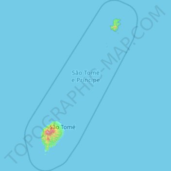
Name: São Tomé and Príncipe topographic map, elevation, terrain.
Location: São Tomé and Príncipe (-0.21351 6.26064 1.92576 7.67048)
Average elevation: 6 m
Minimum elevation: 0 m
Maximum elevation: 1,967 m
At sea level, the climate is tropical—hot and humid with average yearly temperatures of about 26 °C (78.8 °F) and little daily variation. The temperature rarely rises beyond 32 °C (89.6 °F). At the interior's higher elevations, the average yearly temperature is 20 °C (68 °F), and nights are generally cool. Annual rainfall varies from 7,000 mm (275.6 in) in the highland cloud forests to 800 mm (31.5 in) in the northern lowlands. The rainy season is from October to May.
Other topographic maps
Click on a map to view its topography, its elevation and its terrain.
Philippines
Philippines
Average elevation: 33 m
Auckland
Auckland, Waitematā, Auckland, 1010, New Zealand
Average elevation: 32 m
Davao City
Philippines > Davao Occidental > Davao City
Davao City, Davao Occidental, Davao Region, Philippines
Average elevation: 303 m
Las Vegas
United States > Nevada > Clark County
Las Vegas, Clark County, Nevada, United States
Average elevation: 756 m
Wellington
New Zealand > Wellington > Wellington City
Wellington, Wellington City, Wellington, 6011, New Zealand
Average elevation: 85 m
Parañaque
Philippines > Parañaque > Parañaque
Parañaque, Southern Manila District, Metro Manila, Philippines
Average elevation: 11 m
Christchurch City
Christchurch City, Canterbury, New Zealand
Average elevation: 74 m
Calamba
Philippines > Laguna > Calamba > Calamba
Calamba, Laguna, Calabarzon, 4027, Philippines
Average elevation: 100 m
Dunedin
New Zealand > Otago > Dunedin City
Dunedin, Dunedin City, Otago, 9054, New Zealand
Average elevation: 110 m
Pachacámac
Pachacámac, Lurín, Province of Lima, Lima, Peru
Average elevation: 327 m
Queenstown
New Zealand > Otago > Queenstown-Lakes District
Queenstown, Queenstown-Lakes District, Otago, 9348, New Zealand
Average elevation: 592 m
Tagaytay
Philippines > Cavite > Tagaytay > Tagaytay
Tagaytay, Cavite, Calabarzon, 4120, Philippines
Average elevation: 229 m
San Jose del Monte
San Jose del Monte, Bulacan, Central Luzon, 3023, Philippines
Average elevation: 106 m
Brisbane
Australia > Queensland > Brisbane
Brisbane, Queensland, 4000, Australia
Average elevation: 45 m
York County
York County, Pennsylvania, United States
Average elevation: 170 m
Hamilton
New Zealand > Waikato > Hamilton City > Hamilton
Hamilton, Hamilton City, Waikato, 03204, New Zealand
Average elevation: 53 m
Christchurch
New Zealand > Canterbury > Christchurch City
Christchurch, Christchurch City, Canterbury, New Zealand
Average elevation: 41 m
New Zealand
New Zealand
Average elevation: 399 m
Havila
Philippines > Rizal > Taytay
Havila, Taytay, Rizal, Calabarzon, 1880, Philippines
Average elevation: 106 m
Los Gatos
United States > California > Santa Clara County
Los Gatos, Santa Clara County, California, 95030, United States
Average elevation: 209 m
Los Altos
Los Altos, Burgos, Castile and León, 09551, Spain
Average elevation: 920 m
Siripura
Sri Lanka > North Central Province
Siripura, Polonnaruwa District, North Central Province, Sri Lanka
Average elevation: 70 m
Narammala
Sri Lanka > North Western Province
Narammala, Kurunegala District, North Western Province, 60100, Sri Lanka
Average elevation: 81 m
Girandurukotte
Girandurukotte, Badulla District, Uva Province, Sri Lanka
Average elevation: 96 m
Dambadeniya
Sri Lanka > North Western Province
Dambadeniya, Kurunegala District, North Western Province, 60130, Sri Lanka
Average elevation: 64 m
Sandunpura
Sandunpura, Ampara District, Eastern Province, Sri Lanka
Average elevation: 89 m
Ocheretyne
Ocheretyne, Ocheretyne settlement hromada, Pokrovskii Raion, Donetsk Oblast, 86020, Ukraine
Average elevation: 227 m
Baguio
Philippines > Benguet > Baguio
Baguio, Benguet, Cordillera Administrative Region, 2600, Philippines
Average elevation: 882 m
Chino
United States > California > San Bernardino County
Chino, San Bernardino County, California, United States
Average elevation: 239 m
Jerusalem
Israel > Jerusalem District > Jerusalem
Jerusalem, Jerusalem District, Israel
Average elevation: 661 m
Mawathagama
Sri Lanka > North Western Province
Mawathagama, Kurunegala District, North Western Province, Sri Lanka
Average elevation: 199 m
Napier
Napier, Napier City, Hawke's Bay, 4001, New Zealand
Average elevation: 33 m
Pindimar
Pindimar, Mid-Coast Council, New South Wales, 2324, Australia
Average elevation: 18 m
Tamlangon
Philippines > Davao del Sur > Matanao
Tamlangon, Matanao, Davao del Sur, Davao Region, 8003, Philippines
Average elevation: 61 m
Montecristo
Montecristo, Mojana, Bolívar, RAP Caribe, Colombia
Average elevation: 457 m
New Brunswick
United States > New Jersey > Middlesex County
New Brunswick, Middlesex County, New Jersey, United States
Average elevation: 25 m
Whangārei
New Zealand > Northland > Whangarei District
Whangārei, Whangarei District, Northland, 0110, New Zealand
Average elevation: 96 m
New Norfolk
New Norfolk, Derwent Valley, Tasmania, 7140, Australia
Average elevation: 120 m
Ruru
New Zealand > Moana > Ruru
Ruru, Moana, Grey District, West Coast, 7845, New Zealand
Average elevation: 124 m
The Villages
United States > Florida > Sumter County
The Villages, Sumter County, Florida, United States
Average elevation: 25 m
Oxford
United Kingdom > England > Oxfordshire
Oxford, Oxfordshire, England, United Kingdom
Average elevation: 81 m
Gisborne
New Zealand > Gisborne > Gisborne District
Gisborne, Gisborne District, Gisborne, 4010, New Zealand
Average elevation: 70 m