
Make a donation
Far North District topographic map
Click on the map to display elevation.
Make a donation
About this map
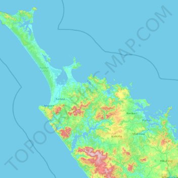
Name: Far North District topographic map, elevation, terrain.
Location: Far North District, Northland, New Zealand (-35.67592 172.63479 -34.39339 174.34163)
Average elevation: 47 m
Minimum elevation: 0 m
Maximum elevation: 748 m
Northland trails, hiking, mountain biking, running and outdoor activities
Make a donation
Other topographic maps
Click on a map to view its topography, its elevation and its terrain.
Waihou Valley
New Zealand > Northland > Far North District > Kaikohe-Hokianga Community
Average elevation: 86 m
Pungaere Stream
New Zealand > Northland > Far North District > Bay of Islands-Whangaroa Community
Average elevation: 183 m
Pukawa
New Zealand > Northland > Far North District > Kaikohe-Hokianga Community
Average elevation: 101 m
Make a donation
Broadwood
New Zealand > Northland > Far North District > Kaikohe-Hokianga Community
Average elevation: 144 m
Whirinaki
New Zealand > Northland > Far North District > Kaikohe-Hokianga Community
Average elevation: 71 m
Make a donation
Fern Hill
New Zealand > Northland > Far North District > Kaikohe-Hokianga Community
Average elevation: 122 m
Rangitoto
New Zealand > Northland > Far North District > Kaikohe-Hokianga Community
Average elevation: 24 m
Make a donation
Pakaraka
New Zealand > Northland > Far North District > Bay of Islands-Whangaroa Community
Average elevation: 92 m
Uruti Bay
New Zealand > Northland > Far North District > Bay of Islands-Whangaroa Community
Average elevation: 21 m
Make a donation
Taumarere
New Zealand > Northland > Far North District > Bay of Islands-Whangaroa Community > Kawakawa
Average elevation: 53 m
Matangirau
New Zealand > Northland > Far North District > Bay of Islands-Whangaroa Community
Average elevation: 16 m
Puponga Point
New Zealand > Northland > Far North District > Te Hiku Community
Average elevation: 13 m
Make a donation
Make a donation
Make a donation
Make a donation
Rotokakahi
New Zealand > Northland > Far North District > Kaikohe-Hokianga Community
Average elevation: 90 m
Kaeo River
New Zealand > Northland > Far North District > Bay of Islands-Whangaroa Community
Average elevation: 121 m
Make a donation
Kaikohe
New Zealand > Northland > Far North District > Kaikohe-Hokianga Community
Average elevation: 218 m
Rawhiti
New Zealand > Northland > Far North District > Bay of Islands-Whangaroa Community
Average elevation: 45 m
Utakura River
New Zealand > Northland > Far North District > Kaikohe-Hokianga Community
Average elevation: 124 m
Make a donation
Waitangi
New Zealand > Northland > Far North District > Bay of Islands-Whangaroa Community
Average elevation: 15 m
Waiparera Stream
New Zealand > Northland > Far North District > Te Hiku Community
Average elevation: 5 m
Runaruna
New Zealand > Northland > Far North District > Kaikohe-Hokianga Community
Average elevation: 81 m
Make a donation
Haruru Falls
New Zealand > Northland > Far North District > Bay of Islands-Whangaroa Community > Haruru
Average elevation: 34 m
Make a donation
Kaeo
New Zealand > Northland > Far North District > Bay of Islands-Whangaroa Community
Average elevation: 75 m
Make a donation
Onewhero Bay
New Zealand > Northland > Far North District > Bay of Islands-Whangaroa Community
Average elevation: 18 m
Ruatangata West
New Zealand > Northland > Whangarei District > Ruatangata West
Average elevation: 152 m
Coopers Beach
New Zealand > Northland > Far North District > Te Hiku Community
Average elevation: 42 m
Make a donation
Tauwhare
New Zealand > Northland > Far North District > Kaikohe-Hokianga Community
Average elevation: 281 m
Make a donation