
Central Otago District topographic map
Interactive map
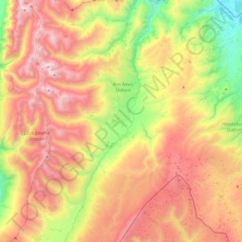
Click on the map to display elevation.
Central Otago District topographic map, elevation, terrain
About this map
Name: Central Otago District topographic map, elevation, terrain.
Location: Central Otago District, Otago, New Zealand, Nevis River (-45.34925 168.87435 -45.06042 169.03694)
Average elevation: 1,201 m
Minimum elevation: 195 m
Maximum elevation: 2,280 m
Other topographic maps
Click on a map to view its topography, its elevation and its terrain.
Queenstown
New Zealand > Otago > Queenstown-Lakes District
The town is at a relatively low altitude for a ski and snowboarding centre, at 310 metres (1,020 ft) above sea level at the lake shore, but is nestled among mountains, most notably the scenic attraction of The Remarkables, to the town's southeast. Below the lake lies the deep Kawarau Gorge, and there are…
Average elevation: 592 m
Dunedin
New Zealand > Otago > Dunedin City
The climate of Dunedin in general is temperate. The city is recognised as having a large number of microclimates and the weather conditions often vary between suburbs mostly due to the city's topographical layout. Under the Köppen climate classification, Dunedin features an oceanic climate. The city's climate…
Average elevation: 110 m
Cromwell
New Zealand > Otago > Central Otago District > Cromwell Community > Cromwell
Average elevation: 330 m
Clyde Dam
New Zealand > Otago > Central Otago District > Vincent Community > Clyde
Average elevation: 318 m
Kelvin Peninsula
New Zealand > Otago > Queenstown-Lakes District > Queenstown
Average elevation: 372 m
Blue Lake
New Zealand > Otago > Central Otago District > Vincent Community > Saint Bathans
Average elevation: 605 m
Ranfurly
New Zealand > Otago > Central Otago District
Ranfurly is a town in the Central Otago District of Otago, New Zealand. Located 110 kilometres (68 miles) north of Dunedin, it lies in the dry rough plain of Maniototo at a moderately high altitude (around 430 metres or 1,410 feet above sea level) close to a small tributary of the Taieri River. It operates as…
Average elevation: 429 m
Signal Hill
New Zealand > Otago > Dunedin City > Dunedin
Signal Hill (Maori: Te Pahuri o te Rangipohika) is a prominent landform in the city of Dunedin, New Zealand. It is located close to, and due north of, the head of the Otago Harbour and reaches an elevation of 393 m (1289 ft). The suburbs Ravensbourne, St. Leonards, and Opoho lie on its southern, eastern, and…
Average elevation: 174 m
Central Otago
New Zealand > Otago > Central Otago District > Vincent Community
Average elevation: 935 m
Lake Wakatipu
New Zealand > Otago > Queenstown-Lakes District
With a length of 80 kilometres (50 mi), it is New Zealand's longest lake, and, at 289 km2 (112 sq mi), its third largest. The lake is also very deep, its floor being below sea level (−110 metres), with a maximum depth of 420 metres (1,380 ft). It is at an altitude of 310 metres (1,020 ft), towards the…
Average elevation: 952 m
Shingle Creek
New Zealand > Otago > Central Otago District > Teviot Valley Community
Average elevation: 307 m
Roxburgh
New Zealand > Otago > Central Otago District > Teviot Valley Community
Average elevation: 223 m