
Fiordland National Park topographic map
Interactive map
Click on the map to display elevation.
About this map
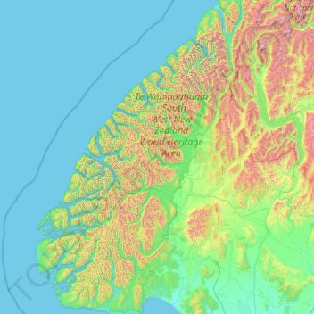
Name: Fiordland National Park topographic map, elevation, terrain.
Location: Fiordland National Park, New Zealand (-46.25124 166.42555 -44.33187 168.23983)
Average elevation: 417 m
Minimum elevation: 0 m
Maximum elevation: 2,819 m
Several large lakes lie wholly or partly within the park's boundaries, notably Lake Te Anau and Lake Manapouri, both on the western boundary of the national park, as well as the southern lakes Lake Monowai, Lake Hauroko, and Lake Poteriteri. All of these lakes exhibit the topography typical of glacier-carved valleys, with Lake Te Anau and Lake Manapouri in particular having several arms similar in look to the fiords on the west coast of the park.
Other topographic maps
Click on a map to view its topography, its elevation and its terrain.
Auckland
Auckland, Waitematā, Auckland, 1010, New Zealand
Average elevation: 32 m
Dunedin
New Zealand > Otago > Dunedin City
Dunedin, Dunedin City, Otago, 9054, New Zealand
Average elevation: 110 m
Wellington
New Zealand > Wellington > Wellington City
Wellington, Wellington City, Wellington, 6011, New Zealand
Average elevation: 85 m
Lower Hutt
New Zealand > Wellington > Lower Hutt City
Lower Hutt, Lower Hutt City, Wellington, 5040, New Zealand
Average elevation: 173 m
Queenstown
New Zealand > Otago > Queenstown-Lakes District
Queenstown, Queenstown-Lakes District, Otago, 9348, New Zealand
Average elevation: 592 m
Auckland Domain
New Zealand > Auckland > Auckland
Auckland Domain, Parnell, Auckland, Waitematā, Auckland, New Zealand
Average elevation: 49 m
Whangārei
New Zealand > Northland > Whangarei District
Whangārei, Whangarei District, Northland, 0110, New Zealand
Average elevation: 96 m
Tauranga
New Zealand > Bay of Plenty > Tauranga City
Tauranga, Tauranga City, Bay of Plenty, 3110, New Zealand
Average elevation: 66 m
Christchurch
New Zealand > Canterbury > Christchurch City
Christchurch, Christchurch City, Canterbury, New Zealand
Average elevation: 41 m
Christchurch City
Christchurch City, Canterbury, New Zealand
Average elevation: 74 m
Invercargill
New Zealand > Southland > Invercargill City > Invercargill
Invercargill, Invercargill City, Southland, 9810, New Zealand
Average elevation: 16 m
Duvauchelle
New Zealand > Canterbury > Christchurch City > Banks Peninsula Community
Duvauchelle, Banks Peninsula Community, Christchurch City, Canterbury, 7581, New Zealand
Average elevation: 277 m
Napier
Napier, Napier City, Hawke's Bay, 4001, New Zealand
Average elevation: 33 m
Whanganui
New Zealand > Manawatu-Whanganui > Whanganui District
Whanganui, Whanganui District, Manawatū-Whanganui, 4500, New Zealand
Average elevation: 74 m
Gisborne
New Zealand > Gisborne > Gisborne District
Gisborne, Gisborne District, Gisborne, 4010, New Zealand
Average elevation: 70 m
Palmerston North
New Zealand > Palmerston North
Palmerston North, Palmerston North City, Manawatu-Wanganui, 4440, New Zealand
Average elevation: 118 m
New Plymouth
New Zealand > Taranaki > New Plymouth District
New Plymouth, New Plymouth District, Taranaki, 4310, New Zealand
Average elevation: 92 m
Lake Rotoiti
New Zealand > Tasman > Saint Arnaud
Lake Rotoiti, Saint Arnaud, Tasman, New Zealand
Average elevation: 1,031 m
Windwhistle
New Zealand > Canterbury > Selwyn District
Windwhistle, Selwyn District, Canterbury, New Zealand
Average elevation: 434 m
Point England
New Zealand > Auckland > Maungakiekie-Tamaki
Point England, Maungakiekie-Tāmaki, Auckland, 1072, New Zealand
Average elevation: 11 m
Hanmer Springs
New Zealand > Canterbury > Hurunui District
Hanmer Springs, Hurunui District, Canterbury, 7334, New Zealand
Average elevation: 397 m
Porirua
New Zealand > Wellington > Porirua City
Porirua, Porirua City, Wellington, 5022, New Zealand
Average elevation: 115 m
Taupō
New Zealand > Waikato > Taupo District
Taupō, Taupō District, Waikato, 3377, New Zealand
Average elevation: 423 m
Ruru
New Zealand > Moana > Ruru
Ruru, Moana, Grey District, West Coast, 7845, New Zealand
Average elevation: 124 m
Waiheke Island
New Zealand > Auckland > Waiheke
Waiheke Island, Waiheke, Auckland, New Zealand
Average elevation: 16 m
Wānaka
New Zealand > Otago > Queenstown-Lakes District
Wānaka, Queenstown-Lakes District, Otago, 9305, New Zealand
Average elevation: 381 m
Hamilton
New Zealand > Waikato > Hamilton City > Hamilton
Hamilton, Hamilton City, Waikato, 03204, New Zealand
Average elevation: 53 m
Timaru
New Zealand > Canterbury > Timaru District
Timaru, Timaru District, Canterbury, 7910, New Zealand
Average elevation: 16 m
Upper Hutt
New Zealand > Wellington > Upper Hutt City
Upper Hutt, Upper Hutt City, Wellington, 5218, New Zealand
Average elevation: 271 m
Mount Eden
New Zealand > Auckland > Albert-Eden
Mount Eden, Albert-Eden, Auckland, 1024, New Zealand
Average elevation: 81 m
Kāpiti Coast District
Kāpiti Coast District, Wellington, New Zealand
Average elevation: 355 m
Rotorua
New Zealand > Bay of Plenty > Rotorua Lakes District
Rotorua, Rotorua Lakes District, Bay of Plenty, 3010, New Zealand
Average elevation: 435 m
Waioneke
New Zealand > Auckland > Rodney
Waioneke, Rodney, Auckland, New Zealand
Average elevation: 27 m
Lake Rotoiti / Te Roto kite ā Ihenga i ariki ai Kahu
New Zealand > Bay of Plenty > Rotorua Lakes District > Okere Falls
Lake Rotoiti / Te Roto kite ā Ihenga i ariki ai Kahu, Okere Falls, Rotorua Lakes District, Bay of Plenty, New Zealand
Average elevation: 375 m
Eltham
New Zealand > Taranaki > South Taranaki District
Eltham, South Taranaki District, Taranaki, 4322, New Zealand
Average elevation: 223 m
Port hills
New Zealand > Canterbury > Christchurch City > Linwood-Central-Heathcote Community
Port hills, Greenwood Park Mountain Bike Track, Linwood-Central-Heathcote Community, Christchurch City, Canterbury, 8082, New Zealand
Average elevation: 246 m
North Shore
New Zealand > Auckland > Kaipātiki
North Shore, Tōtara Vale, Kaipātiki, Auckland, 0629, New Zealand
Average elevation: 57 m
Kairangi Hill
New Zealand > Waikato > Waipa District
Kairangi Hill, Waipa District, Waikato, New Zealand
Average elevation: 156 m
Koriniti Pā / Ōtūkōpiri
New Zealand > Manawatu-Whanganui > Whanganui District
Koriniti Pā / Ōtūkōpiri, Whanganui District, Manawatū-Whanganui, New Zealand
Average elevation: 208 m
Lawrence
New Zealand > Otago > Clutha District
Lawrence, Clutha District, Otago, 9532, New Zealand
Average elevation: 163 m
Rangiora
New Zealand > Canterbury > Waimakariri District
Rangiora, Waimakariri District, Canterbury, 7400, New Zealand
Average elevation: 31 m