
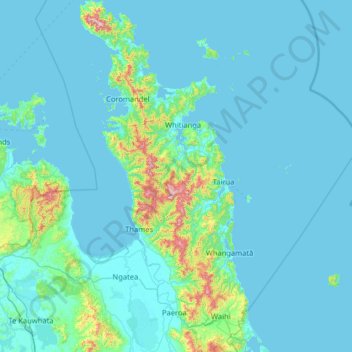
Te Tara-o-Te-Ika / Coromandel Peninsula topographic map
Interactive map
Click on the map to display elevation.
About this map
Name: Te Tara-o-Te-Ika / Coromandel Peninsula topographic map, elevation, terrain.
Average elevation: 56 m
Minimum elevation: -2 m
Maximum elevation: 851 m
Waikato trails, hiking, mountain biking, running and outdoor activities
Other topographic maps
Click on a map to view its topography, its elevation and its terrain.
Matarangi Bluff
New Zealand > Waikato > Thames-Coromandel District > Rings Beach
Average elevation: 21 m
Rangiaowhia War Memorial Domain
New Zealand > Waikato > Waipa District > Kihikihi > Rangiaowhia
Average elevation: 69 m