Geolocate

Canada topographic map

Click on the map to display elevation.

About this map

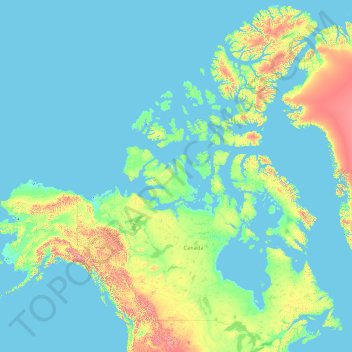
Name: Canada topographic map, elevation, terrain.

Location: Canada (41.67656 -141.00275 83.33621 -52.32377)

Average elevation: 254 m

Minimum elevation: -2 m

Maximum elevation: 4,944 m

Other topographic maps

Click on a map to view its topography, its elevation and its terrain.

Auckland

New Zealand > Auckland

Auckland’s topography is uniquely shaped by its position on a narrow, undulating isthmus between the Waitematā Harbour to the north and the Manukau Harbour to the south, creating a landscape defined by low coastal plains interrupted by abrupt volcanic relief. The city stands atop the Auckland Volcanic…

Average elevation: 32 m

Wellington

New Zealand > Wellington > Wellington City

Averaging 2,055 hours of sunshine per year, the climate of Wellington is temperate marine, (Köppen: Cfb), generally moderate all year round with warm summers and mild winters, and rarely sees temperatures above 23 °C (73 °F) or below 4 °C (39 °F). The hottest recorded temperature in the city is 31.1 °C…

Average elevation: 85 m

Atok

Philippines > Benguet

Average elevation: 1,814 m

Baguio

Philippines > Benguet > Baguio

In 1903, Filipinos, Japanese and Chinese workers were hired to build Kennon Road, the first road directly connecting Baguio with the lowlands of La Union and Pangasinan. Before this, the only road to Benguet was Naguilian Road, and it was largely a horse trail at higher elevations. Camp John Hay was…

Average elevation: 882 m

Tagaytay

Philippines > Cavite > Tagaytay > Tagaytay

The southern and eastern portions of Tagaytay are covered by hills and mountains which is generally forests, pine trees and open grasslands. The city lies along Tagaytay Ridge, a ridge stretching about 32 kilometres (20 mi) from Mount Batulao in the west to Mount Sungay in the east with elevations averaging…

Average elevation: 229 m

Earth

United States > Texas > Lamb County > Earth > Earth

Average elevation: 1,129 m

Pachacámac

Peru > Lima > Lurín

Average elevation: 327 m

Hamilton

New Zealand > Waikato > Hamilton City > Hamilton

Average elevation: 53 m

Blake

New Zealand > Wellington

Average elevation: 568 m

Nelson

New Zealand > Nelson

Average elevation: 207 m

Dunedin

New Zealand > Otago > Dunedin City

The climate of Dunedin in general is temperate. The city is recognised as having a large number of microclimates and the weather conditions often vary between suburbs mostly due to the city's topographical layout. Under the Köppen climate classification, Dunedin features an oceanic climate. The city's climate…

Average elevation: 110 m

Mackinnon Pass

New Zealand

Average elevation: 843 m

Tararua Range

New Zealand > Manawatu-Whanganui

Average elevation: 246 m

Amberley

New Zealand > Canterbury > Hurunui District

Average elevation: 55 m

Hope Range

New Zealand

Average elevation: 943 m

Haupiri Range

New Zealand

Average elevation: 996 m

Tasman Mountains

New Zealand

Average elevation: 842 m

Burnett Range

New Zealand

Average elevation: 168 m

Travers Range

New Zealand

Average elevation: 1,159 m

Wakamarama Range

New Zealand

Average elevation: 444 m

Lookout Range

New Zealand

Average elevation: 1,194 m

Mount Crosscut

New Zealand

Average elevation: 1,276 m

Mount Arthur

New Zealand

Mount Arthur (Tuao Wharepapa in Māori) is in the Wharepapa / Arthur Range in the north western area of the South Island of New Zealand. Mount Arthur, named after Captain Arthur Wakefield, lies within Kahurangi National Park and has a peak elevation of 1,795 metres (5,889 ft).

Average elevation: 1,447 m

Mount Travers

New Zealand

Average elevation: 1,658 m

Saint Arnaud

New Zealand

Average elevation: 713 m

Lake Rotoroa

New Zealand

Average elevation: 747 m

Wainui Falls

New Zealand

Average elevation: 279 m

Fairdown

New Zealand

Average elevation: 14 m

Wendon Valley

New Zealand

Average elevation: 200 m

Waikaka

New Zealand

Average elevation: 347 m

Timore Island

New Zealand

Average elevation: 1 m

Arawhata

New Zealand

Average elevation: 103 m

Mangapurua

New Zealand

Average elevation: 483 m

Ngamatapouri

New Zealand

Average elevation: 160 m

Arapohue

New Zealand

Average elevation: 55 m

Moawhango River

New Zealand

Average elevation: 668 m

Tokomaru River

New Zealand

Average elevation: 396 m

Mount Dobson

New Zealand

Average elevation: 1,749 m

Riwaka

New Zealand

Average elevation: 10 m

North Shore

New Zealand > Auckland > Kaipātiki

Average elevation: 57 m

Washington, D.C.

United States of America > Washington, D.C. > Washington, D.C.

The highest natural elevation in the District is 409 feet (125 m) above sea level at Fort Reno Park in upper northwest Washington. The lowest point is sea level at the Potomac River. The geographic center of Washington is near the intersection of 4th and L Streets NW.

Average elevation: 63 m

Central Plateau

New Zealand

Average elevation: 204 m

Māpua

New Zealand

Average elevation: 23 m

Angeles

Philippines > Zambales > San Antonio

Average elevation: 32 m

Palauig Lighthouse

Philippines > Zambales > Palauig

Average elevation: 5 m

Kaweka Range

New Zealand > Hawke's Bay > Hastings District

Average elevation: 1,138 m

Dunstan Mountains

New Zealand > Central Otago District

The Dunstan Mountains are bisected by the 4-wheel drive Thomson Gorge Road which follows Thomsons Creek, incised into the eastern flank of the range and the Rise and Shine Creek on the western flank. Thomsons Saddle, between the two creeks, climbs to 980 m (3,220 ft) elevation.

Average elevation: 707 m

San Jose del Monte

Philippines > Bulacan

The elevation of the city ranges from approximately 40 to 900 meters (130 to 2,950 ft) above sea level; the relief transitions from warm lowland to cool upland as one goes eastward. This is because the city is part of the Sierra Madre mountain range. Plains and river valley flats characterize the western and…

Average elevation: 106 m

Karaka Bay

New Zealand > Wellington > Wellington

Average elevation: 18 m

Onewhero

New Zealand > Waikato > Waikato District

Average elevation: 145 m

Makati

Philippines > Makati

Average elevation: 26 m

Hibiscus Coast

New Zealand > Auckland

Average elevation: 40 m

Tongariro National Park

New Zealand > Waikato

Average elevation: 664 m

Whangaparaoa

New Zealand > Bay of Plenty

Average elevation: 35 m

Kinloch

New Zealand > Waikato > Taupo District

Average elevation: 429 m

Carterton

New Zealand > Wellington > Carterton District

Average elevation: 82 m

Taumarunui

New Zealand > Manawatu-Whanganui > Ruapehu District

Under the Köppen, Taumarunui has an Oceanic climate:(Cfb). Due to location, low altitude and Geography surroundings, Taumarunui is more liable to warm to hot summers than other central North Island centres and in winter Taumarunui is cold and frosty. Rainfall yearly is 1,449 mm (57.047244 in). Annual sunshine…

Average elevation: 245 m

Richmond

New Zealand > Tasman > Tasman District

Average elevation: 83 m

Pegasus Bay

New Zealand > Canterbury

Average elevation: 0 m

Whareama River

New Zealand > Wellington

Average elevation: 163 m

Bryant Range

New Zealand > Marlborough

Average elevation: 418 m

Two Thumb Range

New Zealand > Canterbury

Average elevation: 1,138 m

Coromandel Range

New Zealand > Waikato

Average elevation: 71 m

Ruahine Range

New Zealand > Manawatu-Whanganui

Average elevation: 467 m

Southern Alps

New Zealand > West Coast

Average elevation: 770 m

Taradale

New Zealand > Hawke's Bay

Average elevation: 27 m

Onekaka

New Zealand > Tasman

Average elevation: 73 m

Brightwater

New Zealand > Tasman

Average elevation: 73 m

Wakefield

New Zealand > Tasman

Average elevation: 134 m

Leatham River

New Zealand > Marlborough

Average elevation: 1,234 m

Ruby Bay

New Zealand > Tasman

Average elevation: 23 m

Devils Staircase

New Zealand > Marlborough

Average elevation: 372 m

Hossack Saddle

New Zealand > Marlborough

Average elevation: 875 m

Tiniroto

New Zealand > Gisborne

Average elevation: 328 m

Golden Downs

New Zealand > Tasman

Average elevation: 388 m

Redwood Valley

New Zealand > Tasman

Average elevation: 46 m

Te Karaka

New Zealand > Gisborne

Average elevation: 77 m

Karaka Island

New Zealand > Northland

Average elevation: 13 m

Karamea (Red Island)

New Zealand > Hawke's Bay

Average elevation: 41 m

Motonui Island

New Zealand > Bay of Plenty

Average elevation: 10 m

Rangitaiki River

New Zealand > Bay of Plenty

Average elevation: 593 m

Selwyn River

New Zealand > Canterbury

Average elevation: 194 m

Lake Whakamaru

New Zealand > Waikato

Average elevation: 399 m

Te Puninga

New Zealand > Waikato

Average elevation: 14 m

Mount Pirongia

New Zealand > Waikato

Average elevation: 721 m

Lake Alexandrina

New Zealand > Canterbury

Average elevation: 738 m

Otewa

New Zealand > Waikato

Average elevation: 71 m

Hauturu Island

New Zealand > Waikato

Average elevation: 3 m

Manutahi Island

New Zealand > Waikato

Average elevation: 14 m

Rotokawa

New Zealand > Waikato

Average elevation: 347 m

Ngaroma Stream

New Zealand > Canterbury

Average elevation: 200 m

Mole Tops

New Zealand > Tasman

Average elevation: 1,414 m

Te Rerenga Stream

New Zealand > Bay of Plenty

Average elevation: 405 m