
Make a donation
Ngaroma Stream topographic map
Click on the map to display elevation.
Make a donation
About this map
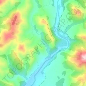
Name: Ngaroma Stream topographic map, elevation, terrain.
Location: Ngaroma Stream, Hurunui District, Canterbury, New Zealand (-42.59794 173.31378 -42.58725 173.32127)
Average elevation: 200 m
Minimum elevation: 101 m
Maximum elevation: 389 m
Canterbury trails, hiking, mountain biking, running and outdoor activities
Make a donation
Other topographic maps
Click on a map to view its topography, its elevation and its terrain.
Akaroa
New Zealand > Canterbury > Christchurch City > Banks Peninsula Community
Average elevation: 152 m
Lake Ōhau
New Zealand > Canterbury > Waitaki District
Wilding Pines (Pinus Cortorta, Pinus sylvestris) are problematic on the foreshore of Lake Ōhau. Pinus contorta grow “probably five to 10 times faster” in the Mackenzie Country (and Lake Ōhau) than in their native North America. They can establish themselves at altitudes of up to 2000 metres. Where they…
Average elevation: 904 m
Make a donation
Banks Peninsula
New Zealand > Canterbury > Christchurch City > Banks Peninsula Community > Pigeon Bay
Average elevation: 277 m
Le Bons Bay
New Zealand > Canterbury > Christchurch City > Banks Peninsula Community
Average elevation: 244 m
Make a donation
Lyttelton
New Zealand > Canterbury > Christchurch City > Banks Peninsula Community
Average elevation: 99 m
Methven
New Zealand > Canterbury > Ashburton District
Methven (Māori: Piwakawaka) is a small town in the Canterbury region of the South Island of New Zealand. It is located near the western edge of the Canterbury Plains, 35 kilometres north of Ashburton and 95 kilometres west of Christchurch, and at an elevation of 320 m. The town is a service centre for…
Average elevation: 322 m
Make a donation
Make a donation
Governors Bay
New Zealand > Canterbury > Christchurch City > Banks Peninsula Community
Average elevation: 167 m
Make a donation
Birdlings Flat
New Zealand > Canterbury > Christchurch City > Banks Peninsula Community
Average elevation: 15 m
Loburn
New Zealand > Canterbury > Waimakariri District
The Loburn-Ashley fault zone is located from the northern banks of the Ashley River through to about Hodgsons road in the north, it runs parallel to the Ashley river. The Loburn fault, which runs along the south side of Hodgsons Road, is responsible for various terraced abandoned stream channels, wedge…
Average elevation: 110 m
Make a donation
Burkes Pass
New Zealand > Canterbury > Mackenzie District
Burkes Pass is a mountain pass and at its base, a small town on State Highway 8 at the entrance to the Mackenzie Country in South Canterbury, New Zealand. It is named after Michael John Burke (1812 Co. Galway-1869 Ballarat), a graduate of Trinity College Dublin, who drove a team of bullocks through the…
Average elevation: 622 m
Cass
New Zealand > Canterbury > Selwyn District
The topography of the Cass area was formed by repeated glaciation in the Pleistocene, with the valley floor built up by river fans as the glaciers retreated and the nearby Lakes Sarah and Grasmere enclosed by moraines and ice-eroded rocks. Many of the valleys around Cass post-date the retreat of the Poulter…
Average elevation: 667 m
Make a donation
Make a donation
Little River
New Zealand > Canterbury > Christchurch City > Banks Peninsula Community
Average elevation: 220 m
Make a donation
Port hills
New Zealand > Canterbury > Christchurch City > Linwood-Central-Heathcote Community
Average elevation: 246 m
Make a donation
Bossu
New Zealand > Canterbury > Christchurch City > Banks Peninsula Community
Average elevation: 409 m
Make a donation
Ōhinetahi
New Zealand > Canterbury > Christchurch City > Banks Peninsula Community > Governors Bay
Average elevation: 113 m
Make a donation
Make a donation
Make a donation
Okains Bay
New Zealand > Canterbury > Christchurch City > Banks Peninsula Community
Average elevation: 148 m
Wainui
New Zealand > Canterbury > Christchurch City > Banks Peninsula Community
Average elevation: 203 m
Make a donation
Giant Totara tree
New Zealand > Canterbury > Christchurch City > Banks Peninsula Community
Average elevation: 382 m
Lindis Pass
New Zealand > Canterbury > Waitaki District
Lindis Pass (Māori: Ōmakō) (elevation 971 m) is located in the South Island of New Zealand. A carpark at the top of the pass provides access to a viewpoint and two short trails to other viewing spots.
Average elevation: 1,011 m
Make a donation
Duvauchelle
New Zealand > Canterbury > Christchurch City > Banks Peninsula Community
Average elevation: 277 m
Make a donation
Make a donation
Make a donation
Make a donation
Okuti Valley
New Zealand > Canterbury > Christchurch City > Banks Peninsula Community
Average elevation: 288 m
Make a donation
Little River
New Zealand > Canterbury > Christchurch City > Banks Peninsula Community > Little River
Average elevation: 150 m
Little Akaloa
New Zealand > Canterbury > Christchurch City > Banks Peninsula Community
Average elevation: 215 m
Purple Peak Saddle
New Zealand > Canterbury > Christchurch City > Banks Peninsula Community
Average elevation: 479 m
Make a donation
Bishops Green
New Zealand > Canterbury > Christchurch City > Halswell-Hornby-Riccarton Community
Average elevation: 17 m