Geolocate

United States topographic map

Interactive map

Click on the map to display elevation.

United States

The topography of the United States is characterized by diverse and dynamic landscapes that vary widely across the country. In the east, rolling hills and low mountains transition into the Appalachian Mountains, featuring peaks that generally reach around 6,000 feet (1,829 meters). Moving westward, the terrain shifts to the expansive Great Plains, which stretch for over 1,300 miles (2,092 meters) and are noted for their flatness, averaging around 1,000 feet (305 meters) in elevation​. The western region is dominated by the Rocky Mountains, where elevations soar, including Denali in Alaska, the highest point in North America at 20,310 feet (6,190 meters). This mountainous terrain gives way to varied landscapes such as plateaus and canyons, particularly in the Four Corners area​. Additionally, the Great Basin features an array of fault-block mountains and valleys that create a unique pattern of alternating high and low terrain, while the Pacific Northwest is marked by volcanic activity, leading to rugged, scenic vistas​. Overall, the U.S. showcases a rich tapestry of geological formations and elevations, reflecting its complex geological history and climatic conditions.

About this map

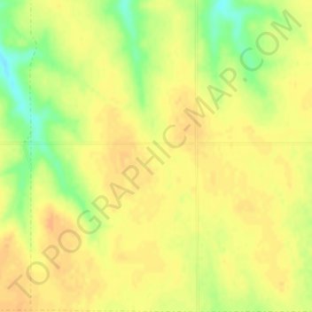
Name: United States topographic map, elevation, terrain.

Location: United States (-14.76084 -180.00000 71.58895 180.00000)

Average elevation: 309 m

Minimum elevation: -29 m

Maximum elevation: 5,001 m

Other topographic maps

Click on a map to view its topography, its elevation and its terrain.

Auckland

New Zealand > Auckland

The Auckland Volcanic Field has contributed greatly to the growth and prosperity of the Auckland Region since the area was settled by humans. Initially, the maunga (scoria cones) were occupied and established as pā (fortified settlements) by Māori due to the strategic advantage their elevation provided in…

Average elevation: 32 m

Wellington

New Zealand > Wellington > Wellington City

Averaging 2,055 hours of sunshine per year, the climate of Wellington is temperate marine, (Köppen: Cfb), generally moderate all year round with warm summers and mild winters, and rarely sees temperatures above 23 °C (73 °F) or below 4 °C (39 °F). The hottest recorded temperature in the city is 31.1 °C…

Average elevation: 85 m

San Jose del Monte

Philippines > Bulacan

The elevation of the city ranges from approximately 40 to 900 meters (130 to 2,950 ft) above sea level; the relief transitions from warm lowland to cool upland as one goes eastward. This is because the city is part of the Sierra Madre mountain range. Plains and river valley flats characterize the western and…

Average elevation: 106 m

Brisbane

Australia > Queensland > Brisbane

Average elevation: 45 m

Melrose

United States > Tennessee > Blount County

Average elevation: 334 m

Bukit Linchu

Malaysia > Johor

Average elevation: 83 m

Bukit Lin Hye

Malaysia > Johor

Average elevation: 36 m

Hamilton

New Zealand > Waikato > Hamilton City > Hamilton

Average elevation: 53 m

San Rafael

Philippines > Iloilo > Tigbauan

Average elevation: 36 m

Wānaka

New Zealand > Queenstown-Lakes District

Average elevation: 381 m

Bukit Churam

Malaysia > Johor

Average elevation: 96 m

Bukit Belah

Malaysia > Johor

Average elevation: 30 m

Bukit Jinsir

Malaysia > Johor

Average elevation: 80 m

Kinanga

Philippines > Davao Occidental > Don Marcelino

Average elevation: 97 m

Parit Jawa

Malaysia > Johor

Average elevation: 5 m

Beechmont

Australia > Queensland

Average elevation: 413 m

Clark

Philippines > Pampanga

The development is not a flood-prone area with its minimum elevation being at 54 metres (177 ft) above sea level and its planned central park also serves as a flood catchment basin. The Sierra Madre mountain range is located on the development's east while the Zambales mountain range is located on the west,…

Average elevation: 190 m

Earth

United States > Texas > Lamb County > Earth > Earth

Average elevation: 1,129 m

Washington, D.C.

United States of America > Washington, D.C. > Washington, D.C.

The highest natural elevation in the District is 409 feet (125 m) above sea level at Fort Reno Park in upper northwest Washington. The lowest point is sea level at the Potomac River. The geographic center of Washington is near the intersection of 4th and L Streets NW.

Average elevation: 63 m

Dunedin

New Zealand > Otago > Dunedin City

The climate of Dunedin in general is temperate. The city is recognised as having a large number of microclimates and the weather conditions often vary between suburbs mostly due to the city's topographical layout. Under the Köppen climate classification, Dunedin features an oceanic climate. The city's climate…

Average elevation: 110 m

Bukit Jintan

Malaysia > Johor

Average elevation: 50 m

Bukit Belah

Indonesia > Riau Islands > Lingga

Average elevation: 16 m

Langkaan

Philippines > Quezon > Dolores > Kinabuhayan

Average elevation: 706 m

Balingasag

Philippines > Misamis Oriental

Average elevation: 30 m

Grand Ethiopian Renaissance Dam

Ethiopia > Benishangul-Gumuz Region

The first phase of filling the reservoir began in July 2020 and in August 2020 the water level rose to an altitude of 540 meters (40 meters higher than the bottom of the river, which is at an altitude of 500 meters above sea level). The second phase of filling was completed on 19 July 2021, with water levels…

Average elevation: 555 m

Eva

United States > Tennessee > Benton County

Average elevation: 124 m

Maulawin

Philippines > Rizal > Jalajala > Bagumbong

Average elevation: 92 m

Tagaytay

Philippines > Cavite > Tagaytay > Tagaytay

The southern and eastern portions of Tagaytay are covered by hills and mountains which is generally forests, pine trees and open grasslands. The city lies along Tagaytay Ridge, a ridge stretching about 32 kilometres (20 mi) from Mount Batulao in the west to Mount Sungay in the east with elevations averaging…

Average elevation: 229 m

Antipolo

Philippines > Rizal

Its higher elevation than that of Metro Manila affords it a scenic view of the metropolis, especially at night. Its locally grown mangoes and cashews are popular among tourists, as well as suman – a local delicacy made out of glutinous rice. The Hinulugang Taktak National Park, which was once a popular…

Average elevation: 125 m

Bukit Simbang

Malaysia > Johor

Average elevation: 116 m

Bukit Harimau

Malaysia > Johor

Average elevation: 179 m

Bukit Belakang Padang

Malaysia > Johor

Average elevation: 295 m

Bukit Wah Wah

Malaysia > Johor

Average elevation: 92 m

The Terrace

Australia > New South Wales > Sydney

Average elevation: 31 m

Kampung La

Malaysia > Terengganu

Average elevation: 44 m

Podujevë

Kosovo

Average elevation: 778 m

Pachacámac

Peru > Lima > Lurín

Average elevation: 327 m

Calamba

Philippines > Laguna > Calamba > Calamba

Average elevation: 100 m

Berlin

Germany > Berlin > Berlin

Berlin straddles the banks of the River Spree, which flows into the River Havel (a tributary of the River Elbe) in the western borough of Spandau. Among the city's main topographical features are the many lakes in the western and southeastern boroughs formed by the Spree, Havel, and Dahme rivers (the largest…

Average elevation: 47 m

London

United Kingdom > England > London

Average elevation: 42 m

Manania

Brazil > Amazonas > Santa Isabel do Rio Negro

Average elevation: 41 m

Siliguri

India > West Bengal > Siliguri Subdivsion

Siliguri is located at the foothills of the eastern Himalayas at a location of 26°43′N 88°26′E / 26.71°N 88.43°E / 26.71; 88.43. The city is spread over an area of 260 km2 (100 sq mi) within the Siliguri Corridor. The city is bordered by dense forests to the north and the Mahananda River flows…

Average elevation: 121 m

Jezerc

Kosovo

Average elevation: 1,126 m

Bajgorë

Kosovo

Average elevation: 1,213 m

Koliq

Kosovo

Average elevation: 826 m

Nallathanniya

Sri Lanka > Central Province

Average elevation: 1,458 m

FELDA Sungai Panching Utara

Malaysia > Pahang

Average elevation: 39 m

Onewhero

New Zealand > Waikato > Waikato District

Average elevation: 145 m

Marsden

New Zealand > West Coast > Grey District

Average elevation: 76 m

Auckland Domain

New Zealand > Auckland > Auckland

During the 2023 Auckland Anniversary Weekend floods, a lake reformed in the lower elevation area of Pukekawa / Auckland Domain that was once a wetland.

Average elevation: 49 m

Queenstown

New Zealand > Queenstown-Lakes District

The town is at a relatively low altitude for a ski and snowboarding centre, at 310 metres (1,020 ft) above sea level at the lake shore, but is nestled among mountains, most notably the scenic attraction of The Remarkables, to the town's southeast. Below the lake lies the deep Kawarau Gorge, and there are…

Average elevation: 592 m

Tauranga

New Zealand > Bay of Plenty > Tauranga City

Average elevation: 66 m

Prizren

Kosovo

Average elevation: 914 m

Tinsukia

India > Assam > Tinsukia

Tinsukia is located at 27°30′N 95°22′E / 27.5°N 95.37°E / 27.5; 95.37. It has an average elevation of 116 metres (380 feet).

Average elevation: 123 m

Agpipili

Philippines > Iloilo

Average elevation: 132 m

Quaking Houses

United Kingdom > England > County Durham > Stanley

Average elevation: 206 m

Tarlac City

Philippines > Tarlac > Tarlac City

Average elevation: 56 m

Baguio

Philippines > Benguet > Baguio

In 1903, Filipinos, Japanese and Chinese workers were hired to build Kennon Road, the first road directly connecting Baguio with the lowlands of La Union and Pangasinan. Before this, the only road to Benguet was Naguilian Road, and it was largely a horse trail at higher elevations. Camp John Hay was…

Average elevation: 882 m

Nelson

New Zealand > Nelson

Average elevation: 207 m

Mount Ararat

Turkey > Iğdır

Mount Ararat, also known as Masis or officially Mount Ağrı, is a snow-capped and dormant compound volcano in easternmost Turkey. It consists of two major volcanic cones: Greater Ararat and Little Ararat. Greater Ararat is the highest peak in Turkey and the Armenian highlands with an elevation of 5,137 m…

Average elevation: 4,582 m

Ihumātao

New Zealand > Auckland > Māngere-Ōtāhuhu

Average elevation: 8 m

Silangan

Philippines > Quezon > Infanta

Average elevation: 4 m

Ruru

New Zealand > Moana > Ruru

Average elevation: 124 m

Ipilan

Philippines > Palawan

Average elevation: 71 m

Palmerston North

New Zealand > Palmerston North

Average elevation: 118 m

Batudaa

Indonesia > Gorontalo > Pohuwato

Average elevation: 40 m

Puro

Philippines > Ilocos Sur

Average elevation: 1 m

Răchițele

Romania > Cluj

Average elevation: 986 m

Victoria

Ukraine > Donetsk Oblast

Average elevation: 181 m

Takrouna

Tunisia > Sousse > تكرونة

Average elevation: 48 m

Capas

Philippines > Tarlac > Capas

Average elevation: 52 m

Kandahar

Afghanistan > Kandahar Province > Kandahar

Kandahar is a city in Afghanistan, located in the south of the country on Arghandab River, at an elevation of 1,010 m (3,310 ft). It is Afghanistan's second largest city, after Kabul, with a population of about 614,118 in 2015. It is the capital of Kandahar Province and the centre of the larger cultural region…

Average elevation: 1,048 m

Francel Town Homes

Philippines > Cavite > Bacoor

Average elevation: 5 m

Mount Kibuwa

Philippines > Bukidnon > Impasugong

Average elevation: 860 m

Nahapay

Philippines > Iloilo > Guimbal

Average elevation: 84 m

Cotcot

Philippines > Cebu

Average elevation: 12 m

Proper 1

Philippines > Cebu > Tangke

Average elevation: 69 m

Stanishor - Stanišor

Kosovo

Average elevation: 600 m

Prevlak

Kosovo

Average elevation: 894 m

White Hill

United Kingdom > England > Lancashire > Lancaster

Average elevation: 455 m

Gisborne

New Zealand > Gisborne > Gisborne District

Average elevation: 70 m

Kaytambog

Philippines > Cavite > Indang

Average elevation: 294 m

Tolarucan,Janiuay

Philippines > Iloilo

Average elevation: 51 m

Dagmay

Philippines > Palawan > El Nido

Average elevation: 56 m

Camangahan

Philippines > Iloilo > Guimbal

Average elevation: 67 m

Gllamnik

Kosovo

Average elevation: 599 m

Cabanao

Philippines > Benguet > La Trinidad > Balili

Average elevation: 1,311 m