
Make a donation
Japan topographic map
Click on the map to display elevation.
Make a donation
Japan
Japan's topography is dominated by rugged, mountainous terrain, with over four-fifths of its landmass consisting of mountains. The country's volcanic origins contribute to the striking landscape, with towering peaks and active volcanoes, including the iconic Mount Fuji, which rises to 12,388 feet (3,776 meters). The Japanese Alps, which run through Honshu, feature some of the highest peaks in the country, often exceeding 9,800 feet (3,000 meters). Despite the challenging mountainous environment, fertile valleys and coastal plains offer opportunities for agriculture, particularly in low-lying areas along the Pacific coast. The intricate coastline, shaped by steep cliffs, bays, and sandy beaches, further enhances the country's scenic beauty
Make a donation
About this map
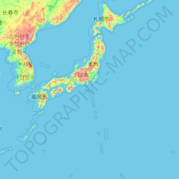
Name: Japan topographic map, elevation, terrain.
Location: Japan (20.21458 122.71418 45.71120 154.20554)
Average elevation: 58 m
Minimum elevation: -2 m
Maximum elevation: 2,683 m
Make a donation
Other topographic maps
Click on a map to view its topography, its elevation and its terrain.
Auckland
Auckland’s topography is uniquely shaped by its position on a narrow, undulating isthmus between the Waitematā Harbour to the north and the Manukau Harbour to the south, creating a landscape defined by low coastal plains interrupted by abrupt volcanic relief. The city stands atop the Auckland Volcanic…
Average elevation: 32 m
Wellington
New Zealand > Wellington > Wellington City
Averaging 2,055 hours of sunshine per year, the climate of Wellington is temperate marine, (Köppen: Cfb), generally moderate all year round with warm summers and mild winters, and rarely sees temperatures above 23 °C (73 °F) or below 4 °C (39 °F). The hottest recorded temperature in the city is 31.1 °C…
Average elevation: 85 m
Washington, D.C.
United States of America > Washington, D.C. > Washington, D.C.
The highest natural elevation in the District is 409 feet (125 m) above sea level at Fort Reno Park in upper northwest Washington. The lowest point is sea level at the Potomac River. The geographic center of Washington is near the intersection of 4th and L Streets NW.
Average elevation: 63 m
Make a donation
San Jose del Monte
The elevation of the city ranges from approximately 40 to 900 meters (130 to 2,950 ft) above sea level; the relief transitions from warm lowland to cool upland as one goes eastward. This is because the city is part of the Sierra Madre mountain range. Plains and river valley flats characterize the western and…
Average elevation: 106 m
Dunedin
New Zealand > Otago > Dunedin City
The climate of Dunedin in general is temperate. The city is recognised as having a large number of microclimates and the weather conditions often vary between suburbs mostly due to the city's topographical layout. Under the Köppen climate classification, Dunedin features an oceanic climate. The city's climate…
Average elevation: 110 m
Make a donation
Berlin
Berlin straddles the banks of the River Spree, which flows into the River Havel (a tributary of the River Elbe) in the western borough of Spandau. Among the city's main topographical features are the many lakes in the western and southeastern boroughs formed by the Spree, Havel, and Dahme rivers (the largest…
Average elevation: 47 m
Make a donation
Make a donation
Make a donation
Mount Arthur
Mount Arthur (Tuao Wharepapa in Māori) is in the Wharepapa / Arthur Range in the north western area of the South Island of New Zealand. Mount Arthur, named after Captain Arthur Wakefield, lies within Kahurangi National Park and has a peak elevation of 1,795 metres (5,889 ft).
Average elevation: 1,447 m
Make a donation
Make a donation
Tagaytay
Philippines > Cavite > Tagaytay > Tagaytay
The southern and eastern portions of Tagaytay are covered by hills and mountains which is generally forests, pine trees and open grasslands. The city lies along Tagaytay Ridge, a ridge stretching about 32 kilometres (20 mi) from Mount Batulao in the west to Mount Sungay in the east with elevations averaging…
Average elevation: 229 m
Make a donation
Make a donation
Make a donation
Houston
United States > Texas > Harris County > Houston
Houston is located 165 miles (266 km) east of Austin, 88 miles (142 km) west of the Louisiana border, and 250 miles (400 km) south of Dallas. The city has a total area of 637.4 square miles (1,651 km2); this comprises over 599.59 square miles (1,552.9 km2) of land and 22.3 square miles (58 km2) covered by…
Average elevation: 18 m
Baguio
Philippines > Benguet > Baguio
In 1903, Filipinos, Japanese and Chinese workers were hired to build Kennon Road, the first road directly connecting Baguio with the lowlands of La Union and Pangasinan. Before this, the only road to Benguet was Naguilian Road, and it was largely a horse trail at higher elevations. Camp John Hay was…
Average elevation: 882 m
Make a donation
Mitre Peak
New Zealand > Southland > Southland District > Fiordland Community
Average elevation: 657 m
Make a donation
Make a donation
Make a donation
Greytown
New Zealand > Wellington > South Wairarapa District > Greytown Community
Average elevation: 59 m
Cromwell
New Zealand > Otago > Central Otago District > Cromwell Community > Cromwell
Average elevation: 330 m
Make a donation
Make a donation
Make a donation
Make a donation
Make a donation
Make a donation
Make a donation
Make a donation
Make a donation
Make a donation
Make a donation