Geolocate

Tonga topographic map

Click on the map to display elevation.

About this map

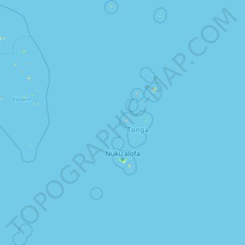
Name: Tonga topographic map, elevation, terrain.

Location: Tonga (-24.16354 -179.39502 -15.36557 -173.52955)

Average elevation: 0 m

Minimum elevation: 0 m

Maximum elevation: 489 m

Other topographic maps

Click on a map to view its topography, its elevation and its terrain.

Auckland

New Zealand > Auckland

Auckland’s topography is uniquely shaped by its position on a narrow, undulating isthmus between the Waitematā Harbour to the north and the Manukau Harbour to the south, creating a landscape defined by low coastal plains interrupted by abrupt volcanic relief. The city stands atop the Auckland Volcanic…

Average elevation: 32 m

Wellington

New Zealand > Wellington > Wellington City

Averaging 2,055 hours of sunshine per year, the climate of Wellington is temperate marine, (Köppen: Cfb), generally moderate all year round with warm summers and mild winters, and rarely sees temperatures above 23 °C (73 °F) or below 4 °C (39 °F). The hottest recorded temperature in the city is 31.1 °C…

Average elevation: 85 m

Earth

United States > Texas > Lamb County > Earth > Earth

Average elevation: 1,129 m

Dunedin

New Zealand > Otago > Dunedin City

The climate of Dunedin in general is temperate. The city is recognised as having a large number of microclimates and the weather conditions often vary between suburbs mostly due to the city's topographical layout. Under the Köppen climate classification, Dunedin features an oceanic climate. The city's climate…

Average elevation: 110 m

Queenstown

New Zealand > Otago > Queenstown-Lakes District

The town is at a relatively low altitude for a ski and snowboarding centre, at 310 metres (1,020 ft) above sea level at the lake shore, but is nestled among mountains, most notably the scenic attraction of The Remarkables, to the town's southeast. Below the lake lies the deep Kawarau Gorge, and there are…

Average elevation: 592 m

Brisbane

Australia > Queensland > Brisbane

Average elevation: 45 m

Hamilton

New Zealand > Waikato > Hamilton City > Hamilton

Average elevation: 53 m

Ararimu

New Zealand > Auckland > Franklin

Average elevation: 199 m

Ruru

New Zealand > Moana > Ruru

Average elevation: 124 m

Antipolo

Philippines > Rizal

Its higher elevation than that of Metro Manila affords it a scenic view of the metropolis, especially at night. Its locally grown mangoes and cashews are popular among tourists, as well as suman – a local delicacy made out of glutinous rice. The Hinulugang Taktak National Park, which was once a popular…

Average elevation: 125 m

Ōkura

New Zealand > Auckland > Hibiscus and Bays

Average elevation: 38 m

Tauranga

New Zealand > Bay of Plenty > Tauranga City

Average elevation: 66 m

Coromandel Range

New Zealand > Waikato

Average elevation: 71 m

Berlin

Germany > Berlin > Berlin

Berlin straddles the banks of the River Spree, which flows into the River Havel (a tributary of the River Elbe) in the western borough of Spandau. Among the city's main topographical features are the many lakes in the western and southeastern boroughs formed by the Spree, Havel, and Dahme rivers (the largest…

Average elevation: 47 m

Lower Hutt

New Zealand > Wellington > Lower Hutt City

Average elevation: 173 m

Rolleston

New Zealand > Canterbury > Selwyn District

Average elevation: 54 m

Hope Range

New Zealand

Average elevation: 943 m

Haupiri Range

New Zealand

Average elevation: 996 m

Tasman Mountains

New Zealand

Average elevation: 842 m

Burnett Range

New Zealand

Average elevation: 168 m

Travers Range

New Zealand

Average elevation: 1,159 m

Wakamarama Range

New Zealand

Average elevation: 444 m

Lookout Range

New Zealand

Average elevation: 1,194 m

Mount Crosscut

New Zealand

Average elevation: 1,276 m

Mount Arthur

New Zealand

Mount Arthur (Tuao Wharepapa in Māori) is in the Wharepapa / Arthur Range in the north western area of the South Island of New Zealand. Mount Arthur, named after Captain Arthur Wakefield, lies within Kahurangi National Park and has a peak elevation of 1,795 metres (5,889 ft).

Average elevation: 1,447 m

Mount Travers

New Zealand

Average elevation: 1,658 m

Saint Arnaud

New Zealand

Average elevation: 713 m

Lake Rotoroa

New Zealand

Average elevation: 747 m

Wainui Falls

New Zealand

Average elevation: 279 m

Taoroa

New Zealand

Average elevation: 11 m

Fairdown

New Zealand

Average elevation: 14 m

Wendon Valley

New Zealand

Average elevation: 200 m

Waikaka

New Zealand

Average elevation: 347 m

Timore Island

New Zealand

Average elevation: 1 m

Arawhata

New Zealand

Average elevation: 103 m

Mangapurua

New Zealand

Average elevation: 483 m

Ngamatapouri

New Zealand

Average elevation: 160 m

Arapohue

New Zealand

Average elevation: 55 m

Moawhango River

New Zealand

Average elevation: 668 m

Tokomaru River

New Zealand

Average elevation: 396 m

Mount Dobson

New Zealand

Average elevation: 1,749 m

Riwaka

New Zealand

Average elevation: 10 m

Mackinnon Pass

New Zealand

Average elevation: 843 m

Marshall Islands

The average altitude above sea level for the entire country is 7 feet (2.1 m).

Average elevation: 0 m

Baguio

Philippines > Benguet > Baguio

In 1903, Filipinos, Japanese and Chinese workers were hired to build Kennon Road, the first road directly connecting Baguio with the lowlands of La Union and Pangasinan. Before this, the only road to Benguet was Naguilian Road, and it was largely a horse trail at higher elevations. Camp John Hay was…

Average elevation: 882 m

Central Plateau

New Zealand

Average elevation: 204 m

Māpua

New Zealand

Average elevation: 23 m

Richmond

New Zealand > Tasman > Tasman District

Average elevation: 83 m

Scario

Italy > Campania > Salerno > San Giovanni a Piro

Average elevation: 88 m

Colonial Knob

New Zealand > Wellington > Porirua City > Porirua

Average elevation: 275 m

Waikouaiti

New Zealand > Otago > Dunedin City

Average elevation: 448 m

Lincoln

New Zealand > Selwyn District

Average elevation: 15 m

Waitoki

New Zealand > Auckland > Rodney

Average elevation: 47 m

Whangaparaoa

New Zealand > Bay of Plenty

Average elevation: 35 m

Wānaka

New Zealand > Otago > Queenstown-Lakes District

Average elevation: 381 m

Upper Hutt

New Zealand > Wellington > Upper Hutt City

Average elevation: 271 m

Pegasus Bay

New Zealand > Canterbury

Average elevation: 0 m

Whareama River

New Zealand > Wellington

Average elevation: 163 m

Bryant Range

New Zealand > Marlborough

Average elevation: 418 m

Two Thumb Range

New Zealand > Canterbury

Average elevation: 1,138 m

Ruahine Range

New Zealand > Manawatu-Whanganui

Average elevation: 467 m

Southern Alps

New Zealand > West Coast

Average elevation: 770 m

Taradale

New Zealand > Hawke's Bay

Average elevation: 27 m

Leigh

United Kingdom > England

Average elevation: 34 m

Onekaka

New Zealand > Tasman

Average elevation: 73 m

San Juan

Philippines

"San Juan" is a contraction of the city's traditional name of "San Juan del Monte" (lit. 'Saint John of the Mountain'). As with numerous other places in the Philippines, the name combines a patron saint and a toponym; in this case Saint John the Baptist with the locale's hilly terrain and relatively higher…

Average elevation: 35 m

Africa

Average elevation: 462 m

Brightwater

New Zealand > Tasman

Average elevation: 73 m

Wakefield

New Zealand > Tasman

Average elevation: 134 m

Lindis Pass

New Zealand > Canterbury > Waitaki District

Lindis Pass (Māori: Ōmakō) (elevation 971 m) is located in the South Island of New Zealand. A carpark at the top of the pass provides access to a viewpoint and two short trails to other viewing spots.

Average elevation: 1,011 m

Leatham River

New Zealand > Marlborough

Average elevation: 1,234 m

Ruby Bay

New Zealand > Tasman

Average elevation: 23 m

Devils Staircase

New Zealand > Marlborough

Average elevation: 372 m

Hossack Saddle

New Zealand > Marlborough

Average elevation: 875 m

Tiniroto

New Zealand > Gisborne

Average elevation: 328 m

Golden Downs

New Zealand > Tasman

Average elevation: 388 m

Redwood Valley

New Zealand > Tasman

Average elevation: 46 m

Te Karaka

New Zealand > Gisborne

Average elevation: 77 m

Karaka Island

New Zealand > Northland

Average elevation: 13 m

Karamea (Red Island)

New Zealand > Hawke's Bay

Average elevation: 41 m

Motonui Island

New Zealand > Bay of Plenty

Average elevation: 10 m

Rangitaiki River

New Zealand > Bay of Plenty

Average elevation: 593 m

Selwyn River

New Zealand > Canterbury

Average elevation: 194 m

Lake Whakamaru

New Zealand > Waikato

Average elevation: 399 m

Blake

New Zealand > Wellington

Average elevation: 568 m

Te Puninga

New Zealand > Waikato

Average elevation: 14 m

Mount Pirongia

New Zealand > Waikato

Average elevation: 721 m

Lake Alexandrina

New Zealand > Canterbury

Average elevation: 738 m

Otewa

New Zealand > Waikato

Average elevation: 71 m

Hauturu Island

New Zealand > Waikato

Average elevation: 3 m

Manutahi Island

New Zealand > Waikato

Average elevation: 14 m

Rotokawa

New Zealand > Waikato

Average elevation: 347 m

Ngaroma Stream

New Zealand > Canterbury

Average elevation: 200 m