
Make a donation
Rwanda topographic map
Click on the map to display elevation.
Make a donation
Rwanda
At 26,338 square kilometres (10,169 sq mi), Rwanda is the world's 149th-largest country, and the fourth smallest on the African mainland after Gambia, Eswatini, and Djibouti. It is comparable in size to Burundi, Haiti and Albania. The entire country is at a high altitude: the lowest point is the Rusizi River at 950 metres (3,117 ft) above sea level. Rwanda is located in Central/Eastern Africa, and is bordered by the Democratic Republic of the Congo to the west, Uganda to the north, Tanzania to the east, and Burundi to the south. It lies a few degrees south of the equator and is landlocked. The capital, Kigali, is located near the centre of Rwanda.
Make a donation
About this map
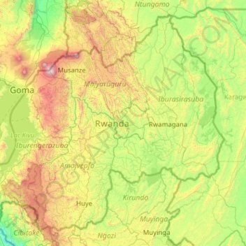
Name: Rwanda topographic map, elevation, terrain.
Location: Rwanda (-2.83976 28.86170 -1.04741 30.89907)
Average elevation: 1,625 m
Minimum elevation: 835 m
Maximum elevation: 4,334 m
Make a donation
Other topographic maps
Click on a map to view its topography, its elevation and its terrain.
Auckland
Auckland’s topography is uniquely shaped by its position on a narrow, undulating isthmus between the Waitematā Harbour to the north and the Manukau Harbour to the south, creating a landscape defined by low coastal plains interrupted by abrupt volcanic relief. The city stands atop the Auckland Volcanic…
Average elevation: 32 m
São José do Rio Preto
Brazil > São Paulo > Região Metropolitana de São José do Rio Preto
Average elevation: 524 m
Make a donation
Wellington
New Zealand > Wellington > Wellington City
Averaging 2,055 hours of sunshine per year, the climate of Wellington is temperate marine, (Köppen: Cfb), generally moderate all year round with warm summers and mild winters, and rarely sees temperatures above 23 °C (73 °F) or below 4 °C (39 °F). The hottest recorded temperature in the city is 31.1 °C…
Average elevation: 85 m
San Jose del Monte
The elevation of the city ranges from approximately 40 to 900 meters (130 to 2,950 ft) above sea level; the relief transitions from warm lowland to cool upland as one goes eastward. This is because the city is part of the Sierra Madre mountain range. Plains and river valley flats characterize the western and…
Average elevation: 106 m
Washington, D.C.
United States of America > Washington, D.C. > Washington, D.C.
The highest natural elevation in the District is 409 feet (125 m) above sea level at Fort Reno Park in upper northwest Washington. The lowest point is sea level at the Potomac River. The geographic center of Washington is near the intersection of 4th and L Streets NW.
Average elevation: 63 m
Tagaytay
Philippines > Cavite > Tagaytay > Tagaytay
The southern and eastern portions of Tagaytay are covered by hills and mountains which is generally forests, pine trees and open grasslands. The city lies along Tagaytay Ridge, a ridge stretching about 32 kilometres (20 mi) from Mount Batulao in the west to Mount Sungay in the east with elevations averaging…
Average elevation: 229 m
Make a donation
Dunedin
New Zealand > Otago > Dunedin City
The climate of Dunedin in general is temperate. The city is recognised as having a large number of microclimates and the weather conditions often vary between suburbs mostly due to the city's topographical layout. Under the Köppen climate classification, Dunedin features an oceanic climate. The city's climate…
Average elevation: 110 m
Queenstown
New Zealand > Otago > Queenstown-Lakes District
The town is at a relatively low altitude for a ski and snowboarding centre, at 310 metres (1,020 ft) above sea level at the lake shore, but is nestled among mountains, most notably the scenic attraction of The Remarkables, to the town's southeast. Below the lake lies the deep Kawarau Gorge, and there are…
Average elevation: 592 m
Make a donation
Berlin
Berlin straddles the banks of the River Spree, which flows into the River Havel (a tributary of the River Elbe) in the western borough of Spandau. Among the city's main topographical features are the many lakes in the western and southeastern boroughs formed by the Spree, Havel, and Dahme rivers (the largest…
Average elevation: 47 m
Make a donation
Palmerston North
New Zealand > Manawatu-Whanganui > Palmerston North City
Although the land Palmerston North is situated on is bounded by the lofty Ruahine and Tararua ranges in the east and south respectively, the city has a predominantly flat appearance. The occasional rise in elevation occurs further away from the river and is especially pronounced in the north and northeast, and…
Average elevation: 118 m
Make a donation
Make a donation
Make a donation
Mount Arthur
Mount Arthur (Tuao Wharepapa in Māori) is in the Wharepapa / Arthur Range in the north western area of the South Island of New Zealand. Mount Arthur, named after Captain Arthur Wakefield, lies within Kahurangi National Park and has a peak elevation of 1,795 metres (5,889 ft).
Average elevation: 1,447 m
Make a donation
Make a donation
Make a donation
Make a donation
Make a donation
Make a donation
Aluva
Aluva Railway Station (IR Code: AWY) is a grade-A station and the third busiest in Kochi after Ernakulam Junction railway station and Ernakulam Town railway station. Every passenger and express train bound for southern Kerala stops here. Travelers from the Idukki district typically use either the Aluva or the…
Average elevation: 11 m
Make a donation
Kā Whata-Tū-o-Rakihouia / Seaward Kaikōura Range
New Zealand > Kaikōura District
Average elevation: 839 m
Make a donation
Mount Cook
New Zealand > Canterbury > Mackenzie District
Temperatures at the mountain's base in the Hooker Valley around 800 metres (2,600 feet) range from −13 °C (9 °F) to 32 °C (90 °F), and generally fall just over 1 °C for every 200 metres of altitude.
Average elevation: 2,920 m
Reefton
New Zealand > West Coast > Buller District
Located in the Inangahua Valley at an altitude of 194m, Reefton falls under the Köppen-Geiger climate classification of Cfb (Oceanic), though the town's sheltered inland location lends its climate less maritime influence than coastal areas; as such, Reefton has recorded both the extreme highest temperature of…
Average elevation: 310 m
Make a donation
Picton
New Zealand > Marlborough > Marlborough District
On the land side, Picton is surrounded by hills and mountains, including Te Tara-o-Te-Marama/Mount Freeth to the west, the Robertson Range to the south and Mount McCormick to the east. The Elevation Saddle connects southwest of the town with the Tuamarina River valley and contains the main land transport…
Average elevation: 193 m
Make a donation
Make a donation
Make a donation
Make a donation
Make a donation
Make a donation
Make a donation
Mount Banahaw and San Cristobal Protected Landscape
Philippines > Laguna > Liliw
Average elevation: 592 m
Make a donation
Make a donation