
Make a donation
Pakistan topographic map
Click on the map to display elevation.
Make a donation
Pakistan
The diverse landscape and climate in Pakistan support a wide range of trees and plants. From coniferous alpine and subalpine trees like spruce, pine, and deodar cedar in the northern mountains to deciduous trees like shisham in the Sulaiman Mountains, and palms such as coconut and date in the southern regions. The western hills boast juniper, tamarisk, coarse grasses, and scrub plants. Mangrove forests dominate the coastal wetlands in the south. Coniferous forests span altitudes from 1,000 to 4,000 metres (3,300 to 13,100 feet) in most northern and northwestern highlands. In Balochistan's xeric regions, date palms and Ephedra are prevalent. In Punjab and Sindh's Indus plains, tropical and subtropical dry and moist broadleaf forests as well as tropical and xeric shrublands thrive. Approximately 4.8% or 36,845.6 square kilometres (3,684,560 ha) of Pakistan was forested in 2021.
Make a donation
About this map
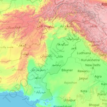
Name: Pakistan topographic map, elevation, terrain.
Location: Pakistan (23.43420 60.87286 37.08411 77.12039)
Average elevation: 1,372 m
Minimum elevation: -5 m
Maximum elevation: 7,969 m
Make a donation
Other topographic maps
Click on a map to view its topography, its elevation and its terrain.
Auckland
Auckland’s topography is uniquely shaped by its position on a narrow, undulating isthmus between the Waitematā Harbour to the north and the Manukau Harbour to the south, creating a landscape defined by low coastal plains interrupted by abrupt volcanic relief. The city stands atop the Auckland Volcanic…
Average elevation: 32 m
Wellington
New Zealand > Wellington > Wellington City
Averaging 2,055 hours of sunshine per year, the climate of Wellington is temperate marine, (Köppen: Cfb), generally moderate all year round with warm summers and mild winters, and rarely sees temperatures above 23 °C (73 °F) or below 4 °C (39 °F). The hottest recorded temperature in the city is 31.1 °C…
Average elevation: 85 m
Dunedin
New Zealand > Otago > Dunedin City
The climate of Dunedin in general is temperate. The city is recognised as having a large number of microclimates and the weather conditions often vary between suburbs mostly due to the city's topographical layout. Under the Köppen climate classification, Dunedin features an oceanic climate. The city's climate…
Average elevation: 110 m
Make a donation
Antipolo
Its higher elevation than that of Metro Manila affords it a scenic view of the metropolis, especially at night. Its locally grown mangoes and cashews are popular among tourists, as well as suman – a local delicacy made out of glutinous rice. The Hinulugang Taktak National Park, which was once a popular…
Average elevation: 125 m
Make a donation
Queenstown
New Zealand > Otago > Queenstown-Lakes District
The town is at a relatively low altitude for a ski and snowboarding centre, at 310 metres (1,020 ft) above sea level at the lake shore, but is nestled among mountains, most notably the scenic attraction of The Remarkables, to the town's southeast. Below the lake lies the deep Kawarau Gorge, and there are…
Average elevation: 592 m
Baguio
Philippines > Benguet > Baguio
In 1903, Filipinos, Japanese and Chinese workers were hired to build Kennon Road, the first road directly connecting Baguio with the lowlands of La Union and Pangasinan. Before this, the only road to Benguet was Naguilian Road, and it was largely a horse trail at higher elevations. Camp John Hay was…
Average elevation: 882 m
Make a donation
Make a donation
Make a donation
Marshall Islands
The average altitude above sea level for the entire country is 7 feet (2.1 m).
Average elevation: 0 m
Make a donation
Berlin
Berlin straddles the banks of the River Spree, which flows into the River Havel (a tributary of the River Elbe) in the western borough of Spandau. Among the city's main topographical features are the many lakes in the western and southeastern boroughs formed by the Spree, Havel, and Dahme rivers (the largest…
Average elevation: 47 m
Make a donation
Make a donation
San Juan
"San Juan" is a contraction of the city's traditional name of "San Juan del Monte" (lit. 'Saint John of the Mountain'). As with numerous other places in the Philippines, the name combines a patron saint and a toponym; in this case Saint John the Baptist with the locale's hilly terrain and relatively higher…
Average elevation: 35 m
Africa
Average elevation: 462 m
Lindis Pass
New Zealand > Canterbury > Waitaki District
Lindis Pass (Māori: Ōmakō) (elevation 971 m) is located in the South Island of New Zealand. A carpark at the top of the pass provides access to a viewpoint and two short trails to other viewing spots.
Average elevation: 1,011 m
Make a donation
Ballarat
Ballarat has a moderate oceanic climate (Köppen climate classification Cfb) with four distinct seasons. Its elevation, ranging between 400 and 630 metres (1,310 and 2,070 feet) above sea level, causes its mean monthly temperatures to tend to be on average 3 to 5 °C (5 to 9 °F) below those of Melbourne,…
Average elevation: 470 m
Make a donation
Make a donation
Mount Arthur
Mount Arthur (Tuao Wharepapa in Māori) is in the Wharepapa / Arthur Range in the north western area of the South Island of New Zealand. Mount Arthur, named after Captain Arthur Wakefield, lies within Kahurangi National Park and has a peak elevation of 1,795 metres (5,889 ft).
Average elevation: 1,447 m
Make a donation
Make a donation
Make a donation
Make a donation
Make a donation
Make a donation
Make a donation
Make a donation
San Jose del Monte
The elevation of the city ranges from approximately 40 to 900 meters (130 to 2,950 ft) above sea level; the relief transitions from warm lowland to cool upland as one goes eastward. This is because the city is part of the Sierra Madre mountain range. Plains and river valley flats characterize the western and…
Average elevation: 106 m
Houston
United States > Texas > Harris County > Houston
Houston is located 165 miles (266 km) east of Austin, 88 miles (142 km) west of the Louisiana border, and 250 miles (400 km) south of Dallas. The city has a total area of 637.4 square miles (1,651 km2); this comprises over 599.59 square miles (1,552.9 km2) of land and 22.3 square miles (58 km2) covered by…
Average elevation: 18 m
Washington, D.C.
United States of America > Washington, D.C. > Washington, D.C.
The highest natural elevation in the District is 409 feet (125 m) above sea level at Fort Reno Park in upper northwest Washington. The lowest point is sea level at the Potomac River. The geographic center of Washington is near the intersection of 4th and L Streets NW.
Average elevation: 63 m
Make a donation
Make a donation
Make a donation
Hanmer Springs
New Zealand > Hurunui District
The Jacks Pass – Clarence River – Jollies Pass Loop is a 25 kilometer loop which is not technically challenging however it takes between two to four hours to complete. It can be ridden in either direction: West over Jacks Pass (869m) or East over Jollies Pass (850m). As the entire ride is at high elevation…
Average elevation: 490 m
Cromwell
New Zealand > Otago > Central Otago District > Cromwell Community > Cromwell
Average elevation: 330 m
Ashburton
New Zealand > Canterbury > Ashburton District
On the whole, Ashburton shares a similar climate to Christchurch i.e. a dry temperate climate (Cfb). However, since it lies further inland at a higher altitude to Christchurch, Ashburton experiences a greater range of temperatures. During summer Ashburton can exceed 30 °C (86 °F), whilst winter can see…
Average elevation: 99 m
Make a donation
Taumarunui
New Zealand > Manawatu-Whanganui > Ruapehu District
Under the Köppen, Taumarunui has an Oceanic climate:(Cfb). Due to location, low altitude and Geography surroundings, Taumarunui is more liable to warm to hot summers than other central North Island centres and in winter Taumarunui is cold and frosty. Rainfall yearly is 1,449 mm (57.047244 in). Annual sunshine…
Average elevation: 245 m
Make a donation
Make a donation