
Tana River County topographic map
Interactive map
Click on the map to display elevation.
About this map
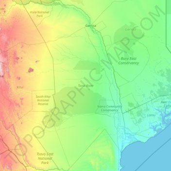
Name: Tana River County topographic map, elevation, terrain.
Location: Tana River County, Coast, Kenya (-3.06935 38.42083 -0.00398 40.73427)
Average elevation: 263 m
Minimum elevation: -1 m
Maximum elevation: 1,630 m
Other topographic maps
Click on a map to view its topography, its elevation and its terrain.
Mirangine
Kenya > Nakuru > Bahati > Bahati ward
Mirangine, Bahati ward, Bahati, Nakuru, Rift Valley, Kenya
Average elevation: 2,161 m
Karachuonyo
Karachuonyo, Homa Bay Town, Homa Bay County, Nyanza, Kenya
Average elevation: 1,221 m
Butere
Butere, Kakamega County, Western, 50101, Kenya
Average elevation: 1,383 m
Koibatek Forest
Kenya > Baringo > Eldama Ravine > Maji Mazuri
Koibatek Forest, Maji Mazuri, Eldama Ravine, Baringo, Rift Valley, Kenya
Average elevation: 2,333 m
Mau Narok
Kenya > Nakuru > Njoro > Mau Narok ward
Mau Narok, Mau Narok ward, Njoro, Nakuru, Rift Valley, Kenya
Average elevation: 2,655 m
South Mugirango
Kenya > Kisii County > Gucha South
South Mugirango, Gucha South, Kisii County, Nyanza, Kenya
Average elevation: 1,591 m
Keiyo North
Kenya > Elgeyo-Marakwet County
Keiyo North, Elgeyo-Marakwet County, Rift Valley, Kenya
Average elevation: 1,761 m
Webuye West
Webuye West, Bungoma County, Western, 50205, Kenya
Average elevation: 1,509 m
Belgut
Belgut, Kericho County, Rift Valley, 20205, Kenya
Average elevation: 1,960 m
Kipkelion West
Kipkelion West, Kericho County, Rift Valley, Kenya
Average elevation: 2,014 m
Kuresoi
Kenya > Nakuru > Kuresoi North > Kiptororo ward
Kuresoi, Kiptororo ward, Kuresoi North, Nakuru, Rift Valley, Kenya
Average elevation: 2,586 m
Marakwet West
Kenya > Elgeyo-Marakwet County
Marakwet West, Elgeyo-Marakwet County, Rift Valley, Kenya
Average elevation: 2,056 m
Mashuru
Kenya > Kajiado East > Imaroro ward
Mashuru, Imaroro ward, Kajiado East, Rift Valley, Kenya
Average elevation: 1,343 m
Bobasi
Kenya > Kisii County > Nyamache
Bobasi, Nyamache, Kisii County, Nyanza, 40200, Kenya
Average elevation: 1,821 m
Laikipia East
Laikipia East, Laikipia County, Rift Valley, 10400, Kenya
Average elevation: 2,008 m
Laikipia North
Laikipia North, Laikipia County, Rift Valley, Kenya
Average elevation: 1,715 m
Uriri
Kenya > Migori County > Uriri > Central kanyamkago ward
Uriri, Central kanyamkago ward, Uriri, Migori County, Nyanza, Kenya
Average elevation: 1,494 m
Kwanza
Kwanza, Trans-Nzoia County, Rift Valley, Kenya
Average elevation: 1,877 m
Baringo Central
Baringo Central, Baringo, Rift Valley, 30400, Kenya
Average elevation: 1,622 m
Ayugis
Kenya > Migori County > Rongo > East Kamagambo ward
Ayugis, East Kamagambo ward, Rongo, Migori County, Nyanza, 40404, Kenya
Average elevation: 1,404 m
Kipkelion East
Kipkelion East, Kericho County, Rift Valley, 20200, Kenya
Average elevation: 2,411 m
Sigowet
Kenya > Kericho County > Sigowet/Soin > Kaplerartet ward
Sigowet, Kaplerartet ward, Sigowet/Soin, Kericho County, Rift Valley, Kenya
Average elevation: 1,713 m