
Christchurch City topographic map
Interactive map
Click on the map to display elevation.
About this map
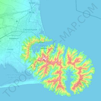
Name: Christchurch City topographic map, elevation, terrain.
Location: Christchurch City, Canterbury, New Zealand (-43.90235 172.36374 -43.38989 173.13140)
Average elevation: 74 m
Minimum elevation: -3 m
Maximum elevation: 904 m
Canterbury trails, hiking, mountain biking, running and outdoor activities
Other topographic maps
Click on a map to view its topography, its elevation and its terrain.
Port hills
New Zealand > Canterbury > Christchurch City > Linwood-Central-Heathcote Community
Average elevation: 246 m
Hanmer Springs
New Zealand > Canterbury > Hurunui District
The Jacks Pass – Clarence River – Jollies Pass Loop is a 25 kilometer loop which is not technically challenging however it takes between two to four hours to complete. It can be ridden in either direction: West over Jacks Pass (869m) or East over Jollies Pass (850m). As the entire ride is at high elevation…
Average elevation: 490 m
Cass
New Zealand > Canterbury > Selwyn District
The topography of the Cass area was formed by repeated glaciation in the Pleistocene, with the valley floor built up by river fans as the glaciers retreated and the nearby Lakes Sarah and Grasmere enclosed by moraines and ice-eroded rocks. Many of the valleys around Cass post-date the retreat of the Poulter…
Average elevation: 667 m
Banks Peninsula
New Zealand > Canterbury > Christchurch City > Banks Peninsula Community > Pigeon Bay
Average elevation: 277 m
Loburn
New Zealand > Canterbury > Waimakariri District
The Loburn-Ashley fault zone is located from the northern banks of the Ashley River through to about Hodgsons road in the north, it runs parallel to the Ashley river. The Loburn fault, which runs along the south side of Hodgsons Road, is responsible for various terraced abandoned stream channels, wedge…
Average elevation: 110 m
Birdlings Flat
New Zealand > Canterbury > Christchurch City > Banks Peninsula Community
Average elevation: 15 m
Lindis Pass
New Zealand > Canterbury > Waitaki District
Lindis Pass (Māori: Ōmakō) (elevation 971 m) is located in the South Island of New Zealand. A carpark at the top of the pass provides access to a viewpoint and two short trails to other viewing spots.
Average elevation: 1,011 m
Methven
New Zealand > Canterbury > Ashburton District
Methven (Māori: Piwakawaka) is a small town in the Canterbury region of the South Island of New Zealand. It is located near the western edge of the Canterbury Plains, 35 kilometres north of Ashburton and 95 kilometres west of Christchurch, and at an elevation of 320 m. The town is a service centre for…
Average elevation: 322 m
Giant Totara tree
New Zealand > Canterbury > Christchurch City > Banks Peninsula Community
Average elevation: 382 m
Governors Bay
New Zealand > Canterbury > Christchurch City > Banks Peninsula Community
Average elevation: 167 m
Mount Lyford
New Zealand > Canterbury > Hurunui District
In addition to the subdivision a commercial ski field and access road was developed in the overlooking mountains catering for families, including ice-skating, day shelter/cafeteria together with ski tows and car parking. Currently the Simpson family continues to operate Mt Lyford Alpine Resort ski field.…
Average elevation: 1,242 m
Lyttelton
New Zealand > Canterbury > Christchurch City > Banks Peninsula Community
Average elevation: 99 m
Burkes Pass
New Zealand > Canterbury > Mackenzie District
Burkes Pass is a mountain pass and at its base, a small town on State Highway 8 at the entrance to the Mackenzie Country in South Canterbury, New Zealand. It is named after Michael John Burke (1812 Co. Galway-1869 Ballarat), a graduate of Trinity College Dublin, who drove a team of bullocks through the…
Average elevation: 622 m
Ōhinetahi
New Zealand > Canterbury > Christchurch City > Banks Peninsula Community > Governors Bay
Average elevation: 113 m
Bossu
New Zealand > Canterbury > Christchurch City > Banks Peninsula Community
Average elevation: 409 m
Arthur's Pass
New Zealand > Canterbury > Selwyn District
Arthur's Pass township is about five kilometres (3.1 mi) south of the mountain pass with the same name. At an elevation of 740 metres (2,430 ft) above sea level, the settlement is surrounded by beech forest. The Bealey River runs through the township. The town is located 153 kilometres (95 mi) from…
Average elevation: 1,204 m
Darfield
New Zealand > Canterbury > Selwyn District
Located on the Canterbury Plains at an altitude of 193 metres (633 feet) above sea level, the Köppen-Geiger climate classification for Darfield is Cfb (Oceanic). On several days a year, Darfield is subject to the nor'west Foehn wind, which is very dry and has the capability to raise the temperature by several…
Average elevation: 202 m
Purple Peak Saddle
New Zealand > Canterbury > Christchurch City > Banks Peninsula Community
Average elevation: 479 m
Little Akaloa
New Zealand > Canterbury > Christchurch City > Banks Peninsula Community
Average elevation: 215 m
Little River
New Zealand > Canterbury > Christchurch City > Banks Peninsula Community > Little River
Average elevation: 150 m